Enderby
Enderby is a village and civil parish in Leicestershire, England, on the southwest outskirts of the city of Leicester. The parish includes the neighbourhood of St John's, which is east of the village separated from it by the M1 motorway.Photo: Chemical Engineer, CC BY-SA 3.0.
Notable Places in the Area
Brockington College
School
Brockington College is a Church of England mixed secondary school in Enderby, Leicestershire, England.
Narborough railway station
Railway station
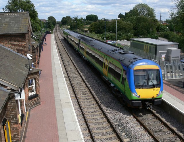
Photo: Mat Fascione, CC BY-SA 2.0.
Narborough railway station serves the large village of Narborough and the small village of Littlethorpe in Leicestershire.
All Saints Church, Narborough
Church

Photo: Kev747, Public domain.
All Saints' Church, Narborough is a parish church in the Church of England in Narborough, Leicestershire.
Localities in the Area
Narborough
Village
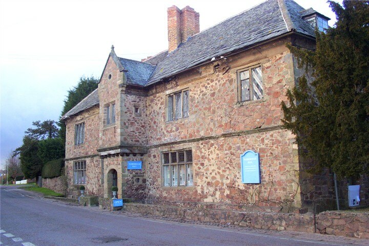
Photo: Kev747, Public domain.
Narborough is a large village and civil parish in the Blaby district of Leicestershire, England, around six miles southwest of Leicester.
Lubbesthorpe
Hamlet
Lubbesthorpe is a hamlet and parish in the district of Blaby within Enderby on the outskirts of Leicester, on the west side of the M1 motorway and the River Soar.
Littlethorpe
Village
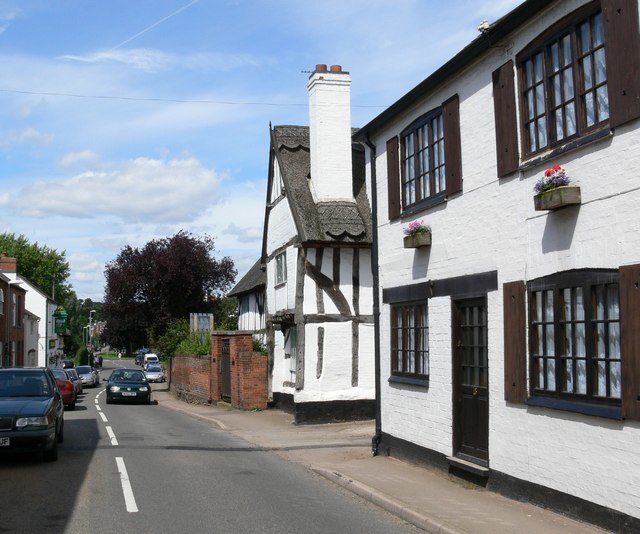
Photo: Mat Fascione, CC BY-SA 2.0.
Littlethorpe is a small village approximately six miles south of Leicester, separated from the village of Narborough by the Leicester to Birmingham railway line, and the River Soar of which it is the true discharge.
Enderby
- Type: Village with 8,110 residents
- Description: town and parish in Leicestershire, United Kingdom
- Categories: civil parish and locality
- Location: Enderby, Blaby, Leicestershire, East Midlands, England, United Kingdom, Britain and Ireland, Europe
- View on OpenStreetMap
Latitude
52.58818° or 52° 35' 17" northLongitude
-1.21219° or 1° 12' 44" westPopulation
8,110Elevation
312 feet (95 metres)United Nations Location Code
GB EDBOpen Location Code
9C4WHQQQ+74OpenStreetMap ID
node 1692291996OpenStreetMap Feature
place=villageEnderby Satellite Map
© OpenStreetMap, Mapbox and Maxar
Also Known As
- Bengali: এন্ডারবাঈ
- Cebuano: Enderby
- Chinese: 安德比
- Dutch: Enderby
- English: Enderby, Leicestershire
- French: Enderby
- German: Enderby
- Gujarati: એન્ડરબાય
- Hebrew: אנדרבי
- Irish: Enderby
- Italian: Enderby
- Japanese: エンダービー
- Kannada: ಎಂಡ್ಬೆರಿ
- Korean: 엔더비
- Ladin: Enderby
- Lithuanian: Enderbis
- Persian: اندربی، لسترشر
- Polish: Enderby
- Portuguese: Enderby
- Russian: Эндерби
- Spanish: Enderby
- Swedish: Enderby, Leicestershire
- Swedish: Enderby
- Tamil: எண்டெர்பி
- Telugu: ఎండర్బై
- Turkish: Enderby, Leicestershire
- Urdu: اندیربی
- Welsh: Enderby, Swydd Gaerlŷr
Other Places Named Enderby
Localities in the Area
- HuncoteVillage, 1½ miles southwest
- New LubbesthorpeHamlet, 1½ miles north
- New Hall Park FarmLocality, 2 miles west
- WhetstoneVillage, 2 miles southeast
- ThurlastonVillage, 2 miles west
Landmarks in the Area
- Enderby Adult Learning CentreCollege
- Enderby Methodist ChurchChurch
- Enderby Village InstituteCommunity center
- Enderby United Reformed ChurchChurch
- Enderby Parish ChurchChurch
Popular Destinations in Leicestershire
Discover Leicester, Loughborough, Melton Mowbray and Hinckley.
Escape to a Random Place
Discover other destinations in the world.
About Mapcarta. Thanks to Mapbox for providing amazing maps. Data © OpenStreetMap contributors and available under the Open Database License. Text is available under the CC BY-SA 4.0 license, excluding photos, directions and the map. Description text is based on the Wikipdia page Enderby. Photo: Chemical Engineer, CC BY-SA 3.0.