Abuja is widely known and recognized as the capital of Nigeria.
It is an urban area located in the centre of the country occupying 2,824 square miles and plays home to some of the wealthiest people on the continent.
The city became the country’s capital in 1976 due to a myriad of factors including centrality, land availability, pleasant climate, and low population density.
In this post, we’ll explore the history of Abuja and see how the capital city came to be.
Habe Kingdom
Present-day Abuja lies on the land that was originally part of the southwestern area of the ancient Habe (Hausa) kingdom of Zazzau (Zaria). This kingdom was where the history of Abuja started.
For centuries, this area was inhabited by several semi-independent tribes: Hausa, Gbagyi Koro, and other small tribes. Gbagyi (Gwari) was the largest and most notable of these tribes.
During the early 1800s, Fulani invaders raided and took the city of Zazzau (Zaria). Muhammed Makau, who was the current king of the Habe kingdom, fled south with his brothers — Abubakar and Kwaka — along with some followers.
The Emergence of King Abubakar
In 1825, Abubakar (nicknamed Abu) succeeded Muhammed Makau as king.
Due to his fair complexion, Abu earned the suffix ‘Ja’ (which means red or fair-skinned in the Hausa language) to his nickname. So he became known as Abu-Ja (means Abu the red or Abubakar the fair one) by the people of his kingdom. Other accounts on the history of Abuja claim that the ‘Ja’ is a shortened form of lshaku Jatau, his father’s name.
So King Abubakar founded the kingdom of Abuja and the kingdom rose to become a major commercial and trade center under his rulership. Long-distance traders and farmers come into the kingdom to trade and exchange goods.
The Fulani Invaders later invaded but the inhabitants of Abuja successfully fought them off and the region was not conquered, unlike the neighbouring lands.
British Colony Takeover
In 1902, the region which housed the kingdom of Abuja was taken over by the British colonial army.
The army reorganized the kingdoms lying therein and called them ‘Emirates’ (meaning kingdoms in Arabic). Each of these Emirates was led and governed by an Emir.
From that period till 1975, the Emirate of Abuja remained a quiet, inactive part of Nigeria.
Relocation of Capital from Lagos
There were a few problems with Lagos as the capital city of Nigeria. Some of these problems include congestion, pollution, coastal danger, population pressures, and ethno-political tensions. Put together, these factors necessitated the search for a new capital city.
Nigeria has accumulated significant wealth due to the global energy crisis in the 1970s. Thus, the country had enough funds in its purse to build a new modern city.
In August 1975, General Murtala Mohammed (the then Nigerian head of state) appointed a panel of experts to look into moving the capital to a central location.
The Emirate of Abuja was considered among 33 other possible sites (Okene, Makurdi, Auchi, and others) in the existing 12 states of the federation.
The basis of selection included: land availability, centrality, good climate, good soil topography, abundant water supply, security, excellent drainage system, physical planning convenience, and ethnic accord.
Formation of the New Capital City
After thorough research and consideration, the Emirate of Abuja was selected by the panel as the best location for the new capital city.
Altai Suleiman Barau (the Emir of Abuja at the time) was tasked by the Federal Government to meet with his Emirate Council and approve the contribution of four of the five districts in old Abuja to form the new capital.
Initially, the Emirate Council was divided on this request as some districts considered it too much of a sacrifice to pull out and form a city. But eventually, they agreed and approved the request.
The new Federal Capital Territory was formed with 80% of land from Niger State, 16% of land from Plateau State (now Nasarawa State), and 4% from Kwara State (now Kogi State).
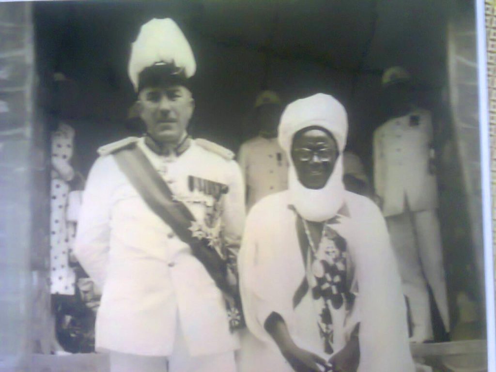
Along the line, the Federal Government again requested that the Emirate Council give up the name ‘Abuja’ to be used for the new Federal Capital Territory. The council was divided on this issue but eventually accepted the request, with a belief that the name ‘Abuja’ would become famous around the world.
Abuja was then created and became the capital city of Nigeria. The old town of Abuja was renamed ‘Suleja’ after the then Emir Suleiman Barau. ‘Sule’, the first syllable, was added from the Emir’s name while ‘Ja’, the last syllable, was added from the name of the first king.
1976 Decree & Establishment of FCT
In 1976, General Murtala Mohammed made this statement regarding moving the capital city as part of his broadcast:
“The area is not within the control of any of the major ethnic groups in the country. We believe that the new capital created on such virgin lands, as suggested, will be for all Nigerians a symbol of their oneness and unity. The Federal Territory will belong to all Nigerians. To avoid land speculation in the area, a decree is being promulgated immediately to vest all land in the Federal Territory to the Federal Government.”
General Mohammed ended his broadcast by proclaiming a new era of “justice, peace, and unity” in the country. Unfortunately, he didn’t live long enough as he was assassinated just seven days later. But his vision of the new central capital city lived after him.
Decree 6 of 1976 was promulgated on February 4, 1976, and the Federal Capital Territory of Abuja was established.
Designing the New City
The Federal Capital Territory was physically located in the centre of the country and viewed as neutral — culturally, ethnically, and religiously.
As a new city, Abuja had the advantage of being well-planned, with excellent road networks, beautiful streets, and adequate social amenities.
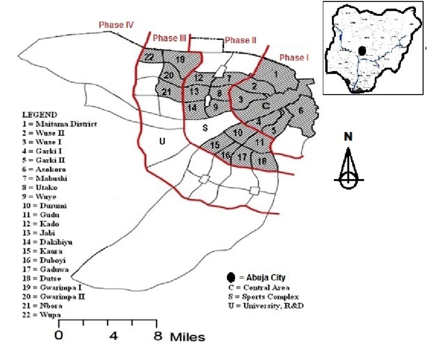
The Federal Capital Development Authority (FCDA) was the government agency set up to plan and develop the city. A competition for the design of Abuja was held and won by International Planning Associates (IPA), a consortium of three American planning and architecture firms.
IPA became responsible for extensively designing the city according to a master plan while taking advantage of the terrain’s contours.
Two phases were initially planned to be built: a central zone with government buildings and cultural institutions on broad avenues, and a residential and shopping zone.
Construction started in 1980. Government facilities were gradually built and public infrastructure such as water supply, airports, schools, health care facilities, and public transport was introduced.
By 1987, water, schools, and telephone systems to accommodate a million people were in place. A university was founded in 1988. The city was a great success and people migrated into the area rapidly.
“Centre of Unity” was adopted as the territory’s motto/slogan to serve as a constant reminder that Abuja was chosen in the hope of creating a united central city.
By 1991, the FCT had been developed to an appreciable level. And on 12 December 1991, Abuja replaced Lagos as the official capital city of Nigeria. The official transition happened under the leadership of General Ibrahim Badamosi Babangida (1985 – 1993).
Geographical Description of Abuja
The geographical description of the land area that makes up the Federal Capital Territory of Nigeria starts from the village Izom on 7 E longitude and 9 15’ latitude, projected a straight line westwards to a point just North of Lefu on the Kemi River; then project a line along 6 47½’ E southwards passing close to the villages called Semasu, Zui, and Bassa down to a place a little west of Ebagi, thence project a line along parallel 8 27½’ North latitude to Ahinza village 7’ E (on Kanama River); thence project a straight line to Bugu village on 8 30’ North latitude and 7 20’ E longitude; thence draw a line northwards joining the village of Odu, Karshi, and Karu. From Karu, the line should proceed along the boundary between the North-west and Benue-Plateau (Nassarawa) State as far as Karu; thence, the line should proceed along the boundary between North central (Kaduna) and Northwestern (Niger) States up to the point just north of Bwari village; thence the line goes straight to Zuba village; and thence straight to Izom.
FAQs on the History of Abuja
Here are some frequently asked questions about the history of Abuja, FCT.
How was Abuja formed?
What is the full meaning of Abuja?
What is the motto of Abuja?
What is the brief history of Abuja?
Conclusion on the History of Abuja
Abuja became the official capital of Nigeria on 12 December 1991 after it was carved out of present-day Niger state, Nasarawa state, and Kogi state. The city was built in phases according to a master plan developed in the 1980s.
Today, it is one of the fastest-growing cities and has witnessed an influx of people in recent times leading to the emergence of satellite towns such as Karu, Nyana, Suleja, Gwagwalada, and Kuje.
The presence of various governmental institutions, businesses, and foreign embassies has led to significant growth and investment in the city. Abuja shares borders on the north with Kaduna State, on the southeast with Nasarawa State, on the southwest with Kogi State, and on the west with Niger state.
FACT CHECK: We strive for accuracy and fairness in our content curation and reporting.If you see something that doesn't look right, please don't hesitate to contact us!
JOIN COMMUNITY: Loved this post? You'll love our community more. Feel free to join our WhatsApp community today and be prepared to discover all of Abuja's best-kept secrets!