- India
- International
Friday, May 24, 2024
Journalism of Courage
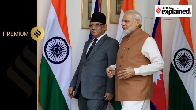 Nepal’s Prime Minister Pushpa Kamal Dahal Prachanda with Indian Prime Minister Narendra Modi in 2016. (Express photo by Prem Nath Pandey)
Nepal’s cabinet last week decided to put a map on its Rs 100 currency note showing certain areas administered by India in Uttarakhand as part of its territory, provoking External Affairs Minister S Jaishankar to say that such “unilateral measures” by Kathmandu would not change the reality on the ground.
The territorial dispute is about a 372-sq-km area that includes Limpiadhura, Lipulekh, and Kalapani at the India-Nepal-China trijunction in Uttarakhand’s Pithoragarh district. Nepal has claimed for long that these areas belong to it both historically and evidently.
The map was adopted by consensus in Nepal’s Parliament four years ago. The Prime Ministers of India and Nepal have agreed to have the boundary issue examined and settled through diplomatic channels. Following the Nepal cabinet’s decision, Jaishankar said on May 4 that “discussions about our boundary matters [are ongoing] through an established platform”, but it would appear that Kathmandu is not happy with the pace and urgency of that process.
Unlike in 2020, when the new map was adopted, the May 2 decision to put it on the currency note has met with scepticism and criticism in Nepal.
The Treaty of Sugauli at the end of the Anglo-Nepalese War of 1814-16 resulted in Nepal losing a chunk of territory to the East India Company. Article 5 of the treaty took away the jurisdiction of Nepal’s rulers over the land to the east of the Kali River.

Buddhi Narayan Shrestha, an expert on boundaries, said that maps issued by the British Surveyor General of India in 1819, 1821, 1827, and 1856 showed the Kali River as originating in Limpiadhura. The next map, published in 1879, used the name of the river in the local language: “Kuti Yangti”.
The map that was published in 1920-21 retained the name Kuti Yangti — but it identified a different “Kali”. This new Kali was shown as a stream originating from a temple site, and joining the main stream about a kilometre downstream. However, the last map issued by the British before they left India in 1947 showed the initial position of the Kali River originating in Limpiadhura, Shrestha said.
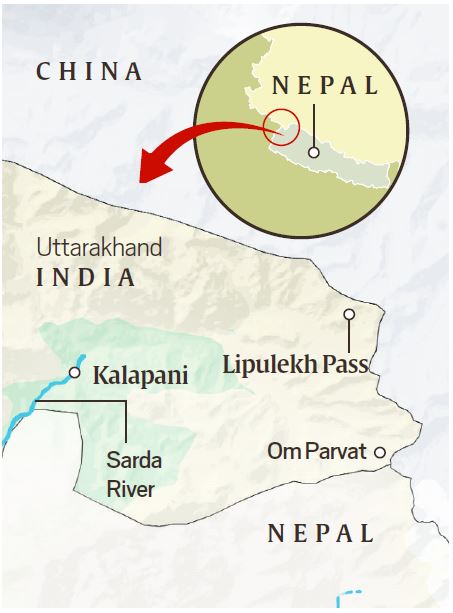 Map showing Kalapani, Lipulekh and India-Nepal border.
According to Shrestha, villages in this area — Gunji, Nabhi, Kuti, and Kalapani, also known as Tulsi Nyurang and Nabhidang — were covered by the Nepal government census until 1962, and the people paid land revenue to the government in Kathmandu. However, the situation changed after the war between India and China that year.
Bishwabandhu Thapa, a former Home Minister of Nepal who is now 93, said India’s Prime Minister Jawaharlal Nehru approached King Mahendra of Nepal asking for permission to use Kalapani, which was strategically located close to the trijunction, as a base for the Indian Army.
Dr Bhekh Bahadur Thapa, who served as Nepal’s Foreign Minister in 2005-06 and as Ambassador to India during 1997-2003, said that even though Indian officials claimed in bilateral talks later that King Mahendra gifted the area to India, the issue was never resolved.
Several prominent personalities who have officially represented Nepal in bilateral talks claimed that Prime Minister I K Gujral (April 1997-March 1998) had promised to give up these areas if Nepal was able to produce evidence for its claim.
In July 2000, Prime Minister Atal Bihari Vajpayee assured the visiting Nepal PM G P Koirala that India had no interest in even an inch of Nepali territory — however, the mechanism led by the two foreign secretaries did not make progress.
The visit of Prime Minister Narendra Modi to Nepal in 2014 gave rise to hopes of a resolution of all contentious issues. He and his Nepali counterpart, Sushil Prasad Koirala, agreed to set up a boundary working group for speedy settlement of the border issue in Kalapani and Susta, a 145-sq-km area that had fallen on the Indian side after the River Gandak changed course.
After returning from India on June 3 last year, Nepal’s Prime Minister Pushpa Kamal Dahal Prachanda claimed that Modi had assured him that the border issue would be sorted out at the earliest; however, there was no mention of this in the official statement at the end of the official visit.
The goodwill of the 2005-14 period when India mediated the transition of the Hindu Kingdom into a secular federal republic, evaporated in 2015 after the Maoists rejected outright the suggestion of New Delhi, conveyed through then Foreign Secretary Jaishankar, that Nepal’s new constitution should be delayed until the concerns of the Terai parties were addressed.
The 134-day blockade of Nepal that began in September 2015 created significant distrust against India, and K P Sharma Oli, who took over as Prime Minister that October, quickly moved to sign a trade and transit agreement with China in order to create a fallback source for the supply of essential goods.
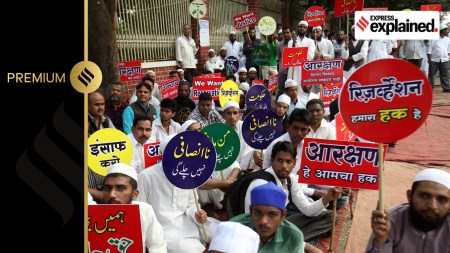
In February 2018, Oli, chairman of the Communist Party of Nepal (Unified Marxist Leninist), returned as Prime Minister with a massive mandate in the first election held under the new constitution. In 2020, he took the lead to build the consensus in Parliament for Nepal’s new map that formally included the 372 sq km in Uttarakhand, and pledged to bring it back.
India decried Nepal’s “cartographic aggression” as unacceptable, but said the issue would have to be sorted out through diplomatic channels, on the basis of evidence. It is noteworthy that the cabinet decision on printing the new Rs 100 notes has come less than two months after Oli’s party joined the ruling coalition in Nepal.
While the manifesto of Oli’s CPN (UML) promised to bring these areas into Nepal, successive governments in Kathmandu have over the years taken up issues of “border encroachment” with both India and China, Rajeshwar Acharya, Nepal’s former Ambassador to China, said.
Unlike 2020, when the new map was adopted by Parliament, there is no visible consensus on putting the map on the currency note. The UML and Prachanda’s CPN (Maoist Centre) are together in the ruling coalition, but the Nepali Congress, the main opposition and largest party in Parliament, is yet to make a statement on this issue.
Chiranjivee Nepal, economic advisor to President Ram Chandra Poudel and a former Governor of Rashtra Bank, Nepal’s central bank, has described the cabinet decision as “unwise” and “provocative”. Many others, too, believe the issue should be settled through dialogue without actions that may invite extreme steps by India. However, based on a preliminary assessment, the government appears hopeful that with better road connectivity with China, the hardships of Nepalis in the event of a 2015-like blockade will be far less.
Nepal sorted out its boundary issues with China in the early 1960s through bilateral meetings of the boundary commission. Nepal’s former Prime Minister Kirtinidhi Bista had once quoted his Chinese counterpart Chou En-lai as saying that border issues, if left unresolved, turn into problems for the future generations that are difficult to address.
Despite the in-principle agreement on resolution through appropriate platforms based on evidence, India and Nepal have not fixed a timeframe or called a meeting for the purpose.

UPSC Key | Buffer stock, PLI, NATO and moreSubscriber Only

How joblessness in India has hurt all communities over lastSubscriber Only

Journey of a political meme: From digital war room toSubscriber Only

OpenAI’s GPT-4o has some insane capabilities: 7 use casesSubscriber Only
Former WHO chief scientist at Idea ExchangeSubscriber Only