Abuja serves as the capital of Nigeria and the Federal Capital Territory (FCT), located in the centre of the country.
It is one of the wealthiest urban areas in Africa, playing home to some of the richest people on the continent.
Abuja was built according to a master plan developed in the 1980s and it replaced Lagos as Nigeria’s official capital on 12 December 1991.
Over the years, Abuja has witnessed huge population growth which has led to the emergence of satellite towns such as Karu, Nyana, Suleja, Gwagwalada, and Kuje.
The presence of numerous governmental institutions, businesses, and foreign embassies has led to significant growth and investment in the city. This made the area rank high among the fastest-growing cities globally.
Abuja shares borders on the north with Kaduna State, on the southeast with Nasarawa State, on the southwest with Kogi State, and on the west with Niger State.
The territory is nicknamed “The Centre of Unity” which serves as its motto or slogan.
History of Abuja
Abuja sits on land originally the southwestern part of the ancient Habe (Hausa) kingdom of Zazzau (Zaria).
For centuries, this land was populated by several semi-independent tribes: Hausa, Gbagyi Koro, and other small tribes. The largest of these tribes was Gbagyi (Gwari).
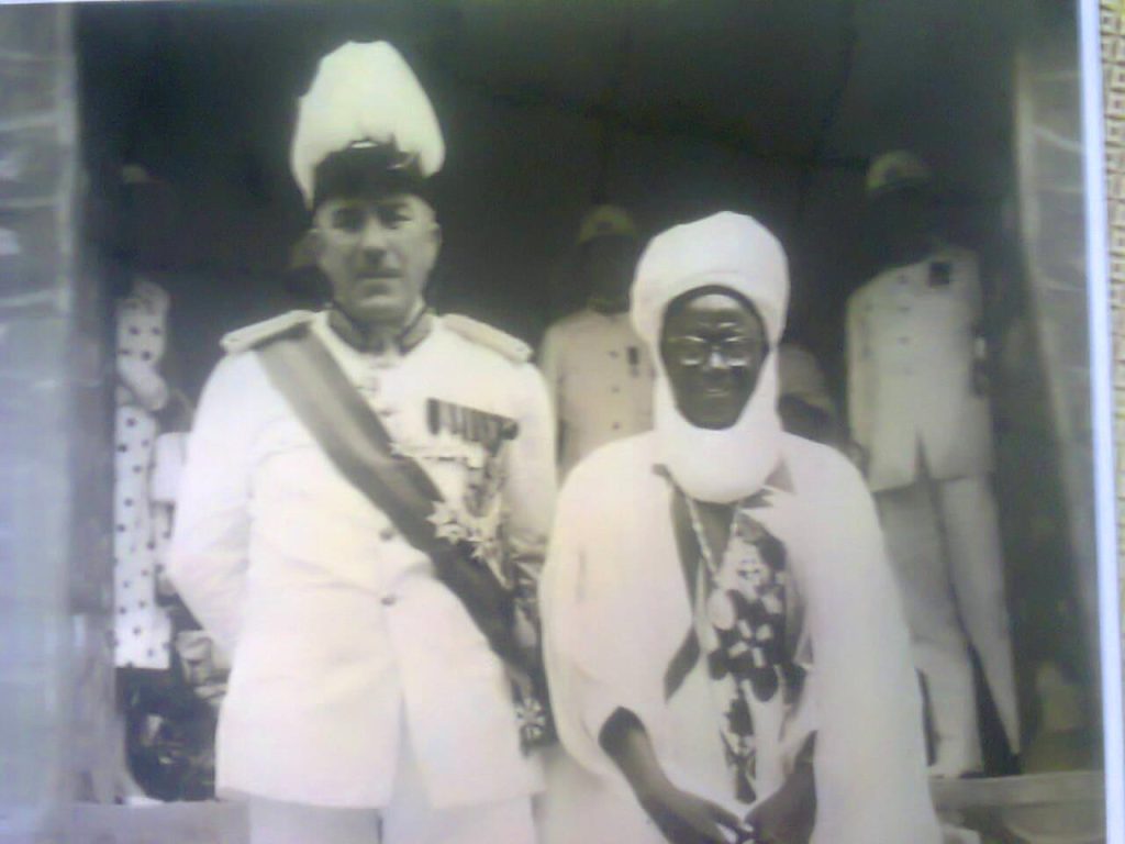
When Fulani invaders raided the city and took Zaria in the early 1800’′s, Muhammed Makau fled south with his brothers (Abu Ja and Kwaka) and some followers. In 1825, Abubakar (Abu Ja) succeeded Muhammed Makau as king and founded the kingdom of Abuja.
The king of Abuja’s first name was Abubakar and his nickname was Abu. So how did the ‘Ja’ come about?
Some accounts reported that his light complexion earned him the nickname Abu-Ja since ‘Ja’ means red or light-skinned in Hausa. In this case, Abu-Ja means “Abu the red” or “Abubakar the fair one”. Other historical accounts say that the ‘Ja’ was shortened from lshaku Jatau, his father’s name.
Under the rule of King Abubakar, Abuja rose to become a major commercial and trade center where goods were exchanged by long-distance traders. The Fulani invaded but the inhabitants of Abuja successfully fought the invaders off. Abuja was l not conquered as the neighbouring lands were.
In 1902, the kingdom of Abuja was occupied by the British colonial army. The army reorganized the kingdoms and called them ‘Emirates’ which means kingdoms in Arabic. And from then till 1975, Abuja remained a quiet, inactive part of Nigeria.
Relocation of capital from Lagos
Lagos, which was the capital city of Nigeria at the time, had several problems associated with being the capital. Population pressures and ethno-political necessitated a move from Lagos.
These led to the search for a new capital city and Abuja was among 33 possible sites. Abuja was eventually chosen for ticking many boxes on the criteria list including land availability, centrality, health, climate, good soil topography, water supply, multi-access possibilities, security, the existence of resources, drainage, physical planning convenience, and ethnic accord.
Altai Suleiman Barau was the Emir of Abuja at the time and he was tasked by the Federal Government to meet with his Emirates Council and secure approval for using four of the five districts in old Abuja to form the new capital.
The Emirate Council was divided on this request as some districts considered it too much of a sacrifice. But eventually, they agreed and approved the request. Now, the new federal capital territory was formed with 80% of land from Niger State, 16% of land from Plateau State (now Nasarawa State), and 4% from Kwara State (now Kogi State).
Again, the Federal Government requested that the Emirate Council give up the name ‘Abuja’ to be used for the new Federal Capital Territory. The council was initially divided on this issue but eventually accepted the request, with a belief that the name ‘Abuja’ would become famous around the world.
Abuja was then created and became the federal capital city of Nigeria. The old town of Abuja was renamed ‘Suleja’ after the then Emir Suleiman Barau. ‘Sule’, the first syllable, was added from the Emir’s name while ‘Ja’, the last syllable, was added from the name of the first king.
Based on tradition, the original inhabitants of Abuja lived at the base of the rock for centuries without being conquered. For them, the rock was a refuge as well as a mystical source of strength. Aso Koro, which was the name of one of the local areas, means ‘people of victory’. And today, the term Aso Rock is used to refer to the physical structure of the most imposing rock in Abuja and a symbol of government power as well.
On February 4, 1976, a decree was signed and the Federal Capital Territory of Abuja was established. The Federal Capital Development Authority (FCDA) was also set up as the organization responsible for developing the city. It would later take 15 years before the seat of government was moved.
The new capital city was physically located in the centre of the country and viewed as neutral — culturally, ethnically, and religiously. The motto for the Federal Capital Territory was “Centre of Unity”, serving as a constant reminder that Abuja was chosen in the hope of creating a united central city.”
As a new capital, Abuja had the advantage of being well-planned, with excellent road networks, beautiful streets, and adequate social amenities.
Population
Abuja is one of the fastest-growing cities in Africa and the world. With a total population of well over 2.5 million, Abuja currently has the 4th biggest metropolitan population in Nigeria after Lagos, Kano, and Ibadan.
The 2006 national census puts the population of Abuja at over 1.4 million. However, the city experienced a rapid population increase of almost 140% in the early 2000s.
This growth can be connected to the city’s status as Nigeria’s capital city and its reputation for being welcoming to all groups, no matter their ethnicity or religion.
Weather & Climate
Abuja experiences two annual weather conditions, just like in the tropics. These are the rainy season (winter) and the dry season (summer).
The rainy season in Abuja mostly starts in April and ends in October. During this period, there is a brief interlude of harmattan occasioned by the trade wind coming from the North East. This wind mainly has features such as dryness, dust haze, and intensified coldness.
The high altitudes and undulating terrain of the region, fortunately, moderate and influence the weather of the territory. Temperature ranges from 25C to 30C, making swimming a good idea on some days.
Rainfall in Abuja reflects the region’s location towards the windward side of the Jos Plateau and the zone of rising air masses. The annual total rainfall is in the range of 1100mm to 1600mm.
Vegetation
The Federal Capital Territory falls within the Savannah Zone vegetation of West Africa. You will find patches of rainforest, especially in the gullied train to the south and the rugged southeastern parts of the territory.
These areas of Abuja form one of the surviving occurrences of mature forest vegetation in Nigeria.
Demographics & Culture
Being a planned city and strategically situated city, Abuja is home to multiple cultures and religions.
The city was built to bring together all tribes, religions, ethnic groups, and identities in Nigeria. It was designed to be safe, united, and peaceful for all.
English is the official language spoken in Abuja. However, other major Nigerian languages such as Hausa, Yoruba, Fulani, and Igbo are spoken.
Ethnic groups you’ll find in the city’s diverse population include Hausa, Afo, Gwari, Koro, Bassa, Yoruba, and Igbo to name a few.
Some mineral resources found in the area include tin, clay, gold, iron ore, lead, marble, and talc.
Administration
The Federal Capital Territory Administration (FCTA) is the ministry responsible for the management and administration of Abuja and the Federal Capital Territory of Nigeria.
FCTA was created by ex-President Olusegun Obasanjo on December 31, 2004, after the previous Ministry of the Federal Capital Territory (MFCT) was scrapped.
To oversee the affairs of the ministry, an FCT Minister is usually appointed by the President, assisted by a Permanent Secretary. The current FCT minister is Nyesom Wike Ezenwo.
The Federal Capital Development Authority (FCDA) operates under FCTA and was set up to manage the building and infrastructural development of the urban area.
Local Government Area Councils
The Federal Capital Territory (FCT) consists of six (6) local government area councils which are:
- Abaji Local Government Area
- Abuja Municipal Local Government Area
- Bwari Local Government Area
- Gwagwalada Local Government Area
- Kuje Local Government Area
- Kwali Local Government Area
These councils are subdivided into wards and cover a land area of about 7,290 km². Each council also has an administrative headquarters and an executive chairman to oversee its affairs.
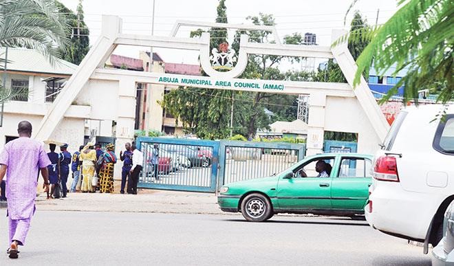
Abuja Municipal Area Council (AMAC) holds Nigeria’s political and administrative capital. It is an urbanized area council with a host of notable districts such as Garki, Jabi, Asokoro, Wuye, Utako, and Gwarinpa.
City Planning & Architecture
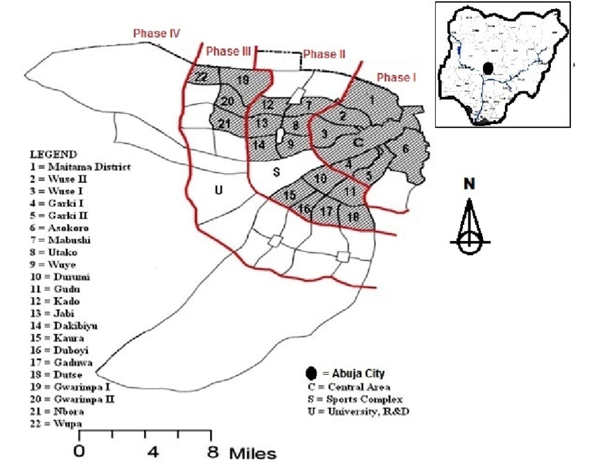
In 1979, a master plan was created for Abuja to be developed in five development phases covering a total of 1,000 sq km and a population estimate of 3 million by the year 2010.
These developmental phases — numbered from Phase 1 to Phase 5 — contain several districts for residential, governmental, or commercial purposes. Each of these districts also has neighborhoods.
This plan was done by the urban city planners for ease and coordination of developmental efforts.
Phase 1
Phase 1 houses Abuja’s most sought-after, affluent neighborhoods and is divided into five (5) districts.
Districts under Abuja Phase 1 include Asokoro, Central Area, Garki, Garki II, Guzape I, Guzape II, Maitama, Wuse, and Wuse II.
If you’re searching for beautiful real estate properties in exclusive neighborhoods that attract a premium, you shouldn’t look further than Abuja Phase 1.
The neighborhoods in this phase boast excellent infrastructure in place and an extensive interlinking road network.
Most administrative, government, leisure, and commercial activities also take place in this region.
Phase 2
Phase 2 is host to various districts that share a few qualities with those in Phase 1.
Here, you’ll find well-developed neighborhoods with a good level of infrastructure and a smooth road network.
Also, there are a host of several premium residential, commercial, and leisure spaces in this area.
Districts under Abuja Phase 2 include Apo-Dutse, Dakibiyu, Duboyi, Durumi, Gaduwa, Gudu, Jabi, Jahi, Kado, Katampe, Kaura, Kukwaba, Mabushi, Utako and Wuye.
Phase 3
Phase 3 is situated a bit further away from the city centre and is still undergoing development and transformation.
Most neighborhoods in this area have the basic infrastructure available with affordable properties and land for development. You’ll also find a ton of commercial activities going on in this area.
Districts in Phase 3 include Bunkoro, Dakwo, Dape, Galadimawa, Gwarinpa, Industrial Area, Kabusa, Kafe, Karmo, Life Camp, Lokogoma, Nbora, Okanje, Pyakasa, Saraji, Wumba, and Wupa.
Phase 4
Phase 4 has not witnessed any substantial development since the developmental plan of Abuja began.
There’s a lack of basic infrastructure in the area. And even though a lot of land in the region has been allocated for various purposes, construction is yet to begin.
Districts in Phase 4 include Bude, Burun, Chafe, Gidari Bahagwo, Gwagwa, Gwari, Idogwari, Idu, Jaite, Kaba, Kagini, Karsana, Ketti, Kpoto, Mamusa, Parfun, Sabo Gida, Sheretti, Tasha and Waru-Pozema.
Phase 5
Phase 5 consists of many satellite towns in areas near Abuja’s airport road. Districts in Phase 5 include Kyami and Lugbe.
Suburban Districts
There are also five suburban districts that are not part of the original Abuja master plan. However, due to the proximity to the capital city, some measures of development have occurred in these areas.
Notable suburban districts around Abuja include Kubwa, Nyanya, Karu, Kuje, Jikwoyi, Mpape, and Dawaki.
Landmarks
Abuja plays host to a plethora of notable national monuments and landmarks. Some of these landmarks include:
- Presidential Complex
- Three Arms Zone
- National Assembly
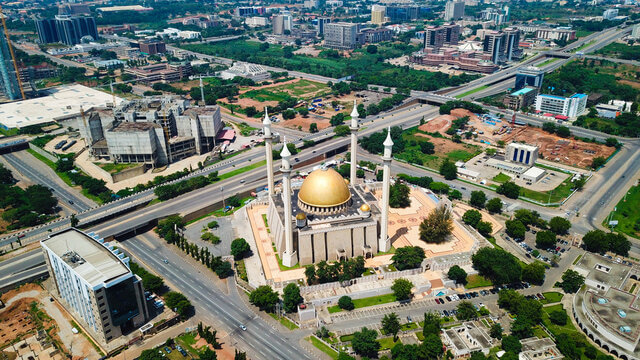
- Nigerian National Mosque
- Millennium Park
- Jabi Lake
- Eagles Square
- The Nigerian National Christian Centre
- And any more
Many diplomatic missions have their embassies in Abuja while others have their permanent structures being built.
The main source of water for Abuja flows from the Usman Dam. And the digital telecommunications system is maintained by Nigeria Telecommunications Limited (NITEL) and other privately owned satellite and telecommunications systems.
Lastly, Abuja is the headquarters of the Economic Community of West African States or ECOWAS. It also has the regional headquarters of OPEC.