Housing guide: Where to live in the Peninsula
From Daly City's gorgeous shoreline to Palo Alto's cultural draws, there's more than tech in Silicon Valley
The peninsula that divides the San Francisco Bay from the Pacific Ocean is bounded in the north by San Francisco and in the south by San Jose, but when locals talk about “the Peninsula,” they’re referring to the region just south of San Francisco that encompasses all of San Mateo County plus the northern reaches of Santa Clara County. Comprising a large chunk of Silicon Valley, the Peninsula is often associated with tech and innovation, but those who call it home know there’s much more to the area, from Pacifica’s captivating coastline to Redwood City’s chic town square and Palo Alto’s renowned cultural institutions.
The county seat of San Mateo is Redwood City, whose downtown features an archway that boasts of “Climate Best by Government Test,” a city slogan that dates back nearly a century. Indeed, with a landscape that includes beaches, forests and mountains, sunshine and outdoor pursuits are draws for many Peninsula residents. Locals enjoy paragliding at Mussel Rock Park in Daly City, hiking along Skyline Ridge, cycling past Crystal Springs Reservoir on a scenic stretch of Cañada Road or horseback riding in bucolic Woodside. Prefer to be a spectator? Mavericks Beach is a legendary destination for big-wave surfers, with a prestigious winter contest held whenever conditions are right. In addition to its own sports teams, Stanford University hosts special events such as the California Clásico, a matchup between Major League Soccer rivals the San Jose Earthquakes and L.A. Galaxy.
The character of the cities and towns dotting the Peninsula varies greatly. There are slices of suburbia where tract housing and big-box stores are prevalent, more rural locales with a small-town feel and everything in between. Most are considered family-friendly, with many offering well-regarded public and private schools and easy access to parks and recreational facilities. Downtowns and business plazas are filled with retailers, restaurants and offices, and cultural attractions range from quirky (the 92-foot-tall wind harp in South San Francisco by Lucia and Aristides Demetrios) to world-renowned (the Rodin Sculpture Garden at Stanford). Mid-century architecture buffs should keep an eye out for modernist residences by Henry Doelger (which populate the Westlake neighborhood of Daly City) and Joseph Eichler (who built farther south on the Peninsula, with his largest development in the San Mateo Highlands).
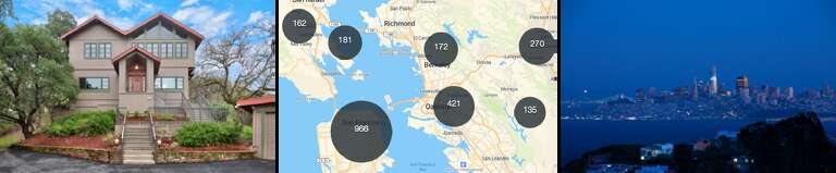
Select towns and cities below to learn about the Peninsula area
And then there’s tech. The Peninsula is home to headquarters for Genentech, Facebook, Tesla and Google (to name just a few), as well as high-profile venture capital firms along the famous Sand Hill Road in Menlo Park — and many of the startups they fund.
From the Peninsula, the commute to San Francisco is served by two major freeways, I-280 and U.S. Route 101, as well as two train systems, BART and Caltrain, running as far south as San Jose and Gilroy, respectively. (Prior to the pandemic, many tech workers coming from San Francisco into the heart of Silicon Valley took advantage of company buses that shuttled them between home and the office.) Not quite as fast as the train systems is SamTrans, with public bus lines traversing the coast and the business hubs of the Peninsula.
Advertisement
Find your ideal neighborhood
Daly City
Pastel homes trace the hills just south of San Francisco
Why you’ll love it
 Commuter's dream
 Waterfront
 Low-cost living
data dive
| Key Facts | Daly City | California |
|---|---|---|
| Population | 106,677 | 39,512,223 |
| Median household income | $94,550 | $75,235 |
| Median home value | $783,400 | $505,000 |
| Median rent | $2,220 | $1,503 |
| Avg. commute (mins.) | 30.8 | 29.8 |
The neighborhood

Convenience is king in the northernmost city in San Mateo County, which offers super-easy access to San Francisco by car or public transit. Like its urban neighbor, Daly City boasts Pacific coastline and the same seemingly ever-present fog, too.
While there’s no true downtown to speak of, a wide array of stores and restaurants populate its outdoor malls and shopping centers — among them, Serramonte, which is also home to a twice-weekly farmers’ market and a weekly Off the Grid food-truck gathering.
The housing — a combination of apartments, condos and the colorful single-family post-war homes that inspired the song “Little Boxes” — is denser here than in other parts of the Peninsula, making Daly City the largest city in San Mateo County. Twelve elementary schools feed into four middle schools and two high schools (there’s also Summit Shasta, a charter high school). Since 1941, Daly City’s Cow Palace has hosted the annual Grand National Rodeo (including a virtual iteration in 2020).
the schools
| School District | Enrollment | Graduation Rate |
|---|---|---|
| jefferson union high | 4,342 | 89.2 |
Advertisement
Redwood City
A tech center with a revitalized town square
Why you’ll love it
Waterfront Arts and culture
 Food lover's hub
data dive
| Key Facts | Redwood City | California |
|---|---|---|
| Population | 85,784 | 39,512,223 |
| Median household income | $117,123 | $75,235 |
| Median home value | $1,251,000 | $505,000 |
| Median rent | $2,355 | $1,503 |
| Avg. commute (mins.) | 26.5 | 29.8 |
The neighborhood

Once dubbed the “Chrysanthemum Capital of the World” — thanks to brothers Eikichi and Sadakusi Enomoto cultivating the flowers here in the early 1900s — Redwood City has also been known for leather tanning and lumber. More recently, it has attracted big names in tech like Oracle and Box and their employees.
A downtown revitalization in 2006 restored historic Courthouse Square, which now hosts art festivals and movie screenings, as well as the Fox Theatre, a huge events space. New-ish spots such as La Viga Seafood & Cocina Mexicana, Gambrel & Co. craft butchery and Vesta (whose pizzas landed on Michelin’s Bib Gourmand guide) have joined decades-old restaurants like Gourmet Haus Staudt and Talk of Broadway. Thirteen schools make up the Redwood City School District, which includes Spanish and Mandarin immersion programs and McKinley Institute of Technology. In addition to two public high schools, charter schools Design Tech and Summit Prep are located in Redwood City. Cañada College, a community college in the western part of the city, has a noteworthy STEM program.
the schools
| School District | Enrollment | Graduation Rate |
|---|---|---|
| sequoia union high | 9,052 | 87.4 |
Advertisement
San Mateo
Natural gems and transit stops halfway down the Peninsula
Why you’ll love it
Commuter's dream Parks
Parks Retail haven
data dive
| Key Facts | San Mateo | California |
|---|---|---|
| Population | 104,333 | 39,512,223 |
| Median household income | $124,842 | $75,235 |
| Median home value | $1,098,400 | $505,000 |
| Median rent | $2,475 | $1,503 |
| Avg. commute (mins.) | 29.1 | 29.8 |
The neighborhood

Situated about halfway between San Francisco and San Jose with three Caltrain stations shuttling workers in either direction, San Mateo can feel a world away from city life. Even its charming downtown is next to Central Park, a 16-acre oasis that includes the Japanese Garden and seasonal mini-train. The city is also home to Sawyer Camp Trail — adjacent to Crystal Springs Reservoir, with six miles of paved trail for stroller-pushers and cyclists — and Coyote Point Recreation Area, a 670-acre park along San Francisco Bay.
Hillsdale Shopping Center, a venue with more than 120 stores, is undergoing a massive update, and nearby, former racetrack Bay Meadows is now a mixed-use development with housing, retail and offices. The San Mateo-Foster City School District includes 16 elementary schools and three middle schools, along with North Shoreview Montessori and STEAM-focused Bayside Academy. There are three public high schools, and College of San Mateo, a community college, draws students from all over the county.
the schools
| School District | Enrollment | Graduation Rate |
|---|---|---|
| san mateo union high | 9,314 | 93.8 |
Menlo Park
Artistic institutions and burgeoning development in Menlo Park
Why you’ll love it
WaterfrontParksArts and culturedata dive
| Key Facts | Menlo Park | California |
|---|---|---|
| Population | 34,138 | 39,512,223 |
| Median household income | $160,784 | $75,235 |
| Median home value | $2,000,001 | $505,000 |
| Median rent | $2,341 | $1,503 |
| Avg. commute (mins.) | 26.6 | 29.8 |
The neighborhood

Named after the Irish village of Menlough, a quick look at this mid-Peninsula city’s El Camino Real and the area around the Menlo Park Caltrain station reveals that big changes are coming. Projects currently under development will yield more residential units, as well as office space, retail shops and restaurants. A block away, the Guild Theatre is set to become a highly anticipated, Ken Fulk-designed entertainment venue, and in the meantime, downtown is full of beloved local institutions. Pick up a book at Kepler’s and a coffee at Café Barrone next door, then enjoy both alfresco by the fountain. Nearby Allied Arts also features retail spaces along with artists’ studios in a beautiful garden setting. Ten-acre Sharon Park is another outdoor draw.
Residents are served by the Los Lomitas and Menlo Park City school districts, which have a combined four elementary and two middle schools. There are three local high schools: Menlo-Atherton, TIDE Academy and Mid-Peninsula. Facebook is a major employer, and its Menlo Park headquarters, complete with giant thumbs-up sign, has even become a tourist attraction.
the schools
| School District | Enrollment | Graduation Rate |
|---|---|---|
| sequoia union high | 9,052 | 87.4 |
Burlingame
Bayfront parks and tech headquarters beckon in Burlingame
Why you’ll love it
WaterfrontParks Small-town feel
data dive
| Key Facts | Burlingame | California |
|---|---|---|
| Population | 30,576 | 39,512,223 |
| Median household income | $128,447 | $75,235 |
| Median home value | $1,901,900 | $505,000 |
| Median rent | $2,210 | $1,503 |
| Avg. commute (mins.) | 30.4 | 29.8 |
The neighborhood

Incorporated in 1908 as San Franciscans decamped after the 1906 earthquake, Burlingame remains a desirable place to live thanks to its pair of Caltrain stops, proximity to San Francisco and SFO, and a range of single-family homes, condos and apartments that appeals to buyers and renters alike.
The public school system includes six elementary schools, Burlingame Intermediate School and two high schools. A pair of commercial districts are anchored by pedestrian-friendly thoroughfares Broadway and Burlingame Avenues, with a mix of independent and national outfits. Of the former, Preston’s Candy & Ice Cream, founded in 1946, is a must-visit. Located along the San Francisco Bay, the new Bayfront Park (opened in February 2021 near Oculus’ 800,000-square-foot headquarters) is ideal for scenic strolls and picnics, while Anza Lagoon caters to more athletic endeavors like running and biking. The regular Fresh Market features food and crafts purveyors as well as live music, while Kohl Mansion (a 107-year-old mansion and wedding venue on the National Register of Historic Places) offers chamber concerts and education programs.
the schools
| School District | Enrollment | Graduation Rate |
|---|---|---|
| san mateo union high | 9,314 | 93.8 |
Palo Alto
Destination restaurants and robust retail a stone's throw from Stanford University
Why you’ll love it
Arts and cultureParksFood lover's hubdata dive
| Key Facts | Palo Alto | California |
|---|---|---|
| Population | 66,573 | 39,512,223 |
| Median household income | $158,271 | $75,235 |
| Median home value | $2,000,001 | $505,000 |
| Median rent | $2,569 | $1,503 |
| Avg. commute (mins.) | 25.5 | 29.8 |
The neighborhood

Palo Alto residents choose the mid-Peninsula city for its cultural attractions (like Stanford University’s Cantor Arts Center and Bing Concert Hall), convenient access to campus and the public schools — including 12 elementary schools, three middle schools and two high schools (one of which features a well-known media training lab). The popular walking trails around Stanford’s “The Dish” have multiple entry points, and a lesser-known campus highlight is the cactus garden (not far from the mausoleum where the school’s founders and their son, for whom the university is named, are buried).
Stanford Shopping Center delivers a mix of retailers, from Everlane to Hermès, the California Avenue business district is filled with longstanding culinary favorites like La Bodeguita Del Medio, and old and new, cheap and chic coexist peacefully downtown. Grab coffee from Blue Bottle on University Avenue; lunch at Stanford’s Cantor Café overlooking the Rodin Sculpture Garden; and dinner at Michelin-starred Protégé, from a couple of French Laundry alums. A number of big-name companies were founded in Palo Alto and many are still headquartered here, including Tesla and VMware.
the schools
| School District | Enrollment | Graduation Rate |
|---|---|---|
| palo alto unified | 11,745 | 96.0 |
Woodside
Pastoral San Mateo County means horse stables and sprawling estates
Why you’ll love it
ParksSmall-town feeldata dive
| Key Facts | Woodside | California |
|---|---|---|
| Population | 5,542 | 39,512,223 |
| Median household income | $250,001 | $75,235 |
| Median home value | $2,000,001 | $505,000 |
| Median rent | $2,232 | $1,503 |
| Avg. commute (mins.) | 26.1 | 29.8 |
The neighborhood

Tucked into the interior of the Peninsula just off I-280, Woodside offers pastoral, often sprawling properties — think stables and even vineyards — along winding, wooded roads that Teslas share with cyclists and equestrians.
The Woodside School District is composed of an elementary and a middle school, while Woodside High School is in neighboring Redwood City (a number of private schools are located in the surrounding cities). A small commercial corridor near I-280 includes a handful of shops and restaurants, like local favorites Emily Joubert boutique and the Michelin-starred Village Pub (and its more casual sister, the Village Bakery).
Head into the hills for more remote living with easy access to great trails inside the 900-acre Huddart Park, beloved Alice’s Restaurant and the scenic Thomas Fogarty Winery. Filoli, a historic estate and garden, is among Woodside’s attractions, and art enthusiasts flock to special events at Runnymede Sculpture Farm and Djerassi Resident Artists Program, both of which are typically closed to the public.
the schools
| School District | Enrollment | Graduation Rate |
|---|---|---|
| sequoia union high | 9,052 | 87.4 |
Credits
Editing
Sarah Feldberg • sarah.feldberg@sfchronicle.com • @sarahfeldberg
Copy editing
Marty Cortinas • marty.cortinas@sfchronicle.com • @mindworm
Visuals editing
Guy Wathen • gwathen@sfchronicle.com • @guywathen
Nicole Fruge • nfruge@sfchronicle.com • @photofruge
Design and development
Yoli Martinez • yoli.martinez@sfchronicle.com • @yoli_martinez
Eric Blom • eric.blom@sfchronicle.com • @ejblom
Hilary Fung • hilary.fung@sfchronicle.com • @hil_fung
Danielle Mollette-Parks • dmollette-parks@sfchronicle.com • @daniellemparks