Exploring the Rivers of Europe: A Journey Through Nature’s Lifelines
This post may contain affiliate links. As an Amazon Associate, we earn from qualifying purchases.
Rivers are the lifelines of our planet, shaping landscapes, supporting ecosystems, and providing vital resources to communities. Europe is blessed with a vast network of rivers, totaling over 1.5 million kilometers in length. These rivers, big and small, flow through diverse landscapes, from the icy peaks of the Alps to the sprawling plains of Eastern Europe. The continent boasts some of the most iconic rivers in the world, including the Danube, Rhine, and Volga; among them, the Volga is the longest.
Longest Rivers in Europe
- Volga River – With a length of 3,692 kilometers, the Volga is Europe’s longest river. It flows through central Russia, serving as a crucial transport route and a source of livelihood for millions.
- Danube River – The Danube is Europe’s second-longest river, stretching 2,850 kilometers. It flows through ten countries, including Germany, Austria, Hungary, and Romania, before emptying into the Black Sea.
- Ural River – The Ural River runs for 2,428 kilometers, forming part of the border between Europe and Asia. It is an important waterway in Russia, supporting irrigation and industry.
- Dnieper River – Flowing 2,201 kilometers, the Dnieper River is one of the major rivers of Europe, traversing Russia, Belarus, and Ukraine. It is a vital source of water and energy for the region.
- Don River – The Don River extends for 1,950 kilometers, flowing through Russia and emptying into the Sea of Azov. It has played a significant role in Russian history and culture.
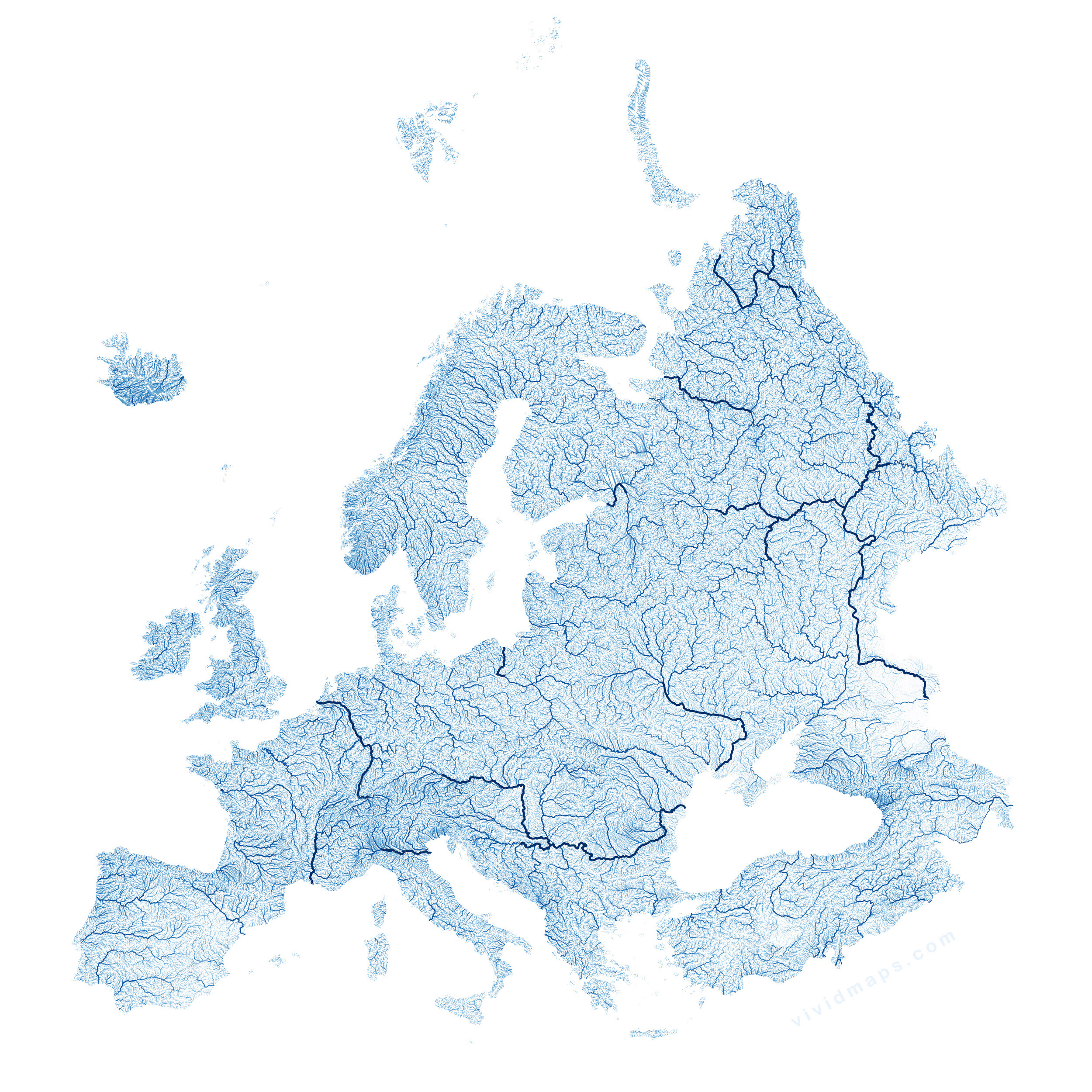
The density of the river network in Europe decreases from north to south. In Northern Europe, particularly in Scandinavia and the Baltic region, the density of rivers is relatively high. This is because of the presence of numerous lakes, wetlands, and a generally flat terrain, which facilitates the formation of many small rivers and streams.
As you move southward into Central Europe, the density of the river network decreases. The topography becomes more varied, with the presence of mountain ranges such as the Alps, the Carpathians, and the Pyrenees. These mountainous regions tend to have fewer rivers but often feature larger, more significant waterways that flow through valleys and gorges.
In Southern Europe, particularly in the Mediterranean region, the density of the river network is typically the lowest. The terrain is characterized by rugged mountains, plateaus, and arid landscapes, which are less conducive to the formation of rivers. The rivers that do exist in this region tend to be shorter and have more irregular flow patterns, often experiencing seasonal fluctuations in water levels. Here are the maps of the European rivers created by me using Hydrosheds data.
The longest rivers in Europe tend to have the largest basins as well. Below is the map of the river basins of European continent.


View the full-resolution versions of these map posters: 1, 2
Most Extensive River Basins in Europe
- Volga River Basin – The Volga River Basin is the largest river basin in Europe, covering over 1.3 million square kilometers. It is home to diverse ecosystems and supports a rich array of flora and fauna.
- Danube River Basin – The Danube River Basin is the second-largest river basin in Europe, spanning 801,463 square kilometers. It is a culturally and environmentally significant region, with numerous protected areas and heritage sites.
- Dnieper River Basin – The Dnieper River Basin is the third-largest river basin in Europe, covering 504,000 square kilometers. It is a vital source of water and energy for Ukraine and surrounding countries.
- Don River Basin – The Don River Basin is the fourth-largest river basin in Europe, spanning 422,000 square kilometers. It is a key agricultural region, known for its fertile soils and diverse crops.
- Rhine River Basin – The Rhine River Basin is the fifth-largest river basin in Europe, covering 185,000 square kilometers. It is a densely populated and industrialized region, with a rich cultural heritage.
Other Interesting Facts about European Rivers
- The Rhine River is one of the most important rivers in Europe, serving as a vital transport route and a source of water for millions of people.
- The Danube River is one of the most international rivers in the world, flowing through ten countries and serving as a cultural and historical landmark.
- The Seine River is one of the most picturesque rivers in Europe, flowing through the heart of Paris and offering stunning views of the city’s landmarks.
- The Rhine River Basin is one of the most densely populated river basins in Europe, with over 50 million people living in its watershed. It is a highly developed region, known for its industrialization and urbanization.
If you want to learn more about the rivers of Europe, you’ll find these books and maps fascinating.