Huntington Woods
Huntington Woods is a city in Oakland County in the U.S. state of Michigan. An inner-ring suburb of Detroit on the Woodward Corridor, Huntington Woods is located roughly 12 miles northwest of downtown Detroit.Photo: WeaponizingArchitecture, CC BY-SA 4.0.
- Type: Suburb with 5,900 residents
- Description: city in Oakland County, Michigan, United States of America
- Postal code: 48070
Notable Places in the Area
Royal Oak station
Railway station
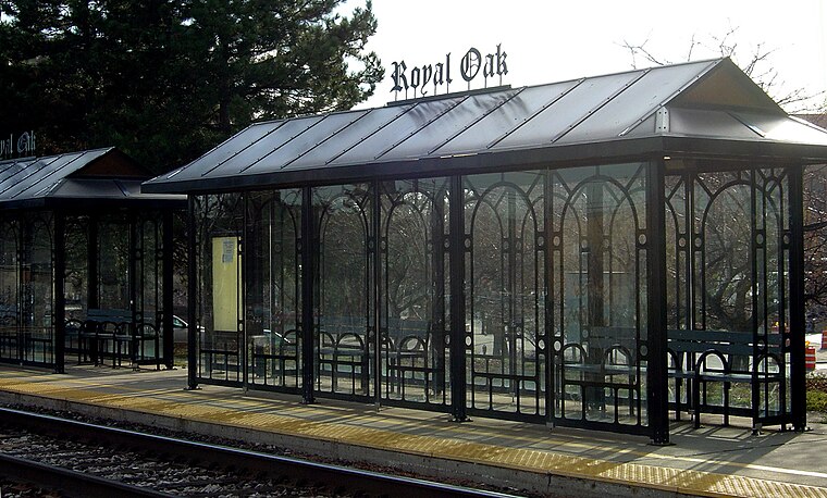
Photo: Stanthejeep, CC BY-SA 2.5.
The Royal Oak Transit Center is an intermodal transit station in Royal Oak, Michigan, a suburb of Detroit.
Dondero High School
School
George A. Dondero High School opened in 1927 in Royal Oak, Michigan in Greater Detroit.
Oak Park High School
School
Oak Park High School is a public high school located in Oak Park, Michigan an inner suburb of Detroit.
Localities in the Area
Royal Oak
Royal Oak is a suburb of Detroit in Oakland County, Michigan known for its trendy downtown shopping area and bars.Oak Park
Suburb
Photo: Johnrozsa, CC BY-SA 4.0.
Oak Park is a city in Oakland County in the U.S. state of Michigan. Oak Park is situated 1½ miles southwest of Huntington Woods.
Huntington Woods
- Categories: city in the United States and locality
- Location: City of Huntington Woods, Oakland County, Michigan, Midwest, United States, North America
- View on OpenStreetMap
Latitude
42.48059° or 42° 28' 50" northLongitude
-83.16687° or 83° 10' 1" westPopulation
5,900Elevation
663 feet (202 metres)United Nations Location Code
US HGWOpen Location Code
86JRFRJM+67OpenStreetMap ID
node 154387260OpenStreetMap Feature
place=suburbHuntington Woods Satellite Map
© OpenStreetMap, Mapbox and Maxar
Also Known As
- Arabic: هنتنغتون وودز
- Asturian: Huntington Woods (Michigan)
- Asturian: Huntington Woods
- Azerbaijani: Hantinqton-Vuds
- Basque: Huntington Woods (Michigan)
- Basque: Huntington Woods
- Bulgarian: Хънтингтън Удс
- Cebuano: Huntington Woods
- Chechen: Гантингтон-Вудс (Мичиган)
- Chechen: Гантингтон-Вудс
- Chinese: Huntington Woods
- Chinese: 亨廷頓伍茲
- Chinese: 亨廷顿伍兹
- Danish: Huntington Woods
- Dutch: Huntington Woods
- Egyptian Arabic: هنتنجتون وودز
- English: Huntington Woods, MI
- English: Huntington Woods, Michigan
- English: The City of Homes
- French: Huntington Woods
- Greek: Αποτελέσματα αναζήτησηςΑποτελέσματα ιστούΧάντινγκτον Γουντς
- Hebrew: הנטינגטון וודס
- Iloko: Huntington Woods
- Irish: Huntington Woods
- Italian: Huntington Woods
- Kazakh: Xantïng
- Kazakh: Хантинг
- Kazakh: حانتىينگ
- Ladin: Huntington Woods (Michigan)
- Ladin: Huntington Woods
- Malagasy: Huntington Woods, Michigan
- Malagasy: Huntington Woods
- Min Nan Chinese: Huntington Woods
- Norwegian: Huntington Woods
- Norwegian Bokmål: Huntington Woods
- Persian: هانتینگتونوودز، میشیگان
- Polish: Huntington Woods
- Portuguese: Huntington Woods
- Russian: Хантингтон-Вудс
- Serbian: Хантингтон Вудс
- Serbo-Croatian: Huntington Woods, Michigan
- Serbo-Croatian: Huntington Woods
- Slovenian: Huntington Woods
- South Azerbaijani: هانتینقتونوودز، میشیقان
- Spanish: Huntington Woods
- Spanish: Huntington Woods (Míchigan)
- Tatar: Гантингтон-Вудс (Мичиган)
- Tatar: Гантингтон-Вудс
- Ukrainian: Гантінгтон-Вудс
- Urdu: ہنٹنگٹن ووڈز، مشی گن
- Volapük: Huntington Woods
- Welsh: Huntington Woods, Michigan
- Welsh: Huntington Woods
Other Places Named Huntington Woods
Localities in the Area
- BerkleySuburb, 2 miles northwest
- FerndaleSuburb, 2 miles southeast
- PembrokeNeighborhood, 2½ miles south
- Blackstone ParkNeighborhood, 3 miles south
- Garden HomesNeighborhood, 3 miles south
Landmarks in the Area
- Driving Range Tee BoxGrassland
- Scotia Lincoln ParkPark
- Chipping GreenGrassland
- Aardvark
- Statue ParkPark
Popular Destinations in Oakland County
Discover Auburn Hills, Pontiac, Troy and Royal Oak.
Escape to a Random Place
Discover other destinations in the world.
About Mapcarta. Thanks to Mapbox for providing amazing maps. Data © OpenStreetMap contributors and available under the Open Database License. Text is available under the CC BY-SA 4.0 license, excluding photos, directions and the map. Description text is based on the Wikipdia page Huntington Woods. Photo: WeaponizingArchitecture, CC BY-SA 4.0.