Enjoy fast, free delivery, exclusive deals, and award-winning movies & TV shows with Prime
Try Prime
and start saving today with fast, free delivery
Download the free Kindle app and start reading Kindle books instantly on your smartphone, tablet, or computer - no Kindle device required.
Read instantly on your browser with Kindle for Web.
Using your mobile phone camera - scan the code below and download the Kindle app.

Something went wrong. Please try your request again later.


Book recommendations, author interviews, editors' picks, and more. Read it now.
Frequently bought together
$19.95
Ships from and sold by Amazon.com.
+

Total price:
To see our price, add these items to your cart.
Choose items to buy together.
Similar items that may deliver to you quickly
Page 1 of 1 Start overPage 1 of 1


From the Publisher


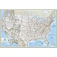
National Geographic United States Maps
National Geographic Maps of the United States of America – Setting the highest standard for cartographic excellence
Since publishing its first map of the United States of America in 1923, National Geographic has been a global leader in the art and science of mapmaking. National Geographic’s unique cartographic style is defined by beautiful color palettes, proprietary typefaces, hand-drawn shaded relief, and carefully researched content. The attention to detail and accuracy is what really sets National Geographic apart from other mapmakers. Each map has been carefully compiled based upon the latest data sources and independent verification of road networks, place-names, and National Park boundaries. When this level of research is combined with great design, the result is the best line of U.S. maps currently available.
Wall Map Formats
- Paper: High-quality matte poster stock, printed in the USA
- Laminated: Plastic gloss lamination increases durability
- Poster size: 24" x 36", designed to fit precut poster frames
- Standard size: Approximately 30" x 46"
- Enlarged size: Approximately 48" x 73
- Mural size: Approximately 77" x 110", comes as three panels that mount using wallpaper glue
Four distinctive styles
|
|
|
|
|
|---|---|---|---|
ClassicThe Classic style is the traditional National Geographic design that has been featured in many of the maps produced as supplements in the National Geographic Magazine over the years. Highlights include blue oceans with bathymetric contour steps, brightly-colored tint bands along country and state borders, and hand-drawn shaded relief. This style contains the highest level of detail. This map is presented in the Lambert Conformal Conic projection, which minimizes distortion in midlatitudes with east-west orientation. |
ExecutiveThe Executive style is a perfect match for home and office décor as it pairs nicely with wood and leather furnishings. Featuring an antique, earth-tone color palette combined with up-to-date cartography, this has become National Geographic’s bestselling U.S. Map design. The subdued beige of the oceans combines nicely with the soft-colored tint bands along country and state borders. This style contains the highest level of detail. This map is presented in the Lambert Conformal Conic projection, which minimizes distortion in midlatitudes with east-west orientation. |
DecoratorThe Decorator style is the brightest of the National Geographic U.S. Map designs and is perfect for kids’ bedrooms, classrooms, and those who want a pop of color on the wall. Featuring solid colors filling each state, pale blue oceans, and a black border around the whole image, this U.S. Map is beautiful and easy-to-read. This style contains the second highest level of detail. This map is presented in the Lambert Conformal Conic projection, which minimizes distortion in midlatitudes with east-west orientation. |
ExplorerThe Explorer style is the most affordable option in the National Geographic U.S. Map product family. It is very similar to the Decorator style, featuring the brightest color palette of the U.S. Map designs. The Explorer is perfect for kids’ bedrooms and classrooms. Featuring solid colors filling each state, pale blue oceans, and a decorative grid-style border around the whole image, this U.S. Map is beautiful and easy-to-read. This style contains the second highest level of detail. This map is presented in the Lambert Conformal Conic projection, which minimizes distortion in midlatitudes with east-west orientation. |


Your Purchase Has Purpose
Every purchase helps support the National Geographic Society, an impact driven, nonprofit organization with global reach that uses the power of science, exploration, education, and storytelling to illuminate and protect the wonder of our world.
About the author
Follow authors to get new release updates, plus improved recommendations.

Reviews with images


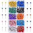
A detailed and accurate map
This map is very nice. I like the paper it's printed on and it's very detailed. I use it with push pins to record the places I have been and it's large enough to read. I would prefer they leave off the white border and enlarge the map itself. Overall I am very happy with it.
Top reviews from the United States
There was a problem filtering reviews right now. Please try again later.

Reviewed in the United States on April 21, 2023


This map is very nice. I like the paper it's printed on and it's very detailed. I use it with push pins to record the places I have been and it's large enough to read. I would prefer they leave off the white border and enlarge the map itself. Overall I am very happy with it.
Images in this review

Reviewed in the United States on June 29, 2013
Top reviews from other countries

Laura Pengelly
Good quality and as expected
Reviewed in the United Kingdom on March 27, 2015