SUMMARY
This is AI generated summarization, which may have errors. For context, always refer to the full article.
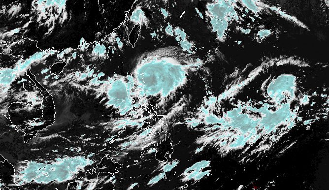
MANILA, Philippines – Typhoon Goring (Saola) steadily intensified on Saturday morning, August 26, while maintaining its generally slow pace off Cagayan.
In a briefing past 11 am on Saturday, the Philippine Atmospheric, Geophysical, and Astronomical Services Administration (PAGASA) said Goring’s maximum sustained winds increased from 140 kilometers per hour to 150 km/h.
The typhoon’s gustiness is now up to 185 km/h from the previous 170 km/h.
Goring is still expected to strengthen into a super typhoon on Monday, August 28 – a regular holiday in the country for National Heroes Day. A super typhoon has maximum sustained winds of 185 km/h or above.
As of 10 am on Saturday, Goring was spotted 155 kilometers east of Aparri, Cagayan, moving south southwest at only 10 km/h.
ALSO ON RAPPLER
- ‘Lot of love’: Towns all respect for Gilas Pilipinas after Dominican Republic win
- Overdue Caloy Loyzaga Hall of Fame honor still ‘means the world,’ says family
- Gibo: Don’t fall for China’s ‘fake news’ on Ayungin
- [Newspoint] The Ninoy constituency
Signal No. 3 has been raised for the first time due to Goring. Below are the areas under tropical cyclone wind signals as of 11 am on Saturday.
Signal No. 3
Storm-force winds (89 to 117 km/h), moderate to significant threat to life and property
- northeastern part of Cagayan (Santa Ana)
- extreme eastern part of Isabela (Divilacan, Palanan)
Signal No. 2
Gale-force winds (62 to 88 km/h), minor to moderate threat to life and property
- eastern part of Isabela (Dinapigue, San Mariano, Ilagan City, Maconacon, Cabagan, Tumauini, San Pablo)
- eastern part of Cagayan (Peñablanca, Baggao, Gattaran, Lal-lo, Gonzaga, Santa Teresita, Buguey)
- northern part of Aurora (Dilasag, Casiguran)
Signal No. 1
Strong winds (39 to 61 km/h), minimal to minor threat to life and property
- Batanes
- rest of Cagayan including Babuyan Islands
- central part of Aurora (Dinalungan, Dipaculao)
- Quirino
- rest of Isabela
- Apayao
- eastern part of Nueva Vizcaya (Kasibu, Quezon, Diadi, Bagabag, Solano, Villaverde)
- eastern part of Ifugao (Lamut, Lagawe, Hingyon, Banaue, Mayoyao, Aguinaldo, Alfonso Lista)
- eastern part of Mountain Province (Barlig, Natonin, Paracelis)
- Kalinga
Meanwhile, PAGASA again updated its rainfall forecast for Goring. The typhoon is bringing moderate to torrential rain, which may cause floods and landslides.
Saturday noon, August 26, to Sunday noon, August 27
- 100-200 millimeters (mm): eastern part of mainland Cagayan, eastern part of Isabela
- 50-100 mm: Babuyan Islands, rest of mainland Cagayan, rest of Isabela, northern part of Aurora, Cordillera Administrative Region, Ilocos Region
Sunday noon, August 27, to Monday noon, August 28
- 100-200 mm: eastern part of mainland Cagayan
- 50-100 mm: Babuyan Islands, rest of mainland Cagayan, eastern part of Isabela, Cordillera Administrative Region, Ilocos Norte, northern part of Aurora
For coastal waters, the gale warning issued at 5 am on Saturday remains in effect. Rough to very rough seas are seen in these seaboards:
- northern and eastern seaboards of Northern Luzon (Batanes, Cagayan including Babuyan Islands, Isabela) – waves 2.8 to 5 meters high
- eastern seaboard of Central Luzon (Aurora) – waves 2.8 to 4.5 meters high
PAGASA advised fishing boats and other small vessels not to sail, and larger vessels to watch out for big waves.
Goring is projected to move south to southwest from Saturday to Sunday, August 27, then turn east to northeast on Sunday.
Afterwards, it will “exit its looping path” and move northwest on Tuesday, August 29, toward the sea east of Taiwan, according to PAGASA.
Taiwan is within the Philippine Area of Responsibility (PAR).
By late Monday or early Tuesday, “upwelling of cooler waters due to its slow movement will limit further intensification,” added the weather bureau.

Goring is also enhancing the southwest monsoon or habagat. Rain from the enhanced southwest monsoon is heaviest in the following areas:
Saturday, August 26
- 50-100 mm: Zambales, Bataan, Occidental Mindoro
Sunday, August 27
- 100-200 mm: Occidental Mindoro
- 50-100 mm: Zambales, Bataan, Cavite, Batangas, northern part of Palawan including Calamian and Cuyo islands, Antique
Monday, August 28
- 100-200 mm: Occidental Mindoro
- 50-100 mm: Zambales, Bataan, Cavite, Batangas, Romblon, northern part of Palawan including Calamian and Cuyo islands, Antique, Guimaras, northwestern part of Aklan
The enhanced southwest monsoon will also trigger gusty conditions in these areas:
Saturday, August 26
- Bataan, Metro Manila, Calabarzon, Bicol, most of Mimaropa
Sunday, August 27
- Bataan, Metro Manila, Calabarzon, Mimaropa, Bicol, Visayas, Dinagat Islands, Camiguin
Monday, August 28
- Bataan, Metro Manila, Calabarzon, Mimaropa, Bicol, Visayas, Dinagat Islands, Camiguin, most of Zamboanga Peninsula
Goring is the Philippines’ seventh tropical cyclone for 2023 and the first for August.
PAGASA previously said it expects two or three tropical cyclones to develop within or enter PAR in August.
A low pressure area (LPA) also remains outside PAR, located 2,150 kilometers east of Central Luzon on Saturday morning.
The LPA has no impact on the country, but it continues to be monitored. – Rappler.com
Add a comment
How does this make you feel?


There are no comments yet. Add your comment to start the conversation.