Urban wildlife corridors: Building bridges for wildlife and people
 Amanda J. Zellmer
 Barbara S. Goto
- 1Department of Biology, Occidental College, Los Angeles, CA, United States
- 2Arroyos & Foothills Conservancy, Pasadena, CA, United States
Urbanization is rapidly expanding across the globe, leading to increasing threats to wildlife in and around cities. Wildlife corridors are one strategy used to connect fragmented wildlife populations; however, building wildlife corridors in urban areas remains a challenge because of the number of barriers between habitat patches and the extensive number of property owners and stakeholders involved. Successful urban wildlife corridor conservation thus requires a collaborative approach and a cohesive plan that transcends municipal boundaries. Here we demonstrate how urban wildlife corridor conservation can provide a unique opportunity to build bridges not only for wildlife but also among scientists, non-profits, government agencies, and communities. Our case study centers on the conservation of a network of wildlife corridors in one of the world's megacities, Los Angeles, and the positive feedback loop sparked by collaboration between research and non-profit work. We discuss the benefits of and challenges to building complex collaborations for the purpose of strengthening urban resilience and redesigning sustainable cities.
Introduction
With the continued growth in cities worldwide, urban ecosystems are rapidly expanding (Grimm et al., 2008). More than 55% of the world's population already live in urban areas and this is expected to grow to over 68% by 2050 (World Urbanization Prospects: The 2018 Revision, 2018). This continued growth increasingly threatens wildlife living in and around cities, such as through isolation in urban green spaces due to habitat fragmentation, increased mortality as a result of vehicle-wildlife collisions, increased exposure to toxins and poisons, exposure to diseases, and competition with introduced species (Kowarik, 2011). Managing urban wildlife populations is not only important for the conservation of these species, but also for the people living in cities. Urban expansion increases the risk for more human-wildlife conflicts (Woodroffe et al., 2005; Skogen et al., 2008), necessitating mitigation to prevent conflict. At the same time, urbanization also reduces opportunities for positive human-wildlife interactions as species become extirpated from isolated habitat patches. This is a concern for city inhabitants because positive human-wildlife interactions can have numerous psychological benefits (Curtin, 2009). Moreover, people living in biologically impoverished areas are subject to increasing “extinction of experience” with nature (Miller, 2005), which in turn may impact their engagement with conservation action (Morrison, 2015, 2016). As such, the loss of wildlife from cities may lead to a breakdown in the virtuous cycle, the positive feedback loop where the societal benefits of biodiversity conservation catalyze increased conservation action (Morrison, 2015, 2016). Because access to nature remains deeply inequitable across cities (Williams et al., 2020), these losses of urban wildlife will disproportionately impact low-income communities and communities of color. Thus, it is essential that we develop successful strategies for urban wildlife conservation that strengthen the virtuous cycle between biodiversity conservation and the people inhabiting cities, both for the sake of wildlife and humans.
Wildlife corridors are frequently used in conservation as a tool to connect wildlife populations that have become isolated because of human-mediated habitat fragmentation (Bennett, 1999). Despite early debate (Beier and Noss, 1998; Haddad et al., 2000), success of wildlife corridors has been documented for several species, with increased movement between isolated populations, increased genetic admixture (Gilbert-Norton et al., 2010; Resasco, 2019), and, when used in conjunction with other mitigation measures, reduced human-wildlife conflicts such as vehicle-wildlife collisions (Rytwinski et al., 2016). Moreover, corridors will be increasingly essential for wildlife to be able to respond to changing climates (Rudnick et al., 2012; Costanza and Terando, 2019; Littlefield et al., 2019; Jennings et al., 2020; Schloss et al., 2022).
Although there is some evidence of the success of wildlife corridors in urban areas (Shwartz et al., 2014; Adams et al., 2017), within cities it is rarely possible to connect habitat patches with a single bridge. Habitat fragments are frequently separated by multiple roads, multiple land parcels with different owners, and may even be separated across different jurisdictions. Furthermore, land ownership and usage within urban areas can change rapidly and unexpectedly. As a result, approaches to wildlife corridor design that are recommended in more rural locations may not be appropriate or successful in urban areas. For instance, recommendations for corridor design include maximizing width of the corridor and exclusion of human development and activity from the corridor (Bond, 2003). Yet, in urban areas, such recommendations are often impossible to achieve. Thus, traditional wildlife corridors, such as a bridge between two conservation landscapes (Beier and Loe, 1992), may not be adequate for protecting connectivity in cities.
These challenges are further compounded by more general difficulties of conservation within urban areas (Shwartz et al., 2014), which continue to limit the success of redesigning cities to be more wildlife-inclusive (Kay et al., 2022). First, in a landscape so heavily dominated by humans, it can be especially challenging to balance the, sometimes, competing needs of people and wildlife (Goswami and Vasudev, 2017; Turo and Gardiner, 2020). Second, biodiversity conservation already requires successful collaboration between multiple stakeholders (Gavin et al., 2018), but this challenge is only intensified in urban settings where, due to smaller parcel sizes, there are far more stakeholders. Third, disciplinary silos between researchers, conservation practitioners, land planners, and policymakers create additional barriers for urban conservation (Kay et al., 2022). Finally, as urban sprawl expands and begins to connect disjunct cities, reducing the remaining open spaces between jurisdictional boundaries (Kraas, 2008), enacting a cohesive conservation plan becomes even more arduous. Conservation within urban areas thus requires a unifying framework to bridge efforts across jurisdictions and stakeholders.
Establishing priority areas for urban wildlife corridors, where efforts are coordinated to preserve multiple pathways and stepping-stones of connectivity, may be one way to facilitate conservation in urban areas. Utilizing a combination of approaches, including green infrastructure, backyard habitat restoration, land acquisitions, and conservation partnerships, urban wildlife corridor conservation has the potential to enhance wildlife connectivity while simultaneously building bridges between the vast network of stakeholders in cities (Figure 1). Although the need for connectivity has long been a primary recommendation for urban conservation (Soulé, 1991), there are few case studies where the process of urban corridor conservation has been fully documented, especially when considering connectivity across multiple land parcels and jurisdictions.
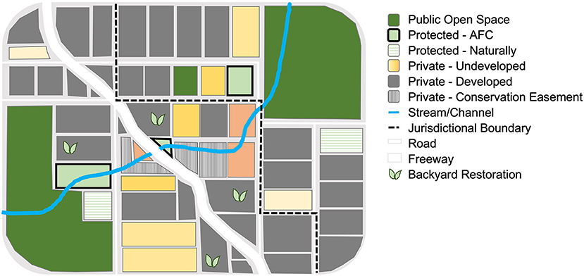
Figure 1. Illustration of the complexity of conserving urban wildlife corridors. Land parcels are shown on a street map with roads (white lines), jurisdictional boundaries (black dashed lines) and an urban stream channel (blue line). The culvert under the freeway (thick white line) would be assessed as a potential wildlife passage corridor. Land parcels are colored based on their ownership and status. Preserved public open space includes parks and undeveloped natural habitat (green). Privately owned undeveloped parcels are split into parcels that have been acquired and therefore protected (light green, black border), parcels that have been protected naturally due to land ordinances (green horizontal stripes), and parcels that have been ranked for corridor conservation need ranging from high (orange) to low (light yellow). Parcels in orange would be ground-truthed to assess conservation potential. Privately owned occupied parcels include developed parcels (grey) and parcels with conservation easements (grey vertical stripes). Properties on which landowners have participated in backyard restoration projects are also indicated (green leaf).
Here, we present a case study of urban wildlife corridor conservation along the eastern edge of the Rim of the Valley Corridor, a series of mountains and open space encircling part of the Metropolitan Los Angeles Area (Figure 2; NPS, 2015), as a framework for addressing the challenges of biodiversity conservation in urban areas. We first defined an urban wildlife corridor priority area to create a database for researching and monitoring connectivity. To track wildlife presence within the priority area, we established a transect of remote-triggered camera traps and collated community science observations of all terrestrial mammal species. We then compared all vacant privately owned land parcels to prioritize conservation needs and make evidence-based decisions for land acquisitions. To encourage backyard restoration on developed land parcels, we initiated a native plant distribution project with local volunteers. Finally, with our database, we established an extensive outreach and education program to build community across stakeholders within and adjacent to the corridor. We use our results to discuss the potential for conserving wildlife corridors in urban areas and highlight remaining challenges.
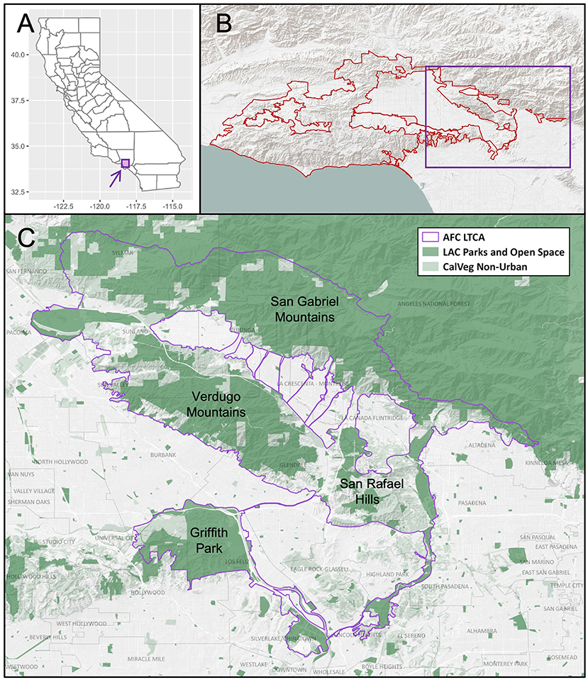
Figure 2. Map of the Arroyos & Foothills Conservancy's Long Term Conservation Area (AFC LTCA) on the eastern edge of the Rim of the Valley Corridor, a case study of an urban wildlife corridor. (A) Location of the study area (purple box) within California. (B) Location of the study area (purple box) in reference to the Rim of the Valley Corridor (red outline). (C) Extent of the LTCA in the Greater Los Angeles area (purple outline). Existing public parks and open space (LA County) are shown in dark green. Remaining land is classified into urban (white) and non-urban (light green; CalVeg). Key areas of protected open space needing connection include the Verdugo Mountains, San Gabriel Mountains, the San Rafael Hills, and Griffith Park.
Methods
Study area
The Greater Los Angeles Area provides an ideal opportunity to highlight the need for and strengths of an urban wildlife corridor framework. Los Angeles is located within the California Floristic Province, an area that is recognized as one of the world's biodiversity hotspots (Cincotta et al., 2000; Myers et al., 2000). Moreover, the topographical complexity of the Greater Los Angeles Area creates numerous physical environments, which gives rise to an impressive amount of biological diversity, with many endemic and endangered species (Dobson et al., 1997).
At the same time, the region has experienced rapid urbanization as a result of population growth and economic expansion (Syphard et al., 2005) and as of 2020 was home to over 18.7 million people (www.census.gov). The layout of the Greater Los Angeles Area exhibits a unique example of the impacts of urban sprawl, encompassing at least 177 communities (Scott, 1995) connected by a vast network of major highways (Fraser et al., 2019). The urban sprawl extends these densely populated areas right up to large undeveloped natural areas, including the Angeles National Forest.
The impacts of urban habitat fragmentation on wildlife populations within Los Angeles has been extensively documented (Riley et al., 2006; Delaney et al., 2010; Ernest et al., 2014; Poessel et al., 2014; Benson et al., 2016; Fraser et al., 2019). Notably, Los Angeles is one of only two megacities in the world that is home to large predatory cats, with the well-known P-22 mountain lion (Puma concolor) living in Griffith Park and other GPS collar tracked mountain lions in fragmented habitat patches nearby (Riley et al., 2014b, 2021). Despite the resilience of these large cats, there remains an urgent need for re-establishment of connectivity (Benson et al., 2016). Recent studies have documented that mountain lions within these habitat patches show evidence of inbreeding (Huffmeyer et al., 2022) and experience mortality risks associated with humans (Benson et al., 2020). Mountain lions provide just one example of the many species that would benefit by improving connectivity among fragmented habitat areas within the Los Angeles metropolis.
Landscape connectivity across California (Spencer et al., 2010) and in Southern California (Beier et al., 2006) has long been a priority for conservation. Notably, however, many efforts to establish priority areas for region-wide connectivity initially excluded highly urbanized areas. More recently, there has been increased effort at setting priorities for conservation of connectivity within the Greater Los Angeles Area. In 2008, the National Park Service, as directed by Congress through the Consolidated Natural Resources Act of 2008 (P.L. 110-229-May 2008), began a study to assess the significance of the Rim of the Valley Corridor, which generally includes the mountains and foothills encircling the San Fernando, La Crescenta, Santa Clarita, Simi, and Conejo Valleys in California (NPS, 2015).
The eastern edge of the Rim of the Valley Corridor is of particular interest because it weaves through Los Angeles. Here, large blocks of natural land, including the Verdugo Mountains, are entirely surrounded by development (Figure 2), yet still are home to wide ranging species, such as mountain lions (Riley et al., 2021). This region is also important for migrating birds (Terrill et al., 2021) and other species that require migration or dispersal corridors, such as monarch butterflies (Danaus plexippus). The Arroyos & Foothills Conservancy (AFC) - a land trust dedicated to conservation, restoration, and education - began to lead a collaborative effort to study, monitor, and acquire properties within this region in 2012 in an effort to preserve and restore connectivity. In 2017, AFC formed a partnership with Occidental College to begin a research program studying connectivity throughout the region, primarily for medium to large terrestrial mammals. Through this collaboration, we combine research, land acquisition, restoration and stewardship, and outreach and education in order to conserve wildlife corridors within an urban area (Figure 3).

Figure 3. Graphical abstract of urban wildlife corridor conservation strategy. Urban wildlife corridor conservation requires a multi-pronged, collaborative approach including research, land acquisitions, restoration and stewardship, and outreach and education. CWPAs refers to critical wildlife passage areas.
Urban wildlife corridor assessment
We began by designating a priority area for urban wildlife corridor conservation, which we call the Long-Term Conservation Area (LTCA). The LTCA was initially established within a buffer around each of the undeveloped, publicly owned protected habitat patches in the eastern edge of the Rim of the Valley Corridor and the narrowest connections between these protected spaces. The LTCA was revised periodically to incorporate new data, including expanding the extent of the focal area to reach additional protected spaces as well as adding additional routes of connectivity as new data came available.
Within the LTCA, we investigated the potential for wildlife passage between preserved open spaces using a combination of GIS data, wildlife observations, and scouting potential routes of wildlife movement. To begin, we used the CalVeg layer (USDA, 2004) and Google Earth to identify the most continuous and direct routes for wildlife movement between preserved open spaces. Specifically, we created a polygon shapefile of Critical Wildlife Passage Areas (CWPAs) outlining all areas where undeveloped habitat appeared, based on our remotely sensed data, to be physically connected to preserved open spaces, or where there was potential for connectivity (provided some remediation was completed). Once these areas were visually identified from the maps, we began the process of ground-truthing by collating wildlife observations (described below), walking the potential routes, evaluating habitat quality (e.g., availability of habitat, availability of water sources, low noise and light pollution), and identifying both conduits (e.g., underpasses, culverts, channels) and barriers (e.g., fencing, roads, structures) to wildlife movement. With these data, we then refined the CWPAs shapefile to focus on regions that were deemed most suitable to wildlife movement. In addition, we created a polyline shapefile of potential routes for wildlife movement through the CWPAs. The CWPAs and potential routes were continually re-evaluated as new information was gained or as conditions changed.
To assess wildlife presence within and adjacent to the LTCA, we monitored terrestrial mammals using remote-triggered camera traps and community science data. We established a transect through the LTCA where we deployed cameras beginning in October 2018. The cameras were set up in month-long sampling periods four times per year through January 2022 following the Urban Wildlife Information Network (UWIN) protocol (Magle et al., 2019) and opportunistically at other times of the year. Cameras were also deployed opportunistically when invited by community partners or at the discretion of landowners. The make and model of the cameras included Browning Dark Ops Elite HD, Browning Strikeforce HD, and Reconyx Hyperfire. Photos were uploaded to the UWIN Database and classified by at least two people, including both researchers and trained volunteers (Katrak-Adefowora et al., 2020). Photos with inconsistent classifications between the first two observers were validated by a third person. Beginning in 2021, we pre-filtered out empty images and images with humans using the machine learning photo detection pipeline, Megadetector (Beery et al., 2019), using a detection confidence cutoff of 0.8.
In addition, we compiled community science observations of terrestrial mammals within and adjacent to the priority conservation area by establishing a project on the iNaturalist database (www.inaturalist.org/projects/la-wildlife-connectivity). We downloaded all observations with a spatial locality accuracy of 1 km or less between January 2012 and August 2022. We included only research grade observations. In addition, we began monitoring social media sites including Facebook groups, Ring Neighbors, and Nextdoor in 2019 and recorded all wildlife observation posts with spatial locality information. We quantified the total number of observations of each terrestrial mammal species recorded within the LTCA and within CWPAs.
Parcel evaluation
After establishing the perimeter of the LTCA, we collated data on all land parcels within the perimeter. We downloaded parcel information for all properties within the LTCA from the Los Angeles County assessor's office and created a parcel database. Parcel information included parcel boundaries, landowner information, and information about publicly owned parcels.
We then compiled spatially-explicit data on key features relating to the suitability of habitat for wildlife movement (Duttweiler, 2021 unpublished), including functional landscape connectivity, presence of rare or sensitive plant or animal species, presence of rare or sensitive terrestrial communities, presence of critical or wetland habitat, presence of rivers or streams, presence of desirable vegetation, coincident with areas prioritized by others, coincident with CWPAs, and proximity to roadway bridges, drainages, and other protected area.
To assess conservation needs and prioritize land acquisitions, we developed a Parcel Evaluation Tool (PET) (Duttweiler, 2021 unpublished), which allowed us to compare land on a parcel-by-parcel basis. We used the PET to evaluate all privately owned, vacant land parcels as well as some privately owned developed parcels with sufficient habitat in a CWPA where conservation easements may contribute to conservation of connectivity. Parcels were ranked based on weighted scores for the factors described above. Land parcels were then ranked into four quartiles. Highly ranked properties identified by the PET along with opportunistic properties were ground-truthed to validate our rankings and assess conservation potential. To accomplish this, we gathered more fine-scale habitat and wildlife data and solicited expert review from wildlife biologists, land development experts, and urban planners. In addition, we reached out to individual landowners, gathered wildlife observation data using remote-triggered camera traps, talked to neighbors, and walked the communities where these parcels are located. Parcels were then classified with a conservation status: Protected, Protected Naturally, Protected by Others, Monitor, Revisit, Passed, Under Contract, Target—Owner Contacted, Target—Owner Not Contacted. Once a property was identified as a target for pursuit, we began the process of land acquisition, negotiating conservation easements, or supporting others in acquiring the property for conservation. As properties were acquired and new information became available, we reassessed parcel prioritization to monitor changes in conservation needs across the LTCA.
Restoration and stewardship
For acquired properties, we began habitat restoration and monitoring of wildlife with remote-triggered camera traps. We also recruited neighborhood volunteers to help monitor and manage each property. We then developed an adaptive management plan for each property including restoration as well as fire fuel reduction and any other projects identified by our Friends groups and stewardship advisors as beneficial to the overall biodiversity of the property.
In addition to acquiring and conserving properties, we facilitated backyard restoration within and adjacent to the LTCA. One example of this is the Monarch Recovery Program. We distributed native milkweed plants (Asclepias fascicularis and A. eriocarpa) to volunteers, who then planted their milkweed plants in their backyards or neighborhoods. Volunteers were then instructed to upload the coordinates of their milkweed plants into an online ArcGIS database. We mapped the distribution of the planted milkweed to evaluate the spatial extent of the plantings. After 6 months, volunteers were asked to report the status of their milkweed plants.
Collaboration, outreach and education
To enable conservation across the LTCA, we shared our data with stakeholders. Data were shared through various approaches including meetings with stakeholders, public comments on policy recommendations, presenting at conferences, and publishing in scientific journals. We provided data by request, including connectivity assessments and species observations.
In addition, we developed an outreach and education program to disseminate the results of our research and to empower residents within and adjacent to the urban wildlife LTCA to contribute to conservation. We hosted field trips with local schools and organizations on AFC owned properties within the corridor. We hosted volunteer events to enable restoration on acquired properties. Wildlife Movement curriculum was developed to teach students about the importance of the corridor for wildlife movement and made available to teachers. We attended community events and contributed to exhibits to share the results of our research with the broader community. We established an internship program for high school and college students for hands-on training in urban wildlife corridor conservation and research. Finally, we trained volunteers to assist in urban wildlife corridor conservation. We held frequent meetings to bring researchers, conservation practitioners, volunteers, and interns together to discuss research, learn new approaches to conservation, and collaboratively set goals for conservation and research within the corridor.
Results
Urban wildlife corridor assessment
Within our study area, we identified a total of 2.43 × 10⁵ km2 of land as a priority area for urban wildlife corridor conservation (LTCA; Figure 2). The LTCA traversed 22 jurisdictions within Los Angeles County. To date, we have identified 17 CWPAs within the LTCA and 156 potential routes for wildlife movement.
Camera trap and community science observations confirmed numerous wildlife species are present within this key urban wildlife corridor. Between September 2018 and February 2022, we documented 25,333 photos with positive wildlife detections of at least 63 wildlife species on our camera traps across 43 unique sites within the LTCA. This includes at least 19 terrestrial mammal species (Table 1), as well as many bird, amphibian, and reptile species. The community science dataset included an additional 8,360 mammal observations. Of those observations, 3,933 were within the LTCA and 1,644 were within CWPAs, representing 31 species (Table 2).
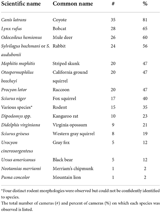
Table 1. Number and percentage of sites at which each terrestrial mammal species was observed along a transect of remote-sensored wildlife cameras between September 2018 and February 2022.
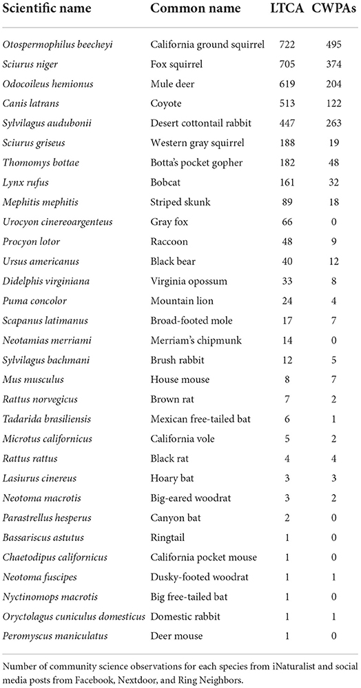
Table 2. Terrestrial mammal species observed by community scientists within AFC's Long Term Conservation Area (LTCA) and within the Critical Wildlife Passage Areas (CWPAs).
Parcel evaluation
Within the LTCA, we identified a total of 28,994 unique land parcels. We evaluated 5,461 of these parcels with the PET, with 2,013 parcels within or overlapping CWPAs. To date, we have reviewed a total of 734 parcels for conservation potential. Of these parcels, we assigned 728 a conservation status. AFC acquired and preserved 29 parcels, supported the acquisition of 23 others, and is currently under contract to acquire 14 more. Additionally, we deemed nine properties as Protected Naturally due to land ordinances or access issues, although this status is continually re-evaluated.
Restoration
As of July 2022, a total of 371 volunteers signed up to adopt milkweed plants. Of those volunteers, 209 adopted milkweed plants with the remaining on a waitlist. A total of 172 volunteers reported their results in the online portal representing 172 unique locations where milkweed was planted. The planted milkweed covered the full extent of our LTCA and extended outside the LTCA as well (Figure 4). Of the 172 initial respondents, 83 responded to our second survey to report the status of their milkweed plants after approximately 6–7 months.
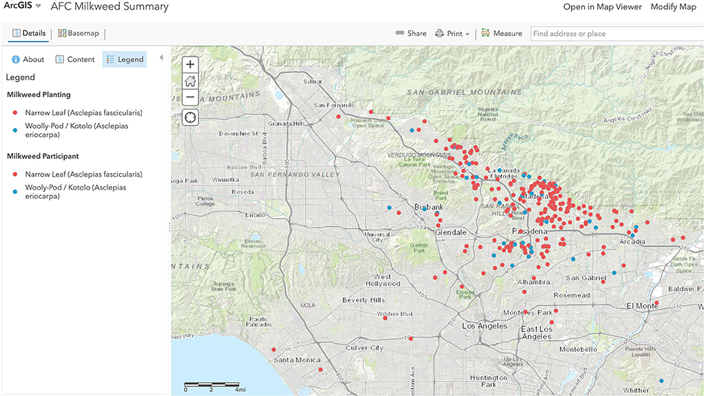
Figure 4. Screenshot of interactive map illustrating community participation in supporting an urban wildlife corridor through planting native milkweed to support monarch butterflies. The map shows the locations and status of two native milkweed plant species distributed to volunteers and planted in backyards and neighborhoods in and adjacent to the LTCA.
Collaboration, outreach and education
We invited a total of 40 different types of stakeholders to participate in urban wildlife corridor conservation through stakeholder meetings or outreach and education events (Table 3).
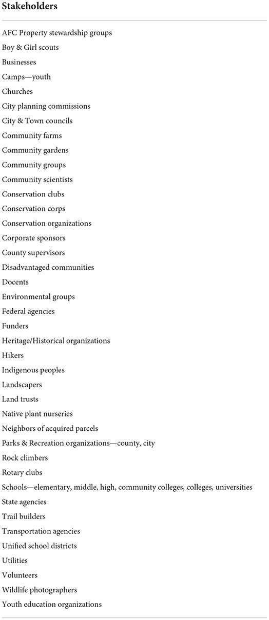
Table 3. List of stakeholders invited to participate in urban wildlife corridor conservation.
Discussion
Wildlife corridors are increasingly being used to connect fragmented populations but how this is accomplished in urban areas, where conservation of connectivity requires coordination across multiple barriers and land parcels as well as the collaboration of numerous stakeholders, remains a challenge. We set out to use an evidence-based framework for conserving urban wildlife corridors in the Greater Los Angeles Area. We found that the eastern edge of the Rim of the Valley Corridor alone includes over 28,000 land parcels and extends through a total of 22 jurisdictions. These results demonstrate the extraordinary number of properties and landowners as well as the extensive research and data needed to coordinate conservation of wildlife corridors within an urban area. As such, the results highlight the need for a cohesive framework for conservation. By establishing a priority area for conservation of landscape connectivity (LTCA) and building a database of all land parcels within that area, we were able to build a structure for gathering data, prioritizing conservation needs, and integrating research, conservation, and policy. With our framework in place and these data in hand, we were able to efficiently contribute to conservation of habitat for wildlife movement within one of the world's megacities.
Central to our approach to urban wildlife corridor conservation is the preservation and restoration of remaining undeveloped land through acquisitions and conservation easements to prevent further loss of connectivity. Notably, we identified over 5,460 privately owned vacant lots within the priority corridor area. While these lots vary in the quality and potential for supporting wildlife movement, future development of some of these properties would weaken connectivity throughout the region. By comparing land parcels based on their potential to contribute to wildlife connectivity, we were able to monitor and identify priority parcels for conservation. To date, we have acquired or assisted in the acquisition of 52 parcels. These parcels constitute a total of 1.19 km2 of land, with 19 parcels within or overlapping CWPAs. Some of the parcels that were conserved fall within narrow strips of remaining habitat that connect two protected open spaces and had these parcels not been conserved, connectivity would have been severed. However, additional acquisitions and easements will be needed to guarantee preservation of structural connectivity throughout the region for the long term.
In addition to land acquisitions, we identified numerous potential routes along which connectivity will need to be restored, particularly across roads and fenced areas. A number of solutions have been suggested for mitigating the impacts of roads on wildlife connectivity, with wildlife bridges being a primary example (Riley et al., 2014a). However, as the construction of wildlife bridges remains an expensive option, lower cost options will be necessary to restore connectivity across the many different roads bisecting cities. One opportunity for restoring connectivity is through remediation of channelized stream beds, which have the potential to provide physical connections between protected open spaces, undercutting barriers such as roads and bypassing urban development. Previous research has shown that some species in Southern California will utilize culverts and undercrossings depending on the design of the undercrossing as well as the availability of habitat (Ng et al., 2004); however, there is little research on the extent to which wildlife will then continue on to use channelized stream beds for moving between habitat patches. Although we documented the presence of multiple species within and along urban channels using camera traps and community science observations, further research is needed to fully evaluate the extent to which channels are utilized for wildlife movement and which channel designs best improve functional connectivity. Habitat restoration, fence removal, and setbacks could make urban channels more conducive to wildlife movement. However, additional mitigation strategies will be needed in areas where there are no suitable underpasses or culverts.
Simply building structural connectivity between habitat patches will not be enough to guarantee functional connectivity for wildlife (Baguette and Van Dyck, 2007), and this may be especially a concern in cities where corridors may have degraded habitat or the presence of humans may reduce permeability to wildlife movement. Evaluation of the effectiveness of wildlife corridors is essential for providing feedback to policymakers and practitioners as to whether these corridors are functioning as intended (Caro et al., 2009; Cushman et al., 2013; Brodie et al., 2016; Bond et al., 2017). Our results demonstrate that numerous wildlife species continue to persist throughout our proposed corridor region (Tables 1, 2). More importantly, our research suggests that wildlife, and even mountain lions and other species that typically avoid urban areas, are present within our defined CWPAs (Table 2). These results bolster previous research on wildlife movement within Los Angeles (Ng et al., 2004; Riley et al., 2021), providing additional evidence for the need to conserve connectivity in this region. Yet, for many species and across many parts of the world, urban biodiversity remains understudied (Magle et al., 2012; Collins et al., 2021). A dedicated focus on modeling and assessing how wildlife use urban wildlife corridors would help fill important gaps in urban biodiversity research while also providing expertise needed for conservation planning.
In addition to creating corridors for wildlife, building a framework for monitoring and protecting habitat for wildlife corridors in an urban area provides an opportunity to build bridges between all the stakeholders involved in urban conservation. First, our analysis allowed us to build a database of all landowners within and adjacent to the LTCA. With this database, we were able to reach out to landowners and host neighborhood events to bring stakeholders together and foster community around a common goal. These conversations allowed us to hear the needs and concerns of local landowners and residents and share data about wildlife movement. Creation of volunteer-driven community stewardship groups centered around protected wildlife corridors created a connection between the land being conserved and the neighbors who live there. In addition, it helped foster crucial relationships among landowners. For instance, volunteers in our Monarch Recovery Program were not only able to meet each other at milkweed distribution events but more importantly were able to visualize their connection to others and to the overall corridor through our online portal (Figure 4) while at the same time contributing to research on the success of the corridor. By prioritizing these relationships among stakeholders, we were better able to build trust, a key factor in success of conservation programs (Young et al., 2013).
Second, our urban wildlife corridor framework helped us connect research and data with conservation and policy. Specifically, to enable an evidence-based approach to urban wildlife corridor conservation, we established a collaboration between researchers at an academic institution (Occidental College) with conservation practitioners at a non-profit land trust (AFC). Through this collaboration, we were able to jointly determine research needs within the wildlife corridor, negotiate permissions for land access for wildlife research, and provide recommendations for land acquisitions based on data collected within the LTCA. This collaboration was a stepping-stone to more broadly sharing data across researchers, conservation practitioners, and policymakers across the LTCA. Open access data can serve as a tool to help bridge the gap between science and action, by providing conservation practitioners and policymakers with access to relevant data in near real time (Sullivan et al., 2014). As such, we provide wildlife observation data and landscape connectivity models by request to municipalities, state agencies, and other conservation partners. We also provide municipalities with focused prioritization data for open space parcels within their jurisdiction. Through these collaborations, we were able to overcome disciplinary silos, a key barrier to urban conservation (Kay et al., 2022).
Moreover, designating a priority area for urban wildlife corridor conservation forced us to think across jurisdictional boundaries. Our analysis identified 22 jurisdictions within our priority wildlife corridor area. Wildlife do not necessarily recognize human political boundaries as they move across the landscape (Peters et al., 2018) and as a result may experience inconsistent protection of their corridors (Titley et al., 2021). Across these 22 jurisdictions, we identified variation in habitat protections. For instance, within our proposed corridor one key ordinance that is relevant to conservation of wildlife corridors is the regulation of hillside development. Properties in steep hillsides may be prohibited from development, resulting in conservation by default. However, each jurisdiction defined the hillside areas subject to these regulations differently. The cities of Burbank and Los Angeles use a map to zone hillsides while the County of Los Angeles defines a “Hillside Management Area” as land with a natural slope gradient of 25% or steeper. Some jurisdictions impose additional restrictions designed to protect ridgelines and views, along with protections for specific plant species such as oak trees. As a result, protections may be lost as the corridor passes between neighboring jurisdictions, making a comprehensive assessment essential. By having an urban wildlife corridor framework that assembles and analyzes habitat protections across all jurisdictions simultaneously, we were able to create and execute on an action plan more knowledgably and effectively.
Remaining challenges and recommendations
While an urban wildlife corridor framework can enable conservation within cities, there remain challenges that need to be addressed. Primarily, there is a need for leadership in not only proposing urban wildlife corridors but also in providing and funding the structures necessary for collaboration. At the same time, this leadership needs to be collaboratively driven to maintain equity and prevent unintended power dynamics, such as negative interdependence (Trif et al., 2022), in managing conservation across the corridor. Establishing a collaborative network to lead this effort could serve as a platform for data sharing, peer networking, and more consistent land stewardship across multiple jurisdictions. The nascent collaboration created through our study highlights one path that can be used to achieve meaningful connections for empowering multiple stakeholders in an urban wildlife corridor, but further collaboration and leadership are needed to fully realize the benefits for conservation.
While utilizing an urban wildlife corridor framework has enabled conservation within the Rim of the Valley Corridor, how this approach will apply to other cities and other urban ecosystems remains to be tested. Substantial variation exists across cities in terms of size, density of human populations, the distribution of greenspace or natural areas, as well as the species present, and these differences can have a significant effect on the presence of wildlife (Fidino et al., 2020). In addition, policies and land practices across cities may impact the ability to establish successful wildlife corridors within different urban areas. Our approach relies heavily on conserving land that is undeveloped in order to preserve remaining habitat connectivity; however, in many urban areas, undeveloped vacant parcels may be scarce. Alternative approaches such as land ordinances, incentives, and conservation easements may prove more fruitful in such urban areas.
Additionally, human-wildlife conflicts pose a particularly difficult problem for urban conservation (Dickman, 2010), and wildlife movement through corridors can increase conflicts in some cases (Buchholtz et al., 2020). Human-wildlife conflicts, such as pet depredation by wildlife, occurs more frequently in areas with dense human populations (Poessel et al., 2017). As a result, some people may have negative perceptions of wildlife or even fear some species, which may create stakeholder disagreement. As such, extensive consideration must be placed into the shape and design of urban wildlife corridors to prevent unwanted consequences. For instance, mitigation structures designed to route wildlife to safer road crossings have been shown to significantly reduce wildlife-vehicle collisions (Rytwinski et al., 2016). Additionally, outreach and education may help to alleviate fears and address misconceptions. For example, increasing connectivity may instead reduce the risk of human-wildlife conflict because wildlife are able to move more freely to access resources, thereby reducing their need to forage or hunt within backyards and neighborhoods. Shifting attitudes about wildlife from conflict to coexistence (Dickman, 2010; Buijs and Jacobs, 2021) will be essential for successful conservation of urban wildlife corridors. More research will be needed on the best approaches for reducing human-wildlife conflict in urban areas.
Similarly, there remains a challenge in building wildlife corridors within urban areas where there are competing needs between wildlife and humans. Building urban wildlife corridors increases greenspace within cities, which has numerous benefits for the human inhabitants within cities. Access to greenspace supports recovery from stress, child development, and other physical health and psychological benefits (Kowarik, 2011; Scott et al., 2018), and greenspace can mitigate impacts of climate change and urban heat islands (Park et al., 2017). However, wildlife may be less likely to use corridors if there is too much human activity within these spaces (Bond, 2003). As such, a careful balance needs to be struck. There remains a lack of research on the ability of infrastructure and management to alleviate the impacts of human activity on wildlife (Sweeny and LaClair, 2000). Thus, future research is needed to determine how best to design urban corridors to allow for human access to these spaces while simultaneously minimizing the impact of human activity on wildlife movement.
Furthermore, it is important to consider issues of environmental justice when establishing urban wildlife corridors. Access to greenspace and nature within cities is not equitably distributed, with low-income communities on average being located farther from parks and natural spaces within the city (Williams et al., 2020). In fact, in many areas, city inhabitants are located more than a 20-min walk from the nearest park (Williams et al., 2020). These inequities are also linked to systemic racism and historic practices such as redlining, which have continued consequences for the distribution of biodiversity and wildlife within cities (Schell et al., 2020; Vasquez and Wood, 2022). Urban wildlife corridors have the potential to transform equity in access to nature by building habitat connectivity through areas impoverished of nature. Yet because wealth has been associated with biodiversity conservation (Leong et al., 2018), there remains a risk that urban wildlife corridors will be inequitably conserved across cities. As such, care must be taken to assure that wildlife corridors are established in an equitable manner within cities.
At the same time, building of wildlife corridors in areas impoverished of nature may have the unintended consequence of eco-gentrification. While preserving and restoring habitat within an urban area has many benefits for both wildlife and human health, it may also have an unintended impact of displacement of residents as property values rise due to environmental remediation and investment (Wolch et al., 2014; Rice et al., 2020). As a result, care must be taken to consider placement of greenspaces so that they can improve the local environment without displacing low-income communities. Calling attention to and organizing community discussions around the issue of eco-gentrification is the first step in addressing this potential threat to the success of urban wildlife corridors (Mayayo, 2019).
Finally, funding conservation of wildlife corridors in urban areas is particularly challenging. Since urban wildlife corridors require preservation and acquisition of stepping-stones through the urban environment, many small land parcels may need to be restored or purchased. However, these smaller land parcels are also more difficult and expensive to fund. First, it is much easier to describe to funders how hundreds of acres of open space will function ecologically, than to help them visualize how a one-acre parcel is essential in a series of yet-to-be-acquired habitat fragments. Second, the acquisition cost per acre is higher in urban areas than more rural areas (Nolte, 2020). Third, acquisition, restoration, and management of multiple land parcels is more expensive and time consuming than a single large land parcel. Creative approaches to funding conservation within urban areas, such as incentives (Ring et al., 1998) or Conservation Subdivisions (Carter, 2009), will need to be developed.
Summary
Conservation within urban areas is essential for many wildlife species and for improving equity in access to nature, but many challenges exist. Our approach provides one example of how urban wildlife corridor conservation can be achieved through research, land acquisitions, collaboration, restoration and stewardship, and outreach and education. We demonstrate that urban wildlife corridors can provide a framework for conservation in cities that helps to overcome some of the challenges to urban conservation. By explicitly weaving together natural and urban spaces, urban wildlife corridors bridge important gaps between researchers and practitioners, numerous stakeholders, neighboring jurisdictions, complementary datasets, as well as between humans and wildlife. Ultimately, utilizing a collaborative urban wildlife corridor framework for conservation in cities can increase the efficiency of conservation efforts, help redesign cities to be more wildlife-inclusive, and build crucial connections among stakeholders to enable further action.
Data availability statement
The original contributions presented in the study are included in the article/supplementary material, further inquiries can be directed to the corresponding author/s.
Author contributions
All authors contributed to all aspects of the work, from the design and conception of the ideas to the writing and editing the manuscript. All authors contributed to the article and approved the submitted version.
Funding
Funding for camera trap research was provided by Disney Conservation Fund and Occidental College. Additional project funders include the Cygnet Family Foundation, Michael J. Connell Foundation and Southern California Edison. The Monarch Recovery Project was supported in part by the Santa Monica Mountains Conservancy (3810-P68-2142) and Pasadena Community Foundation. Open access publication was funded by Occidental College.
Acknowledgments
We thank the supporters and staff of AFC, the Occidental-AFC camera team, Mark Duttweiler, Roshni Katrak-Adefowora, Maggie Swomley, and Auxenia Privett-Mendoza for their leadership in studying urban wildlife corridors in Los Angeles. We thank the United States Geological Survey for camera trap supplies. We thank the Urban Wildlife Information Network and the Lincoln Park Zoo Urban Wildlife Institute for database support and methodological design review. We thank Scott Harris, Kat Superfisky, and Sophie Parker for insightful discussions that inspired this work.
Conflict of interest
Author BG was employed by Arroyos & Foothills Conservancy.
The remaining author declares that the research was conducted in the absence of any commercial or financial relationships that could be construed as a potential conflict of interest.
Publisher's note
All claims expressed in this article are solely those of the authors and do not necessarily represent those of their affiliated organizations, or those of the publisher, the editors and the reviewers. Any product that may be evaluated in this article, or claim that may be made by its manufacturer, is not guaranteed or endorsed by the publisher.
References
Adams, T. S. F., Chase, M. J., Rogers, T. L., and Leggett, K. E. A. (2017). Taking the elephant out of the room and into the corridor: can urban corridors work? Oryx 51, 347–353. doi: 10.1017/S0030605315001246
Baguette, M., and Van Dyck, H. (2007). Landscape connectivity and animal behavior: functional grain as a key determinant for dispersal. Landsc. Ecol. 22, 1117–1129. doi: 10.1007/s10980-007-9108-4
Beery, S., Morris, D., and Yang, S. (2019). Efficient Pipeline for Camera Trap Image Review. Available online at: http://arxiv.org/abs/1907.06772 (accessed July 1, 2021).
Beier, P., and Loe, S. (1992). In my experience: a checklist for evaluating impacts to wildlife movement corridors. Wildl. Soc. Bull. 20, 434–440.
Beier, P., and Noss, R. F. (1998). Do habitat corridors provide connectivity? Conserv. Biol. 12, 1241–1252. doi: 10.1111/j.1523-1739.1998.98036.x
Beier, P., Penrod, K. L., Luke, C., Spencer, W. D., and Cabañero, C. (2006). “South Coast Missing Linkages: restoring connectivity to wildlands in the largest metropolitan area in the United States,” in Crooks, K., and Sanjayan, M. (eds.). (2006). Connectivity Conservation (Conservation Biology). Cambridge: Cambridge University Press. 555–586. doi: 10.1017/CBO9780511754821
Bennett, A. F. (1999). Linkages in the Landscape: The Role of Corridors and Connectivity in Wildlife Conservation. Gland; Cambridge: IUCN. xiv + 254.
Benson, J. F., Mahoney, P. J., Sikich, J. A., Serieys, L. E. K., Pollinger, J. P., Ernest, H. B., et al. (2016). Interactions between demography, genetics, and landscape connectivity increase extinction probability for a small population of large carnivores in a major metropolitan area. Proc. R. Soc. B Biol. Sci. 283. doi: 10.1098/rspb.2016.0957
Benson, J. F., Sikich, J. A., and Riley, S. P. D. (2020). Survival and competing mortality risks of mountain lions in a major metropolitan area. Biol. Conserv. 241. doi: 10.1016/j.biocon.2019.108294
Bond, M. (2003). Principles of Wildlife Corridor Design. Available online at: https://www.biologicaldiversity.org/publications/papers/wild-corridors.pdf (accessed May 20, 2022).
Bond, M. L., Bradley, C. M., Kiffner, C., Morrison, T. A., and Lee, D. E. (2017). A multi-method approach to delineate and validate migratory corridors. Landsc. Ecol. 32, 1705–1721. doi: 10.1007/s10980-017-0537-4
Brodie, J. F., Paxton, M., Nagulendran, K., Balamurugan, G., Clements, G. R., Reynolds, G., et al. (2016). Connecting science, policy, and implementation for landscape-scale habitat connectivity. Conserv. Biol. 30, 950–961. doi: 10.1111/cobi.12667
Buchholtz, E. K., Stronza, A., Songhurst, A., McCulloch, G., and Fitzgerald, L. A. (2020). Using landscape connectivity to predict human-wildlife conflict. Biol. Conserv. 248, 108677. doi: 10.1016/j.biocon.2020.108677
Buijs, A., and Jacobs, M. (2021). Avoiding negativity bias: towards a positive psychology of human–wildlife relationships. Ambio 50, 281–288. doi: 10.1007/s13280-020-01394-w
Caro, T., Jones, T., and Davenport, T. R. B. (2009). Realities of documenting wildlife corridors in tropical countries. Biol. Conserv. 142, 2807–2811. doi: 10.1016/j.biocon.2009.06.011
Carter, T. (2009). Developing conservation subdivisions: ecological constraints, regulatory barriers, and market incentives. Landsc. Urban Plan. 92, 117–124. doi: 10.1016/j.landurbplan.2009.03.004
Cincotta, R. P., Wisnewski, J., and Engelman, R. (2000). Human population in the biodiversity hotspots. Nature 404, 990–992. doi: 10.1038/35010105
Collins, M. K., Magle, S. B., and Gallo, T. (2021). Global trends in urban wildlife ecology and conservation. Biol. Conserv. 261, 109236. doi: 10.1016/j.biocon.2021.109236
Costanza, J. K., and Terando, A. J. (2019). Landscape connectivity planning for adaptation to future climate and land-use change. Curr. Landsc. Ecol. Rep. 4, 1–13. doi: 10.1007/s40823-019-0035-2
Curtin, S. (2009). Wildlife tourism: The intangible, psychological benefits of human-wildlife encounters. Curr. Issues Tour. 12, 451–474. doi: 10.1080/13683500903042857
Cushman, S. A., Mcrae, B., Adriaensen, F., Beier, P., Shirley, M., and Zeller, K. (2013). Biological corridors and connectivity. Key Top. Conserv. Biol. 2, 384–404. doi: 10.1002/9781118520178.ch21
Delaney, K. S., Riley, S. P. D., and Fisher, R. N. (2010). A rapid, strong, and convergent genetic response to urban habitat fragmentation in four divergent and widespread vertebrates. PLoS ONE 5, 1–11. doi: 10.1371/journal.pone.0012767
Dickman, A. J. (2010). Complexities of conflict: The importance of considering social factors for effectively resolving human-wildlife conflict. Anim. Conserv. 13, 458–466. doi: 10.1111/j.1469-1795.2010.00368.x
Dobson, A. P., Rodriguez, J. P., Roberts, W. M., and Wilcove, D. S. (1997). Geographic distribution of endangered species in the United States. Science (80-.)275, 550–553. doi: 10.1126/science.275.5299.550
Ernest, H. B., Vickers, T. W., Morrison, S. A., Buchalski, M. R., and Boyce, W. M. (2014). Fractured genetic connectivity threatens a Southern California puma (Puma concolor) population. PLoS ONE 9, 7985. doi: 10.1371/journal.pone.0107985
Fidino, M., Gallo, T., Lehrer, E. W., Murray, M. H., Kay, C., Sander, H. A., et al. (2020). Landscape-scale differences among cities alter common species' responses to urbanization. Ecol. Appl. 31, e02253. doi: 10.1002/eap.2253
Fraser, D. L., Ironside, K., Wayne, R. K., and Boydston, E. E. (2019). Connectivity of mule deer (Odocoileus hemionus) populations in a highly fragmented urban landscape. Landsc. Ecol. 34, 1097–1115. doi: 10.1007/s10980-019-00824-9
Gavin, M. C., McCarter, J., Berkes, F., Mead, A. T. P., Sterling, E. J., Tang, R., et al. (2018). Effective biodiversity conservation requires dynamic, pluralistic, partnership-based approaches. Sustainability 10, 1–11. doi: 10.3390/su10061846
Gilbert-Norton, L., Wilson, R., Stevens, J. R., and Beard, K. H. (2010). A meta-analytic review of corridor effectiveness. Conserv. Biol. 24, 660–668. doi: 10.1111/j.1523-1739.2010.01450.x
Goswami, V. R., and Vasudev, D. (2017). Triage of conservation needs: the juxtaposition of conflict mitigation and connectivity considerations in heterogeneous, human-dominated landscapes. Front. Ecol. Evol. 4, 1–7. doi: 10.3389/fevo.2016.00144
Grimm, N. B., Faeth, S. H., Golubiewski, N. E., Redman, C. L., Wu, J., Bai, X., et al. (2008). Global change and the ecology of cities. Science (80-.) 319, 756–760. doi: 10.1126/science.1150195
Haddad, N. M., Rosenberg, D. K., Noon, B. R., Haddad, N. M., Rosenberg, D. K., and Noont, B. R. (2000). On Experimentation and the Study of Corridors : response to Beier and Noss. Conserv. Biol. 14, 1543–1545. doi: 10.1046/j.1523-1739.2000.99572.x
Huffmeyer, A. A., Sikich, J. A., Vickers, T. W., Riley, S. P. D., and Wayne, R. K. (2022). First reproductive signs of inbreeding depression in Southern California male mountain lions (Puma concolor). Theriogenology 177, 157–164. doi: 10.1016/j.theriogenology.2021.10.016
Jennings, M. K., Haeuser, E., Foote, D., Lewison, R. L., and Conlisk, E. (2020). Planning for dynamic connectivity: operationalizing robust decision-making and prioritization across landscapes experiencing climate and land-use change. Land 9, 341. doi: 10.3390/land9100341
Katrak-Adefowora, R., Blickley, J. L., and Zellmer, A. J. (2020). Just-in-time training improves accuracy of citizen scientist wildlife identifications from camera trap photos. Citiz. Sci. Theory Pract. 5, 1–11. doi: 10.5334/cstp.219
Kay, C. A. M., Rohnke, A. T., Sander, H. A., Stankowich, T., Fidino, M., Murray, M. H., et al. (2022). Barriers to building wildlife-inclusive cities: Insights from the deliberations of urban ecologists, urban planners and landscape designers. People Nat. 4, 62–70. doi: 10.1002/pan3.10283
Kowarik, I. (2011). Novel urban ecosystems, biodiversity, and conservation. Environ. Pollut. 159, 1974–1983. doi: 10.1016/j.envpol.2011.02.022
Kraas, F. (2008). “Megacities as global risk areas,” in Urban Ecology. An International Perspective on the Interaction Between Humans and Nature, ed J. Marzluff (New York, NY: Springer). 583–596.
Leong, M., Dunn, R. R., and Trautwein, M. D. (2018). Biodiversity and socioeconomics in the city: a review of the luxury effect. Biol. Lett. 14, 20180082. doi: 10.1098/rsbl.2018.0082
Littlefield, C. E., Krosby, M., Michalak, J. L., and Lawler, J. J. (2019). Connectivity for species on the move: supporting climate-driven range shifts. Front. Ecol. Environ. 17, 270–278. doi: 10.1002/fee.2043
Magle, S. B., Fidino, M., Lehrer, E. W., Gallo, T., Mulligan, M. P., Ríos, M. J., et al. (2019). Advancing urban wildlife research through a multi-city collaboration. Front. Ecol. Environ. 17, 232–239. doi: 10.1002/fee.2030
Magle, S. B., Hunt, V. M., Vernon, M., and Crooks, K. R. (2012). Urban wildlife research: past, present, and future. Biol. Conserv. 155, 23–32. doi: 10.1016/j.biocon.2012.06.018
Mayayo, A. M. (2019). Community Gardens as Possible Challengers of (eco) Gentrification? 68. Available online at: https://edepot.wur.nl/507907
Miller, J. R. (2005). Biodiversity conservation and the extinction of experience. Trends Ecol. Evol. 20, 430–434. doi: 10.1016/j.tree.2005.05.013
Morrison, S. A. (2015). A framework for conservation in a human-dominated world. Conserv. Biol. 29, 960–964. doi: 10.1111/cobi.12432
Morrison, S. A. (2016). Designing virtuous socio-ecological cycles for biodiversity conservation. Biol. Conserv. 195, 9–16. doi: 10.1016/j.biocon.2015.12.022
Myers, N., Mittermeler, R. A., Mittermeler, C. G., Da Fonseca, G. A. B., and Kent, J. (2000). Biodiversity hotspots for conservation priorities. Nature 403, 853–858. doi: 10.1038/35002501
Ng, S. J., Dole, J. W., Sauvajot, R. M., Riley, S. P. D., and Valone, T. J. (2004). Use of highway undercrossings by wildlife in southern California. Biol. Conserv. 115, 499–507. doi: 10.1016/S0006-3207(03)00166-6
Nolte, C. (2020). High-resolution land value maps reveal underestimation of conservation costs in the United States. Proc. Natl. Acad. Sci. U. S. A. 117, 29577–29583. doi: 10.1073/pnas.2012865117
NPS (2015). Rim of the Valley Corridor Special Resource Study. Available online at: https://parkplanning.nps.gov/projectHome.cfm?projectID=31945
Park, J., Kim, J. H., Lee, D. K., Park, C. Y., and Jeong, S. G. (2017). The influence of small green space type and structure at the street level on urban heat island mitigation. Urban For. Urban Green. 21, 203–212. doi: 10.1016/j.ufug.2016.12.005
Peters, R., Ripple, W. J., Wolf, C., Moskwik, M., Carreón-Arroyo, G., Ceballos, G., et al. (2018). Nature divided, scientists United: US–Mexico border wall threatens biodiversity and binational conservation. Bioscience 68, 740–743. doi: 10.1093/biosci/biy063
Poessel, S. A., Burdett, C. L., Boydston, E. E., Lyren, L. M., Alonso, R. S., Fisher, R. N., et al. (2014). Roads influence movement and home ranges of a fragmentation-sensitive carnivore, the bobcat, in an urban landscape. Biol. Conserv. 180, 224–232. doi: 10.1016/j.biocon.2014.10.010
Poessel, S. A., Gese, E. M., and Young, J. K. (2017). Environmental factors influencing the occurrence of coyotes and conflicts in urban areas. Landsc. Urban Plan. 157, 259–269. doi: 10.1016/j.landurbplan.2016.05.022
Resasco, J. (2019). Meta-analysis on a decade of testing corridor efficacy: what new have we learned? Curr. Landsc. Ecol. Rep. 4, 61–69. doi: 10.1007/s40823-019-00041-9
Rice, J. L., Cohen, D. A., Long, J., and Jurjevich, J. R. (2020). Contradictions of the climate-friendly city: new perspectives on eco-gentrification and housing justice. Int. J. Urban Reg. Res. 44, 145–165. doi: 10.1111/1468-2427.12740
Riley, S. P. D., Brown, J. L., Sikich, J. A., Schoonmaker, C. M., and Boydston, E. E. (2014a). “Wildlife friendly roads: the impacts of roads on wildlife in urban areas and potential remedies,” in Urban Wildlife Conservation, eds R. A. McCleery, C. E. Moorman, and M. N. Peterson (Boston, MA: Springer).
Riley, S. P. D., Serieys, L. E. K., Pollinger, J. P., Sikich, J. A., Dalbeck, L., Wayne, R. K., et al. (2014b). Individual behaviors dominate the dynamics of an urban mountain lion population isolated by roads. Curr. Biol. 24, 1989–1994. doi: 10.1016/j.cub.2014.07.029
Riley, S. P. D., Sikich, J. A., and Benson, J. F. (2021). big cats in the big city: spatial ecology of mountain lions in Greater Los Angeles. J. Wildl. Manage. 85, 1527–1542. doi: 10.1002/jwmg.22127
Riley, S. P. D. D., Pollinger, J. P., Sauvajot, R. M., York, E. C., Bromley, C., Fuller, T. K., et al. (2006). A southern California freeway is a physical and social barrier to gene flow in carnivores. Mol. Ecol. 15, 1733–1741. doi: 10.1111/j.1365-294X.2006.02907.x
Ring, I., Frank, K., and Kneer, G. (1998). Incentives for nature conservation in urban landscapes, UFZ Discussion Paper, No. 4/1998. UFZ- Umweltforschungszentrum Leipzig-Halle, Leipzig. Available online at: https://www.researchgate.net/publication/239811403_Incentives_for_nature_conservation_in_urban_landscapes
Rudnick, D., Beier, P., Cushman, S., Dieffenbach, F., Epps, C. W., Gerber, L., et al. (2012). The Role of Landscape Connectivity in Planning and Implementing Conservation and Restoration Priorities. Issues in Ecology. Report No. 16. Washington, DC: Ecological Society of America.
Rytwinski, T., Soanes, K., Jaeger, J. A. G., Fahrig, L., Findlay, C. S., Houlahan, J., et al. (2016). How effective is road mitigation at reducing road-kill? A meta-analysis. PLoS ONE 11, 1–25. doi: 10.1371/journal.pone.0166941
Schell, C. J., Dyson, K., Fuentes, T. L., Roches, S., Des Harris, N. C., Miller, D. S., et al. (2020). The ecological and evolutionary consequences of systemic racism in urban environments. Science (80-.) 369, aay4497. doi: 10.1126/science.aay4497
Schloss, C. A., Cameron, D. R., McRae, B. H., Theobald, D. M., and Jones, A. (2022). “No-regrets” pathways for navigating climate change: planning for connectivity with land use, topography, and climate. Ecol. Appl. 32, 1–11. doi: 10.1002/eap.2468
Scott, J. T., Kilmer, R. P., Wang, C., Cook, J. R., and Haber, M. G. (2018). Natural environments near schools: potential benefits for socio-emotional and behavioral development in early childhood. Am. J. Community Psychol. 62, 419–432. doi: 10.1002/ajcp.12272
Scott, T. (1995). “Prefire management along California's wildland/urban interface: introduction and session overview,” in Brushfires in California Wildlands: Ecology and Resource Management (Fairfield, WA: International Association of Wildland Fire), 3–10.
Shwartz, A., Turbé, A., Julliard, R., Simon, L., and Prévot, A. C. (2014). Outstanding challenges for urban conservation research and action. Glob. Environ. Chang. 28, 39–49. doi: 10.1016/j.gloenvcha.2014.06.002
Skogen, K., Mauz, I., and Krange, O. (2008). Cry wolf!: narratives of wolf recovery in France and Norway. Rural Sociol. 73, 105–133. doi: 10.1526/003601108783575916
Soulé, M. E. (1991). Land use planning and wildlife maintenance: guidelines for conserving wildlife in an urban landscape. J. Am. Plan. Assoc. 57, 313–323. doi: 10.1080/01944369108975502
Spencer, W. D., Beier, P., Penrod, K., Winters, K., Paulman, C., Rustigian-Romsos, H., et al. (2010). California Essential Habitat Connectivity Project: A Strategy for Conserving a Connected California. Available online at: https://www.researchgate.net/publication/273317392_California_Essential_Habitat_Connectivity_Project_A_Strategy_for_Conserving_a_Connected_California
Sullivan, B. L., Aycrigg, J. L., Barry, J. H., Bonney, R. E., Bruns, N., Cooper, C. B., et al. (2014). The eBird enterprise: an integrated approach to development and application of citizen science. Biol. Conserv. 169, 31–40. doi: 10.1016/j.biocon.2013.11.003
Sweeny, C., and LaClair, J. (2000). “Public access and wildlife compatibility,” in Coasts at the Millenium. Proceedings of the 17th International Conference of the Coastal Society (Portland, OR).
Syphard, A. D., Clarke, K. C., and Franklin, J. (2005). Using a cellular automaton model to forecast the effects of urban growth on habitat pattern in southern California. Ecol. Complex. 2, 185–203. doi: 10.1016/j.ecocom.2004.11.003
Terrill, R. S., Dean, C. A., Garrett, J., Maxwell, D. J., Hill, L., Farnsworth, A., et al. (2021). A novel locality for the observation of thousands of passerine birds during spring migration in Los Angeles County, California. West. Birds 52, 322–339. doi: 10.21199/WB52.4.4
Titley, M. A., Butchart, S. H. M., Jones, V. R., Whittingham, M. J., and Willis, S. G. (2021). Global inequities and political borders challenge nature conservation under climate change. Proc. Natl. Acad. Sci. U. S. A. 118, 1–8. doi: 10.1073/pnas.2011204118
Trif, S. R., Curseu, P. L., and Fodor, O. C. (2022). Power differences and dynamics in multiparty collaborative systems: a systematic literature review. Systems 10, 1–21. doi: 10.3390/systems10020030
Turo, K. J., and Gardiner, M. M. (2020). The balancing act of urban conservation. Nat. Commun. 11, 1–5. doi: 10.1038/s41467-020-17539-0
Vasquez, A. V., and Wood, E. M. (2022). Urban parks are a refuge for birds in park-poor areas of cities. Front. Ecol. Evol. 10:958572. doi: 10.3389/fevo.2022.958572
Williams, T. G., Logan, T. M., Zuo, C. T., Liberman, K. D., and Guikema, S. D. (2020). Parks and safety: a comparative study of green space access and inequity in five US cities. Landsc. Urban Plan. 201, 103841. doi: 10.1016/j.landurbplan.2020.103841
Wolch, J. R., Byrne, J., and Newell, J. P. (2014). Urban green space, public health, and environmental justice: the challenge of making cities “just green enough.” Landsc. Urban Plan. 125, 234–244. doi: 10.1016/j.landurbplan.2014.01.017
Woodroffe, R., Thirgood, S., and Rabinowitz, A, . (eds.) (2005). People and Wildlife: Conflict or Coexistence?. Cambridge: Cambridge University Press.
World Urbanization Prospects: The 2018 Revision (2018). New York, NY. Available online at: https://population.un.org/wup/download/#:~:text=World%20Urbanization%20Prospects%3A%20The%202018%20Revision%2C%20Online%20Edition.&text=%2D2035%20(thousands)-,Suggested%20citation%3A,%2C%20Population%20Division%20(2018)
Keywords: habitat connectivity, urban ecology, urban wildlife, conservation, Los Angeles
Citation: Zellmer AJ and Goto BS (2022) Urban wildlife corridors: Building bridges for wildlife and people. Front. Sustain. Cities 4:954089. doi: 10.3389/frsc.2022.954089
Received: 26 May 2022; Accepted: 22 September 2022;
Published: 14 October 2022.
Edited by:
Sophie S. Parker, The Nature Conservancy, United StatesReviewed by:
Joscha Beninde, University of California, Los Angeles, United StatesStephanie Pincetl, University of California, Los Angeles, United States
Amy Collins, University of California, Davis, United States
Copyright © 2022 Zellmer and Goto. This is an open-access article distributed under the terms of the Creative Commons Attribution License (CC BY). The use, distribution or reproduction in other forums is permitted, provided the original author(s) and the copyright owner(s) are credited and that the original publication in this journal is cited, in accordance with accepted academic practice. No use, distribution or reproduction is permitted which does not comply with these terms.
*Correspondence: Amanda J. Zellmer, zellmer@oxy.edu