Dwight Morrow High School
Dwight Morrow High School is a four-year comprehensive public high school located in Englewood, in Bergen County, in the U.S. state of New Jersey, operating as part of the Englewood Public School District.Photo: Maroonraider, Public domain.
Notable Places in the Area
Englewood Hospital and Medical Center
Hospital
Englewood Health is an acute care 289-bed teaching hospital in Englewood, New Jersey. Englewood Hospital and Medical Center is situated 4,100 feet east of Dwight Morrow High School.
St. Paul's Episcopal Church
Church
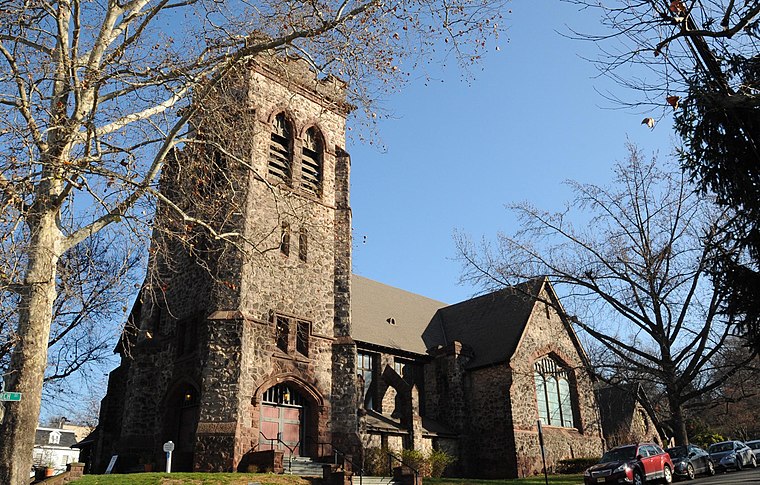
Photo: KLOTZPLATE, CC BY-SA 4.0.
St. Paul's Episcopal Church is located at 113 Engle Street at the corner of Church Street in Englewood, in Bergen County, New Jersey, United States. St. Paul's Episcopal Church is situated 1 mile southeast of Dwight Morrow High School.
Holy Name Medical Center
Hospital
Holy Name Medical Center is a fully accredited, not-for-profit healthcare facility based in Teaneck, Bergen County, New Jersey, United States, with off-site locations throughout Bergen, Hudson, and Passaic counties. Holy Name Medical Center is situated 2 miles southwest of Dwight Morrow High School.
Localities in the Area
Englewood

Photo: KLOTZPLATE, CC BY-SA 4.0.
Englewood is a city in Bergen County, New Jersey. It borders on Fort Lee and Englewood Cliffs to its east, Tenafly to its north, Teaneck to its west, and Leonia to its south.
West Englewood
Neighborhood
West Englewood is an unincorporated community located within Teaneck in Bergen County, in the U.S. state of New Jersey.
Bergenfield
Town
Photo: Squirrel 22, Public domain.
Bergenfield is a borough in Bergen County, in the U.S. state of New Jersey. Bergenfield is situated 1½ miles northwest of Dwight Morrow High School.
Dwight Morrow High School
- Type: School
- Description: high school in Englewood, New Jersey
- Categories: high school and education
- Location: City of Englewood, Bergen County, Gateway, New Jersey, Mid-Atlantic, United States, North America
- View on OpenStreetMap
Latitude
40.9076° or 40° 54' 27" northLongitude
-73.98264° or 73° 58' 58" westElevation
62 feet (19 metres)Open Location Code
87G8W258+2WOpenStreetMap ID
node 357725949OpenStreetMap Feature
amenity=schoolGeoNames ID
5097378Wikidata ID
Q5318218Dwight Morrow High School Satellite Map
© OpenStreetMap, Mapbox and Maxar
Also Known As
- Arabic: ثانوية دوايت مورو
- Catalan: Dwight Morrow High School
- French: Dwight Morrow High School
- Slovenian: Dwight Morrow High School
- Spanish: Escuela secundaria Dwight Morrow
- Swedish: Dwight Morrow High School
- Morrow High School
Localities in the Area
- Tryon ParkNeighborhood
- Knickerbocker ParkNeighborhood
- Monument CircleLocality
- Rugby SquareNeighborhood
- TenaflyTown, 1½ miles northeast
Places in the Area
- Janis E Dismus Middle SchoolSchool, 930 feet southwest
- Dr. Leroy McCloud Elementary SchoolSchool, 2,600 feet east
- Dr. John Grieco Elementary SchoolSchool, 3,200 feet east
- Ivy Lane ApartmentsResidential area, 3,500 feet northwest
- Saint Cecilias SchoolSchool, 3,600 feet southeast
Popular Destinations in Bergen County
Discover Hackensack, East Rutherford, Fort Lee and Englewood.
Escape to a Random Place
Discover other destinations in the world.
About Mapcarta. Thanks to Mapbox for providing amazing maps. Data © OpenStreetMap contributors and available under the Open Database License. Text is available under the CC BY-SA 4.0 license, excluding photos, directions and the map. Description text is based on the Wikipdia page Dwight Morrow High School. Photo: Maroonraider, Public domain.