Las Palmas Air Base
Las Palmas Air Base is a military airport in Santiago de Surco District, city of Lima, Peru. It is administered by the Peruvian Air Force, one of three branches of the Peruvian Armed Forces.Notable Places in the Area
Blériot XI
Memorial
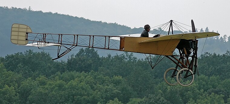
Photo: Kogo, CC BY-SA 3.0.
The Blériot XI is a French aircraft from the pioneer era of aviation.
Hawker Hunter
Memorial
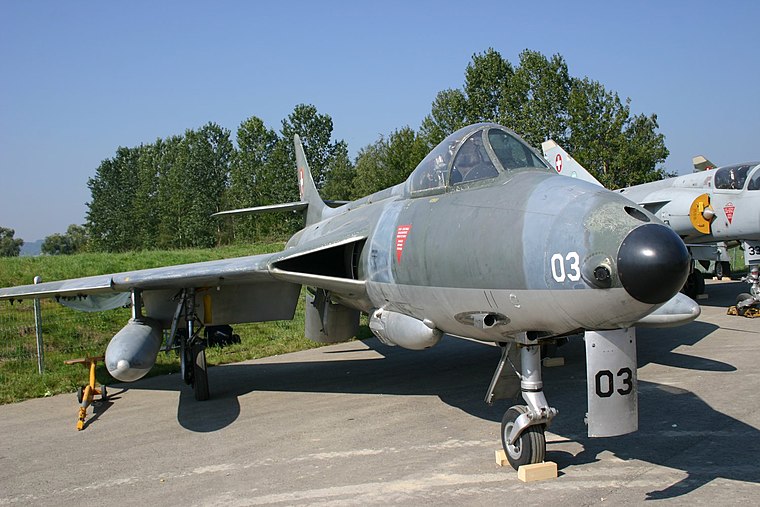
Photo: Wikimedia, CC BY-SA 2.5.
The Hawker Hunter is a transonic British jet-powered fighter aircraft that was developed by Hawker Aircraft for the Royal Air Force during the late 1940s and early 1950s.
Dassault Mirage 5
Memorial

Photo: Wikimedia, Public domain.
The Dassault Mirage 5 is a French supersonic attack aircraft designed by Dassault Aviation during the 1960s and manufactured in France and a number of other countries.
Localities in the Area
Miraflores
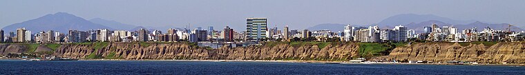
Photo: tafs, CC BY-SA 2.0.
Miraflores is a suburb or barrio of Lima the capital city of Peru.
East Lima

Photo: Harleyca, CC BY-SA 3.0.
Eastern Lima describes the districts of La Molina, Cieneguilla, Ate Vitarte, Santa Anita, San Juan de Lurigancho, Lurigancho-Chosica, Chaclacayo in Lima, Peru.
Las Palmas Air Base
- Type: Aerodrome
- Description: airport in Peru
- Categories: air base and transportation
- Location: Santiago de Surco, Lima, Lima region, Peru, South America
- View on OpenStreetMap
Latitude
-12.162° or 12° 9' 43" southLongitude
-77.0002° or 77° 0' 1" westElevation
61 metres (200 feet)ICAO airport code
SPLPOpen Location Code
57V4RXQX+5WOpenStreetMap ID
node 1042080996OpenStreetMap Feature
aeroway=aerodromeGeoNames ID
3936721Wikidata ID
Q5721609Las Palmas Air Base Satellite Map
© OpenStreetMap, Mapbox and Maxar
Also Known As
- Cebuano: Las Palmas
- Chinese: 拉斯帕爾馬斯機場
- English: Las Palmas
- English: Las Palmas Airport
- English: SPLP
- Indonesian: SPLP
- Japanese: ラス・パルマス空軍基地
- Malay: Lapangan Terbang Las Palmas
- Spanish: Base aerea Las Palmas
- Spanish: Base aérea Las Palmas
- Aeropuerto Las Palmas
Localities in the Area
- San Francisco de AsisNeighborhood
- San PedroNeighborhood
- Bayer SurcoNeighborhood
- SagitarioNeighborhood
- AlegreNeighborhood
Landmarks in the Area
- Base Aérea Las PalmasAerodrome
- Parque CoovisanPark
- Avenida Coronel Edmundo Aguilar Pastor
- Parque EneasPark
- Parque AriadnaPark
Popular Destinations in Peru
Discover Lima, Machu Picchu, Cuzco and Arequipa.
Escape to a Random Place
Discover other destinations in the world.
About Mapcarta. Thanks to Mapbox for providing amazing maps. Data © OpenStreetMap contributors and available under the Open Database License. Text is available under the CC BY-SA 4.0 license, excluding photos, directions and the map. Description text is based on the Wikipdia page Las Palmas Air Base. Photo: Galeria del Ministerio de Defensa del Perú, CC BY 2.0.