


 PLACETAS, CUBA, KNOWN AS THE ‘VILLA OF THE LAURELS’. PHOTOS/ VIDEOS.
Placetas (Spanish pronunciation: [plaˈsetas]) is a city in the Villa Clara Province in the center of Cuba; before the change in the country’s government in 1959, the province was called Las Villas. The town is also known as La Villa de Los Laureles because of its wild laurel trees. Placetas is also a Municipio, one of 13 subdivisions of the Villa Clara Province. Cuba’s geographical center, Guaracabulla, is located in this municipality.
https://youtu.be/VCVWtEAMw7Q
(Press ^ Here)
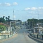
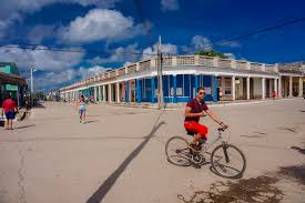
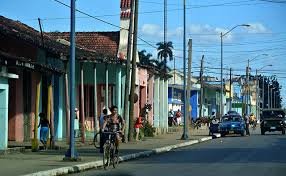
Placetas, Cuba.
HISTORY
Placetas was founded on September 9, 1861, mainly due to the sugar production industry. Nowadays, the main produce of the area is tobacco. The main contribution to its foundation came from Jose Martinez-Fortun y Erles, a Spanish Marques and former colonel in the Spanish Army. The town is located on the Carretera Central road, which cuts through the town. The town’s position on this road has allowed it to serve as a stop for many travelers. Placetas has grown considerably over the years, being declared a town in 1881 and a city in 1925. In 1879 it was established as its own municipality. Placetas is also known for the great carnivals which take place in July and Christmas and New Year’s Eve.
Until the 1977 administrative reform, Placetas was divided into the following barrios: Cabecera (Placetas town proper), Guaracabulla (or Guaracabuya), Hernando, Nazareno, San Andres, Sitio Potrero, and Tibisial. Annual celebrations displaying the local pride of each barrio used to take place until the 1990s when the government stopped them.

GEOGRAPHY
Placetas lies southwest of its province, next to the borders with the one of Sancti Spíritus. Nearest towns include Zulueta (to the north), Remedios (to the northeast), Cabaiguán and Fomento (to the east), and Santa Clara and Camajuaní (to the west). The springs of Zaza River, which runs from the outskirts of Placets to the sea, are located near the town. The river Zaza is currently an environmental preservation area.
The municipality borders with Manicaragua, Santa Clara, Camajuaní, Remedios, Cabaiguán and Fomento. Its territory includes the villages of Báez, Benito Juárez, Carbó Serviá, Falcón, Falero, Guaracabulla, Hermanos Ameijeiras, Manzanares, Máximo, Miller, Nazareno, Oliver and Suazo.
DEMOGRAPHICS
In 2004, the municipality of Placetas had a population of 71,837. With a total area of 601 km2 (232 sq mi),[2] it has a population density of 119.5/km2 (310/sq mi). The city proper has a population of 42,000.
ECONOMY
This section does not cite any sources. Please help improve this section by adding citations to reliable sources. Unsourced material may be challenged and removed. (August 2016) (Learn how and when to remove this template message)
The area is primarily a sugar-producing region, with three “centrales” sugar producing factories. Placetas also has major railroad industries that operate from its area. Many Placetenos have emigrated to other countries and there are around 2300 people from Placetas residing in the United States, most of them in Miami. This contributes to the high amount of comunitarios that travel to Placetas every month from the United States. Nowadays the town also houses many aluminum factories and is known around Cuba as the capital of aluminum because of the export business. One of the main streets in Placetas is the Primera del Oeste street, because is the corner where Cuba’s central road and the Parque Casallas meet and because it houses the popular Rumbos, one of the many touristic places recently opened. This street also houses the underground commerce and business of the town. It is referred to by Placeteños as La Calle 8 de Placetas, in reference to 8th St. in Miami.
ARCHITECTURE
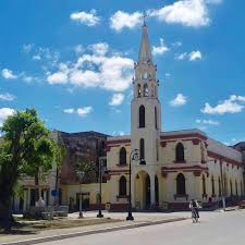
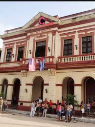
The main Catholic church in the town is called San Atanasio de Placetas, after the town’s patron saint. As of 1996, it had one library, the main post office, three middle-high schools (13 de Marzo, Rodolfo Leon Perlacia, and Julio Antonio Mella), one police station, and many recreational areas. Most of the downtown’s structures were built before the 1959 government of Fidel Castro, and little of the town has been renovated since.
NOTABLE PEOPLE
Miguel Díaz-Canel (b. 1960), President of Cuba since 2018; Pepin Garcia (b. 1950), Cuban-American businessman; Emilio Mola (1887-1937), Spanish-born general and instigator of the Spanish Civil War; Alberto Rojas Espinoza (1868-1912), colonel of Cuban Liberation Army during Cuba’s 1895 War of Independence from Spain and mayor of the municipality in 1901 and 1912.

![]()
 PLACETAS, CUBA, CONOCIDA COMO LA ‘VILLA DE LOS LAURELS’. FOTOS Y VIDEOS.
Placetas es una ciudad en la provincia de Villa Clara en el centro de Cuba; antes del cambio de gobierno del país en 1959, la provincia se llamaba Las Villas. El pueblo también es conocido como La Villa de Los Laureles por sus laureles silvestres. Placetas es también un Municipio, una de las 13 subdivisiones de la provincia de Villa Clara. En este municipio se encuentra el centro geográfico de Cuba, Guaracabulla.
https://youtu.be/VCVWtEAMw7Q
(Presione ^ Azul)
Placetas, Cuba.
HISTORIA
Placetas fue fundada el 9 de septiembre de 1861, principalmente debido a la industria azucarera. Hoy en día, el principal producto de la zona es el tabaco. La principal contribución a su fundación provino de José Martínez-Fortún y Erles, un marqués español y ex coronel del Ejército español. El pueblo está ubicado en la Carretera Central, que atraviesa el pueblo. La posición del pueblo en esta vía ha permitido que sirva de parada a muchos viajeros. Placetas ha crecido considerablemente a lo largo de los años, siendo declarada villa en 1881 y ciudad en 1925. En 1879 se constituyó como municipio propio. Placetas también es conocida por los grandes carnavales que tienen lugar en julio y Navidad y Nochevieja.
Hasta la reforma administrativa de 1977, Placetas estaba dividida en los siguientes barrios: Cabecera (ciudad de Placetas propiamente dicha), Guaracabulla (o Guaracabuya), Hernando, Nazareno, San Andrés, Sitio Potrero y Tibisial. Las celebraciones anuales que mostraban el orgullo local de cada barrio solían tener lugar hasta la década de 1990, cuando el gobierno las detuvo.
GEOGRAFÍA
Placetas se encuentra al suroeste de su provincia, junto a los límites con la de Sancti Spíritus. Los pueblos más cercanos incluyen Zulueta (al norte), Remedios (al noreste), Cabaiguán y Fomento (al este) y Santa Clara y Camajuaní (al oeste). Los manantiales del río Zaza, que corre desde las afueras de Placets hasta el mar, se encuentran cerca de la ciudad. El río Zaza es actualmente un área de preservación ambiental.
El municipio limita con Manicaragua, Santa Clara, Camajuaní, Remedios, Cabaiguán y Fomento. Su territorio comprende las localidades de Báez, Benito Juárez, Carbó Serviá, Falcón, Falero, Guaracabulla, Hermanos Ameijeiras, Manzanares, Máximo, Miller, Nazareno, Oliver y Suazo.
DEMOGRAFÍA
En 2004, el municipio de Placetas tenía una población de 71.837. Con un área total de 601 km2 (232 millas cuadradas), [2] tiene una densidad de población de 119,5 / km2 (310 millas cuadradas). La ciudad propiamente dicha tiene una población de 42.000 habitantes.
ECONOMÍA
Esta sección no cita ninguna fuente. Ayude a mejorar esta sección agregando citas a fuentes confiables. El material no obtenido puede cuestionarse y eliminarse. (Agosto de 2016) (Obtenga información sobre cómo y cuándo eliminar este mensaje de plantilla)
El área es principalmente una región productora de azúcar, con tres fábricas productoras de azúcar “centrales”. Placetas también tiene importantes industrias ferroviarias que operan desde su área. Muchos placetenos han emigrado a otros países y hay alrededor de 2300 personas de Placetas que residen en los Estados Unidos, la mayoría en Miami. Esto contribuye a la gran cantidad de comunitarios que viajan a Placetas todos los meses desde Estados Unidos. Hoy en día, la ciudad también alberga muchas fábricas de aluminio y es conocida en Cuba como la capital del aluminio debido al negocio de exportación. Una de las calles principales de Placetas es la calle Primera del Oeste, porque es la esquina donde se unen la vía central de Cuba y el Parque Casallas y porque alberga los populares Rumbos. Esta calle también alberga el comercio subterráneo y los negocios de la localidad. Placeteños se refiere a ella como La Calle 8 de Placetas, en referencia a 8th St. en Miami.

ARQUITECTURA
La principal iglesia católica de la ciudad se llama San Atanasio de Placetas, en honor al santo patrón de la ciudad. A partir de 1996, contaba con una biblioteca, la oficina principal de correos, tres escuelas secundarias (13 de Marzo, Rodolfo León Perlacia y Julio Antonio Mella), una comisaría y muchas áreas recreativas. La mayoría de las estructuras del centro se construyeron antes del gobierno de Fidel Castro en 1959, y desde entonces se ha renovado poco de la ciudad.

GENTE NOTABLE
Miguel Díaz-Canel (n. 1960), presidente de Cuba desde 2018; Pepin García (n. 1950), empresario cubanoamericano; Emilio Mola (1887-1937), general de origen español e instigador de la Guerra Civil española; Alberto Rojas Espinoza (1868-1912), coronel del Ejército de Liberación de Cuba durante la Guerra de Independencia de Cuba de 1895 y alcalde del municipio en 1901 y 1912.
Agencies/ Wiki/ Internet Photos/ Arnoldo Varona/ www.TheCubanHistory.com
THE CUBAN HISTORY, HOLLYWOOD.

![]()
