

BAY Parkway, which slots in between 21st and 23rd in the list of southwest Brooklyn avenues from 1 to 28, and I have had an off and on relationship. Oddly enough, 22nd Avenue is the only missing number. While I never bicycled it during my 35-year Brooklyn tenancy between 1957 and 1993 ( I usually plowed through Bensonhurst east to west, not north and south) it was never a destination.
When the Belt Parkway was opened in 1940, Robert Moses, in a rare accommodation to cyclists and pedestrians, provided a path by the Narrows that stretched from Bay Ridge Avenue (called 69th Street by one and all in Bay Ridge) to Bay Parkway. When accessing the path via 4th Avenue, I could go north or go south. Sometimes I would go to 69th Street and if I was feeling my Wheaties that day, I’d reverse and go all the way back to Bay Parkway, then back to 4th Avenue and then home (I had 4 separate homes in Bay Ridge/Dyker Heights between 1957 and 1993). One thing I had to do a lot is dismount at 4th Avenue because the access path to 4th Avenue was steep indeed. On a couple of occasions I could bicycle it if the wind was right.
So, Bay Parkway, other than the stretch between the Narrows and the Belt Parkway, was new to me…
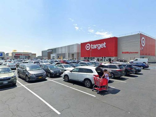
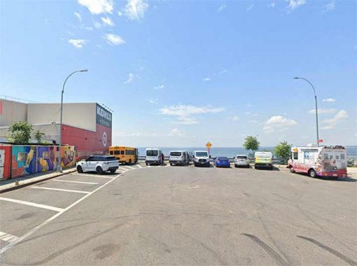
…because when I was a kid my parents occasionally visited the E.J. Korvette at the south end of Bay Parkway for a housewares run instead of our usual trip to A&S, now Macy’s, on Fulton Street. After Korvette started shutting down its stores and declared bankruptcy, its Bay Parkway location became the deliberately misspelled Ceasar’s Bay Bazaar in1982. After 14 years, Ceasar’s Bay begat K-Mart (the former Kresge’s) which in turn also went out of business. Today, the vast field is anchored by Target, Kohl’s, Bob’s Discount Furniture … and an Olive Garden, in this formerly mostly Italian neighborhood.
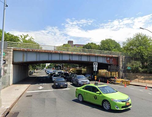
If the photos of Bay Parkway south of 86th Street look a lot sunnier than the others, I cheated and used Street View. The day of my walk it was a solid gray overcast as has been much of the spring in NYC. I didn’t want to head south from 86th Street, turn around and retrace: Bay Parkway is long enough as is. Here it is passing beneath the Belt Parkway.


One question that has puzzled me for awhile is, why “Bay Parkway”, why not 22nd Avenue? The road was constructed in the final years of the 19th Century, along with its fellow avenues and numbered streets in southwest Brooklyn. The king of Bay Ridge research, Henry Stewart, provided me with a few clips from the Brooklyn Standard Union in 1891-1892 and the road was christened Bay Parkway around that time.
The city of Brooklyn had plans for it to resemble a true parkway, like Ocean or Eastern Parkway, connected to Ocean Parkway from the start and was built wide. At one time, presumably, it was overshadowed by shade trees. But the Auto Age had other plans for it, and it became a major throughway a la Fort Hamilton Parkway and Bay Ridge Parkway (75th Street).

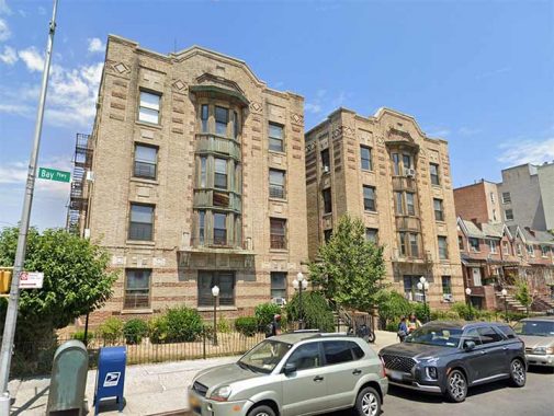
These attached homes are on a street originally called Bay View Place, just east of Bay Parkway, and are a complete puzzle to me. Why? Today, they sit on a westbound off ramp of the Belt Parkway and, as far as I can ascertain, an owner of a vehicle in one of those buildings needing to park there (notice the parked vehicles) would need to travel south on Cropsey Avenue, enter the Belt at Bay 50th Street, over a mile away, and exit on this ramp. Am I right? See for yourself.
The story I seem to remember (perhaps Robert Caro has it in “The Power Broker”) is that Robert Moses was stymied when the owners of these buildings refused to sell and so he built an exit ramp to run alongside them, out of spite. I wouldn’t put it past him.

Bensonhurst Park, a rough square between 21st Avenue and Bay Parkway, Cropsey avenue and the Belt Parkway, is one of Brooklyn’s oldest parks and the largest park in either Bath Beach or Bensonhurst (much of Dyker Beach Park is taken up by the golf course).
The city of Brooklyn purchased approximately 16 acres of land from the Benson and Lynch families in 1895 for Bensonhurst Park. There are still some older wood and concrete benches here and there.
In the Swingin’ Sixties my parents and I would pass the park on our periodic visits to E. J. Korvettes. We would take the B64 bus from 86th Street to Bay Parkway and Bath Avenue and walk to the end of the parkway. In 2010 the B64’s route was dramatically changed and it now runs from Shore Road and 71st Street to Coney Island, as it has done for countless years. There is no longer a direct bus route from the 86th Street shopping district between 4th avenue and Fort Hamilton Parkway: a transfer from the B1 to the B64 is necessary at 14th Avenue.

At Bay Parkway, Cropsey Avenue gains a couple of extra lanes and a center median. It wasn’t originally built that way; the late 20s and early 30s saw a lot of roadway construction in Brooklyn, as Kings Highway was widened into a throughway east of Ocean Avenue, Linden Boulevard was built through southern East New York and connected to other roads in Queens, and Cropsey and Stillwell Avenue were widened to their present sizes (in 1931, Cropsey and Harway Avenues switched names presumably for continuity’s sake because of the widening).

What looks like an old sign at Kay’s Pharmacy, Cropsey Bath Avenue at Bay Parkway. It has the once ubiquitous Rx “recipe” symbol and the “vessel with the pestle.”
Handsome early 20th Century apartment house, not the last one we’ll see, at Benson Avenue and Bay Parkway. The avenue is named for Egbert Benson, a nephew of the first Egbert Benson (1746-1833), New York State’s first attorney general. The Benson family had numerous real estate holdings in what became the neighborhood named for it. One of Manhattan’s One and dones,” Benson Street, is also named for the attorney general, whon is interred in Jamaica’s Prospect Cemetery, one of NYC’s oldest burial grounds.


In a non-landmarked district, different philosophies of building design can abut each other.


The Belt Parkway West End BMT (D) station opened, along with other elevated stations on 86th Street, at the end of 1916. It’s one of a handful of BMT and IRT stations that were clad in concrete with terra cotta detailing, what I call “monumental els.” an interesting feature is the mini-arches above the pedestrian crossings. Elswehere, the station is equipped with the same platform benches found at the Queensboro Plaza station.


Bay Parkway is important enough to have gotten three separate subway stops, on the West End (D), Sea Beach (N) and Culver (F). Originally, all were called “22nd Avenue” and then “22nd Avenue-Bay Parkway.” The 1968 map shows the Culver was the last to lose that “22nd Avenue” signage.


From the platform at Bay Parkway, this ancient sign for Orloff’s, established, as it says, in August 1902 at 2211 86th, is visible. Gravesend historian Joseph Ditta: According to this advertisement from the program for the Annual Fair of the Epworth League of the Cropsey Avenue Methodist Episcopal Church, August 19-21, 1909, Orloff’s sold dry goods, gents’ furnishings, and shoes.
As an aside, FNY’s 86th Street in Bensonhurst page for whatever reason is the most-commented on to date, with over 500! Keep it going…

The Chase branch at Bay Parkway and 85th Street has a pair of semi-ornamental “bank lamps’ placed outside to discourage overnight break-ins and robberies.


Like 4th Avenue in Bay Ridge, which I think Bay Parkway resembles a great deal, portions of Bay Parkway are lined with huge apartment houses, many in the Art Moderne of Art Deco style, which means they were constructed in the late 1920s to early 1930s.


Between 81st and 82nd Streets, there’s a break on the wall of apartment houses with the Episcopal Church of the Holy Spirit, now accommodating a Chinese congregation. A private dwelling with the same stone classing is next door and may well have been the church’s parsonage. Two dates, 1897 ande 1909, aree seen near the entrance marking the dates of the congregation’s founding and the construction of the building itself.


In my memory, Bensonhurst has been a South Asian and to some degree, Russian neighborhood, and before that nearly overwhelmingly Italian. But before that, Bensonhurst was heavily Jewish like its sister neighborhood Borough Park. That legacy is kept alive by a number of temples and synagogues on Bay Parkway’s southern stretch.


“Brooklyn’s Mother Road,” Kings Highway, begins at Bay Parkway and 78th Street, and doesn’t stop till it gets to East 98th Street at the doorstep of Brownsville, from Bensonhurst to Gravesend to Midwood to East Flatbush. I have walked its length in two sections and discussed its history that you can access in the link in this paragraph.
Did you know that Kings Highway used to extend all the way west to the present intersection of 86th Street and Fort Hamilton Parkway? That stretch disappeared as the overall Dyker Heights/Bensonhurst street grid was built up, but there are hints of its former existence, such as the wide section of 84th Street between 16th and 18th Avenues and also that Kings Highway’s street numbering begins at #82 instead of #2 on the south side of the street, implying that at one time there was a western section that had lower house numbers. Sergey Kadinsky discusses the “lost” Kings Highway section on this page.

When trying to type “Hylan Boulevard” when writing Staten Island FNY pages, I often subconsciously or automatically include a “d” at the end, and it appears that bus billboard designers do it, too.
Where Brooklyn Worlds Collide


Two blocks north of Kings Highway, a number of major Brooklyn routes come together, where Bay Parkway is met by Bay Ridge Parkway (75th Street) from the northeast, Avenue P from the west and Stillwell Avenue from the south. The triangle formed by Bay Parkway, Avenue P and Stillwell is Bealin Square, named for James Bealin, the first Bensonhurst resident killed in World War I. The square was named in 1927 but gets no respect from the Department of Transportation, as the street sign has been sun-bleached into illegibility. Meanwhile, the westernmost block of Avenue P was named for Frank Pershep, an area resident who, according to Gil Tauber, worked for Aon Corporation at the World Trade Center and was killed in the terrorist attack of September 11, 2001.
Why do Brooklyn worlds collide here? Look at the street map. Stillwell Avenue, and Bay Parkway north to 65th Street, form an undefended boundary between Brooklyn street patterns. To the west is the Brooklyn City pattern, formulated before Brooklyn joined NYC in 1898, of north-south numbered avenues and east-west numbered streets. To the east is the Town of Flatbush scheme, with lettered east-west avenues and East and West numbered streets that run north to south but are east and west of McDonald Avenue. Today, and since 1898, they’re all on the same team in the borough of Brooklyn.
Avenue P is one of three of the lettered avenues to intersect Bay Parkway. The other is Avenue O, a block north. What’s the other one? I’ll get to that.


Seth Low is the bigger of the two parks at the confluence of roads, filling a rhomboid between Bay Parkway, Avenue P, Stillwell Avenue and West 12th Street. It’s the largest park between Dyker Beach and Marine Parks, and there’s room enough for kiddie swings, basketball and mah-jongg. Why is betting on it illegal? Were I inclined, I can bet on the NBA semifinal or any other sport with an app on my Iphone.
Seth Low (1850-1916) was Mayor of the independent city of Brooklyn, achieving a number of reforms, from 1881-1884, president of Columbia University from 1890-1901 and Mayor of NYC from 1902-1904. Before 1895, Seth Low Park was the site of a large pond that was eventually filled in with construction ash.

A fanciful entrance, Pershing Arms, coner Bay Parkway and Avenue O.

I know a Colgan when I see one. For years, ex-firefighter John Colgan has been beautifying older fire alarms (known as V.F. Pedestals) by repainting them in a palette of red, white, blue and gold.


Though Bay Ridge Avenue (69th Street) is a two-way route of moderate importance in Bay Ridge, at its southeastern end at Bay Parkway in Bensonhurst, it’s another one-way side street, but it ends at a classic apartment building and a pasticceria with handsome painted and neon signs. Tis a pity I can’t eat the foods displayed in bakery windows too often.


Though stations on the open-cut Sea Beach line (N train) are generally standalone buildings with plenty of tiling and terracotta, the Bay Parkway station, opened as part of the Dual Contracts subway line in June 1915 (it was formerly a surface steam RR passenger line instituted in 1877), cleverly disguises itself as a storefront. Across the street, the railroad cut is more apparent, with an angled building.


This stretch of Bay Parkway, in the 60s, has come to resemble 8th Avenue in Sunset Park, with plenty of Chinese script on the awning signs.


Another pair of Bay Parkway’s massive apartment buildings at 64th and 62nd Streets.


St. Athanasius Roman Catholic Church occupies real estate on both sides of Bay Parkway between 61st and 62nd Streets. The school, on the west side, boasts icons of Christ the King, Michael the Archangel (who seems to be slaying the dragon St. George was reported to have killed), Padre Pio, Our Lady of Fatima, and as far as I can ascertain, the only icon of Mother Teresa. Flags of the Vatican City colors, yellow and white, are also on view.
Athanasius was a great theologian of the early Church:
Bishop of Alexandria; Confessor and Doctor of the Church; born c. 296; died 2 May, 373. Athanasius was the greatest champion of Catholic belief on the subject of the Incarnation that the Church has ever known and in his lifetime earned the characteristic title of “Father of Orthodoxy”, by which he has been distinguished ever since. While the chronology of his career still remains for the most part a hopelessly involved problem, the fullest material for an account of the main achievements of his life will be found in his collected writings and in the contemporary records of his time. He was born, it would seem, in Alexandria, most probably between the years 296 and 298. [New Advent]


St. Athanasius Church occupies the parcel on the east side of Bay Parkway between 61st and 62nd Streets; the church combines St. Athanasius and the defunct St. Dominic parishes. The parish was established in 1913 with the present church dedicated in 1962. The exterior features a mosaic representation of St. Athanasius and symbols of the 12 Apostles.
Do the apostles have symbols? They do:
Simon (a fish and a book; the apostles were ‘fishers of men’ through the Gospel)
Jude (a ship, to represent his missionary journeys across bodies of water)
John (a cup holding a snake; according to legend, John once blessed a cup of poisoned wine he was given to drink at a feast in Ephesus, and the poison departed the cup in the form of a snake)
Thomas (a carpenter’s square and spear; he supposedly built a church by himself in India, while he was martyred with a spear)
Matthew (three bags of money; his first career was as a tax collector)
Peter (two crossed keys; as the first leader of the Church, Peter was given the authority of the Church or “keys to the kingdom”)
James the Less (Often represented by a saw, or in other representations, a fuller’s pole. Though tradition holds he was martyred by stoning, another story says he was clubbed in the head by a fuller’s pole, formerly used in cloth manufacturing)
Philip ( a cross and two loaves of bread, perhaps reminiscent of the Miracle of Loaves and Fishes)
Bartholomew (Tradition holds he was martyred in Armenia by being flayed, or having his skin cut off, while alive. His symbol is a knife accompanied by a book symbolizing the gospel)
James the Greater (three seashells symbolizing the coast of Spain, where he preached)
Andrew (fish on an X-shaped cross; he was supposedly martyred on one. The fish is a symbol of Christ, from its Greek name, ichthys, which contains an anagram, in Greek, of honorifics given to Jesus, explained on this page.)
Matthias (he was chosen after Judas Iscariot’s betrayal; his means of martyrdom was murder by ax)


Modern, or 21st Century architecture, is mostly absent from the north end of Bay Parkway, except for this new medical offices building at 61st Street and the Cubist apartment tower 60Bay, at 60th Street. I do have a soft spot for large windowed apartments, but I’m not sure venetian blinds (my window covering of choice) are made large enough to accommodate the windows, as I can’t see any blinds on the windows.


While Green-Wood and perhaps Evergreens get all the Brooklyn cemetery publicity, there’s another one smack in the center of the borough that’s fairly unnoticed, except if you are looking out the window of the F train en route to Coney Island or toward Manhattan. Washington Cemetery has been in Kings County since the early 1850s, making it only a few years younger than Green-Wood, and while it has a primarily Jewish clientele today, that wasn’t always the case; cemetery founder James Arlington Bennett is interred within. He was also an educator and ran for Vice-President in 1840 on a ticket with Joseph Smith, author of the Book of Mormon and founder of the Church of Latter-Day Saints.
The cemetery is divided into five separate numbered cemeteries divided by 20th and 21st Avenue, Bay Parkway, McDonald Avenue and Ocean Parkway. Cemetery #1 is east of McDonald Avenue and #2-5 are between McDonald and 19th Avenue. The main entrance, and its marvelously Victorian office building, is on Bay Parkway near McDonald Avenue.
You won’t find a lot of big names here, but Jerry Sterner (1938-2001), author of the play “Other People’s Money” is here; his headstone reads “Finally, a plot.”


The third of Bay Parkway’s subway/el stations is on the BMT Culver Line, which like the Sea Beach and West End, began as a surface steam RR serving the southern reaches of Kings County. The original railroad was founded by Andrew Culver in 1875 and was converted to a third rail elevated in 1919. It was the last Bay Parkway station to dispense with “22nd Avenue” platform signage.
Bay Parkway plows ahead to Ocean Parkway and thus meets the north-south Flatbush side streets t an angle. And once past the cemetery…


… as it enters the semisuburban reaches on the border of Parkville and Midwood. Freestanding private homes, some with expansive interior porches, can be found on Bay Parkway which here is lined with an array of old-growth oaks.


Avenue J is the only other lettered avenue besides O and P that is met by Bay Parkway, now fully within the Flatbush street layout scheme. The triangle formed by Bay Parkway, Avenue J and East 5th Street marks Parkville’s war memorial for local heroes. Several blocks east on Avenue J, at East 16th Streets, you will find DiFara’s, noteed by some as Brooklyn’s finest pizza.

Traffic headed for the south Ocean Parkway roadway is directed to turn right on Avenue J and another right onto the O.P., as Bay Parkway eastbound connects only to the Ocean Parkway service road.
That’s Bay Parkway, and I’m hoping for less murk for my next adventure.
As always, “comment…as you see fit.” I earn a small payment when you click on any ad on the site. Take a look at the new JOBS link in the red toolbar at the top of the page on the desktop version, as I also get a small payment when you view a job via that link.
5/12/24
9 comments
An even bigger issue for the houses on Bay View Place is that commercial vehicles, such as delivery vehicles and contractors’ trucks, cannot readily go directly in front of them because they aren’t allowed on the Belt. I suppose they’d have to (awkwardly) back in from 86th.
You mean back in from Bay Pkwy. I suspect that’s how the parked cars got there.
Commercial traffic is allowed for a distance of 1 exit. that happens more than you would think, for example to get to and from the riding academy.
Another lesser known fact about Bay Parkway, is that there was a semi-pro baseball team named the “Brooklyn Bay Parkways”. The Bay Parkways played up until the late 1940’s at Erasmus Field on McDonald Ave, and
Babe Ruth hit his final home run in professional baseball for the Bay Parkways. The Bay Parkways front office was located on 85th Street between 21st Avenue and Bay Parkway. Searching online, I found a uniform maker from the West Coast that makes replicas of the Bay Parkways u8niforms that features the number “3”, which Babe Ruth wore. New York Giants pitcher, Carl Hubbell also played some games for the Bay Parkways. I also found advertisements in the Brooklyn Eagle looking for opponents to play. During the first half of the 20th century, Brooklyn was full of semi-pro teams like the Bushwicks and numerous Negro League teams, which
the Bay Parkways would play.
Thank you for showing my old territory, I grew up in one of those big apartment houses built in the 1920s, I lived on Bay Parkway between Bath and Benson in the 40s, 50s and early 60s.The demography was mostly Jewish and Italian, our super was first a Norweigian guy, later a Polish guy. We had no Russian or Chinese presence back then, and lily-white except for a black porter who had a rough improvised apartment he was allowed to rig up in a basement room. Our side of the block was mostly Jewish but around the corner on Bay 29th St it was mostly Italian, and we were all friends. I remember Kay’s pharmacy, the druggist was Otto Katz. Diagonally across from Katz was another pharmacist, Joe Gulliner. Down at the end where Kevin remembers Korvette’s and the painfully mis-spelled Ceasar’s Bay was the Cirillo Bros Coal and Coke depot, and I remember our building was heated by a coal furnace. The super shoveled fuel in and the porter hauled the ashes out. We dumped our garbage into a chute which led to an incinerator, and in the late afternoon all the incinerators were burning and spewing smoke. In our building, out of 75 families we had only two Republicans, one of them a committee member we saw at a desk at the polling place, and two families were solid Communist Party. The solid consensus of the Jews and Italians were FDR New Deal and Labor Union supporters. My best friend Bernard was a Red Diaper Baby and his late father had been a prominent member of the City Council, repeatedly reelected on the Communist Party ticket, Peter Cacchione. A minor celebrity who lived across the street in a low-rise apartment row was Richie Andrusco, who appeared as a little boy wandering through Coney Island in the brilliant independent film Little Fugitive. I remember when my building was converted from coal to oil and the incinerator was replaced by a garbage compactor. We paid our rent not to a faceless corporation but to a pair of brothers, and my father’s cousin owned the apartment building down the block. The corner candy store was owned by another of my father’s cousins but he sold it to the father of the guy I introduced Kevin to who went to Brooklyn College with me and later bought the Higgins Mansion on 9th St. There was a little block of old frame houses at the far end of 18th Ave owned by the only black families around, they were said to be descendants of the stable hands from back when Bath Beach was a resort with a racetrack and nice hotels. And yes, the neighborhood rumor was that the exit from the Belt Parkway that runs past those houses was the Spite Ramp built by Robert Moses because they would not sell out to him. I would like to see more info on Old Bath Beach when it was a seaside resort before the Belt Parkway was built on landfill wiping out the beach.
Small correction. Kay’s Pharmacy is on the corner of Bath Ave, not Cropsey Avenue
Oh, let me add: When I was young I remember a pot bellied stove warming up the waiting room of the Bay Parkway station on the West End line. And a sign with a buzzer to alert you to an incoming train.
I have always considered McDonald Avenue to be the median of the east and west numbered streets rather than the bisector mainly due to the fact that the streets don’t cross this one unlike how much of 5th Avenue does that for Manhattan or even Jerome Avenue in The Bronx.
Bay Parkway runs along the border of the former towns of New Utrecht and Gravesend, and Seth Low Park rests on the site of Indian Pond.