As Lake Mead recedes, illegal roads pose new danger to environment, cultural sites
A maze of roads wind across the rocky shores of Lake Mead in a vast spiderweb.
Hundreds of miles of those roads provide official access to Lake Mead National Recreation Area, the nation’s first and largest recreation area and among the most heavily visited national park sites with more than 5.8 million visitors in 2023.
Crisscrossing those roads, however, are hundreds if not thousands of miles more of unofficial tracks.
Problems with illegal roads have plagued Lake Mead National Recreation Area for decades. The park’s 1989 backcountry management plan even warned that “Illegal off-road vehicle travel has caused some of the most significant detrimental impacts to the natural resources in the backcountry of Lake Mead National Recreation Area.”
But in the decades since that management plan was written, the lake’s water levels have lowered significantly, exposing more “new” land as the lake recedes farther and farther from established roads. At the same time, visitation has skyrocketed, with more people than ever seeking access to the lake.
When water levels were higher, an official road reached the lakeshore roughly every 10 miles, providing approximately 60 access points for visitors.
Now, there are only 10 approved roads that reach Lake Mead, half of which are at Boulder Beach, rendering legal backcountry access in many areas of Lake Mead virtually nonexistent.
The National Park Service, the agency that oversees the recreation area, acknowledges that access to the lake is more challenging due to a lack of official roads, but says the rapidly changing shoreline has prevented it from identifying and establishing new, official access points.
Visitors have thus taken it upon themselves to create new roadways, including driving between official roads in attempts to reach isolated points along the water.
“Once someone kind of goes off road, it doesn’t take much in the desert to look like a legitimate road,” Stefani Dawn, who oversees community partnerships and grants for Lake Mead National Recreation Area, told The Nevada Independent.
According to park officials, drivers on those unofficial roads can unknowingly destroy important environmental and cultural resources. And the many drivers who get stuck in muddy land surrounding the lake require assistance, but the unauthorized maze of roads leaves them unable to describe where they are, impeding timely responses by law enforcement and other emergency personnel.
Now, the park service is seeking $8.67 million in funding to help address the illegal roads through the Southern Nevada Public Land Management Act (SNPLMA) — a law passed in 1998 that allows the Bureau of Land Management to sell public lands around Las Vegas for development and dividing revenue from those sales between the state’s education fund, the Southern Nevada Water Authority and the federal government for projects such as conservation and landscape restoration.
“The issues aren’t going to go away unless we take action,” said Shelly Kopinski, director of programs for Get Outdoors Nevada, a nonprofit organization supporting the park service in its efforts to procure funding. “This proposal is the beginning of that.”
‘They just can’t get out’
When full, Lake Mead is the largest reservoir in the country by volume. Despite the vast size of its waterways, most of Lake Mead National Recreation Area is land — 1.5 million acres, or 91 percent — with 942 miles of official paved and dirt roads.
But the lake hasn’t been full in decades.The reservoir’s water level was at its highest in 1983, when it measured 1,225 feet, but since then has steadily receded. By November of last year, the lake was down 160 feet, measuring just 1,065 feet. As the lake’s water level has dropped, “new” land has become exposed — roughly 81,000 acres — and an increased number of visitors have created their own roads while attempting to access the receding water.
The park service has documented 824 miles of illegal roads, although the agency estimates two to three times that many exist. More than 20 percent of those roads — 172 miles — are in the Government Wash area, one of the park’s most popular backcountry camping areas and the closest portion of the recreation area to Las Vegas.
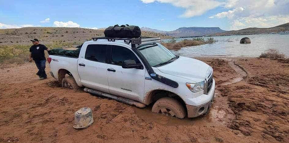
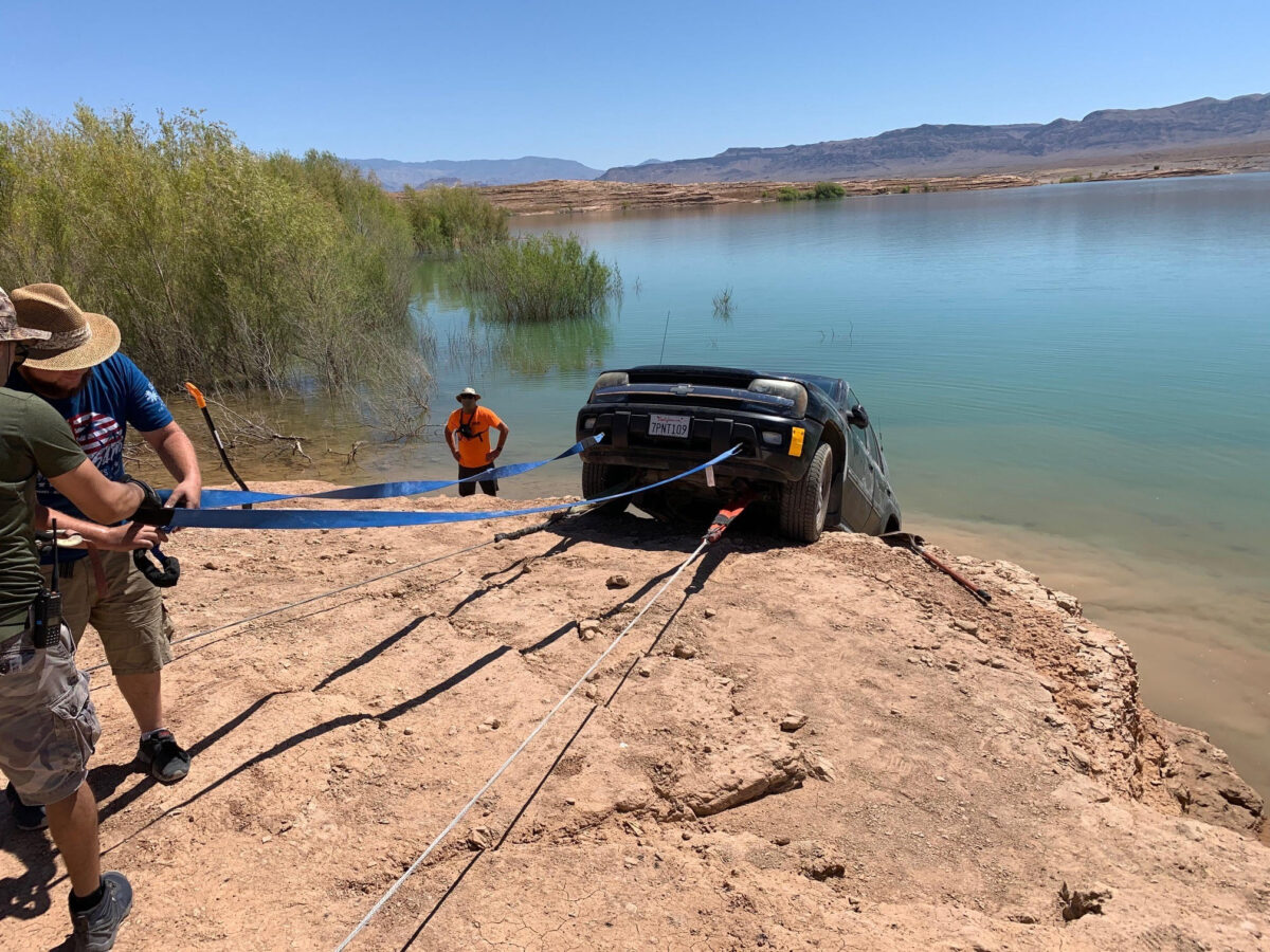
It is also the site of many calls to law enforcement for trapped vehicles.
In 2022, there were 272 calls that required an official response in the Government Wash area, including many vehicle recoveries by law enforcement and the nonprofit organization Southern Nevada Off-Road Recovery (SNORR), according to the park service’s SNPLMA funding application.
The vast majority of SNORR’s recoveries are in the Lake Mead area, said Anthony Duran Peterson, president of the group. Of the 567 extractions the group performed last year, more than 350 were at Lake Mead.
Most of those extractions, he said, were at Government Wash.
“People need to consider what kind of vehicle they have and where they’re taking them,” he said. “It’s people in Honda Accords who don’t realize they’re driving down steep soft sand or gravel trying to get close to the water, and when they try to leave that afternoon they realize they can’t get back up.”
With boat launches closed due to low water levels, some people get stuck trying to back boats and Jet Skis into the water.
“That top crust layer looks like it's dried up, and they don’t realize the water levels have dropped 15, 20 feet,” he said. “By the time they realize they were driving on something that was under water a couple months ago, they are literally up to the frame in mud and they just can’t get out.”
Prior to the current web of illegal roads, there were clear spur roads for law enforcement, volunteers and medical support to quickly reach emergency callers, but the tangle of illegal roads now intertwines with those spurs.
Once-submerged sites at risk
In the Overton Arm area, located in the northern part of the recreation area near Valley of Fire State Park, the park service estimates there are at least 87 miles of documented illegal roads. According to the park service’s application, fewer calls for assistance come in from the Overton Arm area than Government Wash, but some of the roads go through a “highly significant cultural site and rare gypsum soil ecosystems with numerous endangered species.”
Historic and cultural resources in the area include the ghost town of St. Thomas and the Ancestral Puebloan settlement known as the “Lost City.”
St. Thomas was settled in 1865 by members of The Church of Jesus Christ of Latter-day Saints who thought they were in Utah. Featuring a school, post office, grocery store and houses, the town at one time boasted a population of 500 people. When Lake Mead was built, the federal government told residents they must relocate and reimbursed them for their property.
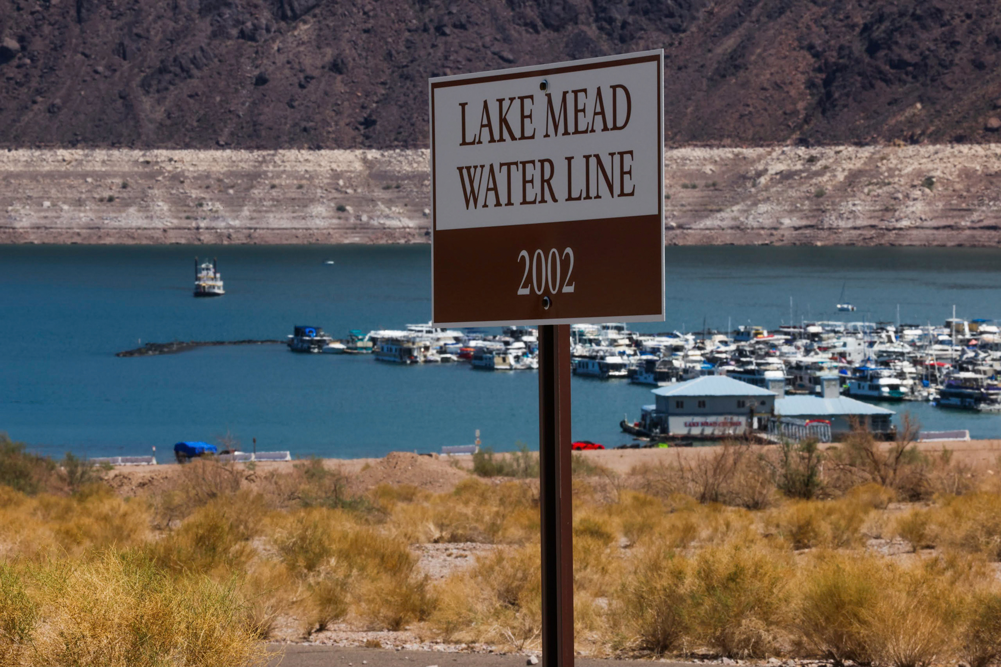
Lake Mead started filling in 1935; in 1938, the last resident left town. At Lake Mead’s highest water level, the town was 60 feet below the surface.
St. Thomas has been exposed continuously since 2002, and the park has adjusted by making access to St. Thomas available through roads and trails, placing educational kiosks about the area’s history near the parking area and along the trail.
Across the river from St. Thomas was an Ancestral Puebloan settlement also lost in the creation of Lake Mead.
Prior to European settlement, the Colorado River area including the Virgin and Muddy rivers in the northern part of Lake Mead were important focal points for Indigenous Americans. Remnants of their once-flourishing settlements, agricultural areas and artwork have been listed on the National Register of Historic Places as Pueblo Grande de Nevada, or the “Lost City.”
Those Indigenous Americans and the remnants of their society are the westernmost examples of Ancestral Puebloan culture in North America, according to JD Lancaster, a geoarchaeologist at the Desert Research Institute.
St. Thomas and Pueblo Grande de Nevada are not the only sites that were swallowed up by Lake Mead. But as the lake’s water level recedes, once-submerged places are reemerging and becoming subjected to additional and sometimes harmful human impacts.
“As the water retreats, there’s historic artifacts that become exposed, like St. Thomas, for example,” Dawn said. “And there are illegal roads in the area.”
Illegal roads present other hazards as well, according to the park service. They create ruts that funnel heavy rain and accelerate erosion, crush and destroy plants and underground animal homes, and increase the risk of vehicles sparking wildfires on dry plants.

Plans, permits and rangers
The agency’s request for $8.67 million in SNPLMA funding would help fund a multiphased approach to address the illegal roads.
Part of the agency’s proposal is to create specific management plans for the Government Wash and Overton Arm areas, as the current 35-year-old backcountry plan governing the recreation area is “broad, vague and extremely outdated,” according to the park service. It does not clearly define where backcountry camping is allowed in the park, nor whether foot or vehicle access is acceptable for backcountry camping in specific locations, according to the park service.
Site-specific plans would help address that lack of clarity, according to the agency. Park officials are also considering implementing a permitting system for camping — either free or paid — and putting location boundaries on backcountry use.
The park does have limits on the number of nights people can camp in the backcountry, but there is no way to enforce those limits or tell how many people are staying overnight in the backcountry.
The park is also considering adding backcountry rangers, positions it does not currently staff.