
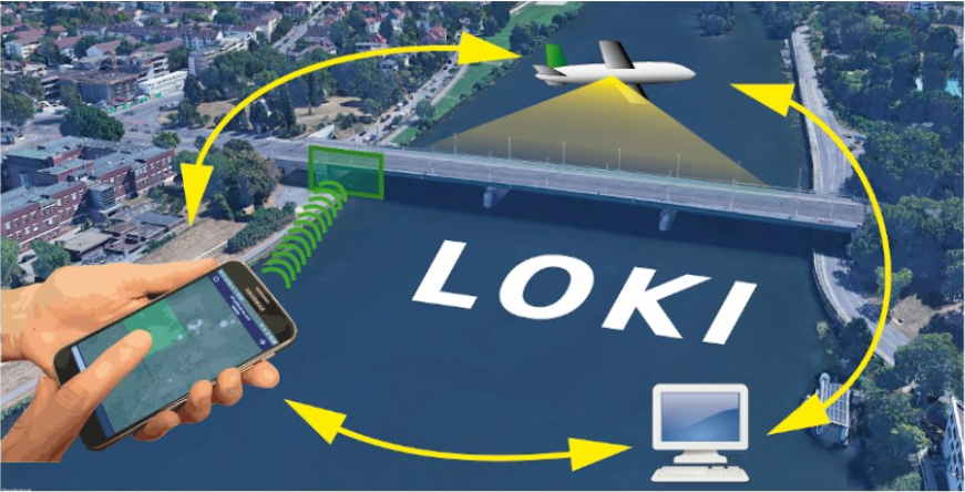
In the aftermath of earthquakes, rapid and accurate assessment of infrastructure damage is crucial. The LOKI project (Airborne Observation of Critical Infrastructures), funded by the Federal Ministry for Education and Research and active from January 1, 2020, to March 31, 2023, aimed to tackle this challenge. Bringing together expertise from diverse research fields including earthquake research, machine learning, crowdsourcing, and Unoccupied Aerial Vehicles (UAVs), LOKI employed an interdisciplinary approach to achieve its goal to enable rapid and reliable airborne-based post-earthquake assessments.
Among its consortium of partners, the research group of Prof. Zipf (GIScience at Heidelberg University) played a central role in developing a micro-mapping approach for evaluating earthquake damage on UAV imagery. Leveraging experience gained from projects like MapSwipe, the GIScience research group contributed crowdsourcing methods to enhance damage mapping efforts by integrating human input into the workflow.
In addition, the LOKI project received support from HeiGIT, which extended the MapSwipe app by a completeness feature enabling the identification of areas where further OSM mapping efforts are required. To accommodate a wider audience and ensure accessibility across different devices and platforms, a web application was implemented alongside the MapSwipe mobile app after the project’s completion. Stay tuned for the upcoming launch of MapSwipe4Web.
For those interested in delving deeper into the LOKI project, a selection of publications and the final project report are available for reference.
Heidelberg University served as the coordinator of the research project, which was a collaboration between several project partners:
- Aeromey GmbH: UAV infrastructure
- FZI Research Center for Information Technology: Coordination mechanisms for UAV fleets
- German Research Center for Geoscience (GFZ): Exposure modeling
- Karlsruhe Institute for Technology (KIT): Earthquake engineering for damage classification
- Heidelberg University, 3DGeo research group: Automatic damage detection and analysis
- Heidelberg University, GIScience research group: Crowdsourcing and user-generated geoinformation
References:
Ullah T, Lautenbach S, Herfort B, Reinmuth M, Schorlemmer D. (2023): Assessing Completeness of OpenStreetMap Building Footprints Using MapSwipe. ISPRS International Journal of Geo-Information. 12(4):143. Assessing Completeness of OpenStreetMap Building Footprints Using MapSwipe
Kohns, J., Zahs, V., Ullah, T., Schorlemmer, D., Nievas, C., Glock, K., Meyer, F., Mey, H., Stempniewski, L., Herfort, B., Zipf, A. & Höfle, B. (2021): Innovative methods for earthquake damage detection and classification using airborne observation of critical infrastructures (project LOKI). In: EGU General Assembly 2021. Vol. EGU21 (EGU21-2712), pp. 1-2. DOI: 10.5194/egusphere-egu21-2712.
Zahs, V., Herfort, B., Kohns, J., Ullah, T., Anders, K., Stempniewski, L., Zipf, A. & Höfle, B. (2021): 3D point cloud-based assessment of detailed building damage through a combination of machine learning, crowdsourcing and earthquake engineering. In: EGU General Assembly 2021. Vol. EGU21 (EGU21-1304), pp. 1-2. DOI: 10.5194/egusphere-egu21-1304.
Zahs, V., Kohns, J., Meyer, F., Schorlemmer, D., Anders, K., Klonner, C., Mey, H., Oostwegel, L., Zadeh, T. & Höfle, B. (2023): LOKI – Luftgestützte Observation Kritischer Infrastrukturen. Schlussbericht. Ruprecht-Karls-Universität Heidelberg, 120 S. DOI: 10.2314/KXP:1885697937.