Did Houston have tornadoes on Thursday night or not? Here’s what we know so far, and what it takes to be a twister officially.

A crane sits on top of a cement truck at an address where authorities say a man was killed when a crane fell on the cement truck he was sitting in during the previous night’s storm Friday, May 17, 2024, in Houston. (Jon Shapley/Houston Chronicle)
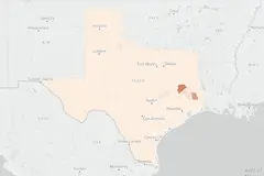
Jon Shapley/Staff photographerStorm survey teams from the National Weather Service on Friday had confirmed two EF1 tornadoes with peak wind speeds of 100 to 110 mph: One was near Cypress in Harris County and the other in Waller County, according to preliminary findings.
The weather service had three survey teams out in the Houston metro area on Friday to verify reports of tornadoes, after storms tore through Southeast Texas on Thursday, uprooting trees and damaging buildings.
Advertisement
Article continues below this ad
The first twister struck in Waller County, starting at 5:44 p.m. Thursday about 5 miles south-southeast of Pine Island. With estimated peak wind speeds of 100 miles mph, the tornado lasted only about a minute, cutting a path only 0.71 mile long and 100 yards wide, the weather service said. It destroyed a large metal barn, rolled trailers and left metal debris strewn across 1,000 yards to the southeast. Trees fell in different directions, from south to northwest.
The second tornado began at 6:08 p.m. Thursday near Cypress, about 8 miles west-northwest of Jersey Village, in Harris County. Like the Waller County tornado, this twister lasted only a minute, packing peak winds of 110 mph and cutting a path only a 0.77 mile long and 100 yards wide.
It touched down near the intersection of Tuckerton and Greenhouse roads, before tracking southeastward through the Highlands subdivision, the weather service said.
No deaths or injuries were reported in either tornado.
Advertisement
Article continues below this ad
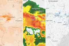
One weather service storm survey team in downtown Houston had determined that the area was hit by significant straight-line winds that blew out windows on the exposed north and west sides of buildings. Winds in this area peaked at around 100 mph, according to the team’s early findings.
Meanwhile, the survey team in the Baytown area found widespread wind damage from straight line-winds of 90 to 100 mph. Large hardwood trees had been snapped and the team observed roof and vehicle damage across the area.
Later on Friday, the weather service determined that Thursday night’s storms constituted a derecho event, based on the length of the path of destruction and intensity of the winds.
Some Houston residents might already know derecho means “straight ahead” in Spanish, and its meaning in meteorology is not that far off. A derecho, which is a widespread, straight-line wind storm, can produce damaging winds over areas hundreds of miles long and more than 100 miles across, according to the weather service.
What qualifies as a tornado?
Starting with the basics, a tornado is a violently rotating column of air that extends from the base of thunderstorm clouds and touches the ground. Although they are recognizable by a funnel-shaped cloud, a cloud of debris also can mark the location of a tornado even if a funnel cloud is not visible, the weather service says.
Advertisement
Article continues below this ad
Tornado winds can reach 300 mph and damage paths can be wider than a mile or even 50 miles long. The weather service said some tornadoes develop extremely fast while others may dissipate just as quickly. Most tornadoes are on the ground for less than 15 minutes.
Once the weather service — using onsite damage inspections, observations from Doppler radar and other data — confirms a tornado has occurred, the agency then calculates how strong of a tornado it was by surveying the damage and comparing it to damage to similar objects at certain wind speeds.
The weather service then uses the Enhanced Fujita Scale to compare the tornado to previous events. On the lowest end, an EF0 tornado can have gusts 65 to 85 mph, while the highest-rated, EF5, can produce gusts stronger than 200 mph.
What about Thursday night’s storms?
CenterPoint Energy on Friday said that the series of storms Thursday night damaged transmission and distribution electric systems. They cited wind gusts of 65 to 85 mph and sustained winds equivalent to a tropical storm.
Advertisement
Article continues below this ad
“The hardest-hit area was likely over the U.S. 290 corridor from Jersey Village to Waller (e.g., North region west of I-45) where there was strong evidence of a tornado based on Doppler radar data,” CenterPoint said in a statement.
It’s true that Thursday’s storms had traits suggesting that it had spawned tornadoes. For instance, Doppler weather radar can detect the circulation linked to thunderstorms that can produce a tornado. That’s typically when the weather service issues its tornado warnings.
Because radar can only indicate rotation aloft in the atmosphere, forecasters rely on storm spotters on the ground to confirm whether the radar signature is associated with a tornado. But many of the key ingredients for tornado formation also were present Thursday night:
Advertisement
Article continues below this ad
- Atmospheric instability, in which you have warm, moist air near the ground interacting with cooler, dry air aloft.
- Wind shear, or change in wind speed and/or direction as you go higher into the atmosphere.
According to the weather service, “an unstable air mass promotes the development of strong updrafts, while wind shear will further increase the strength of the updraft, and promotes the rotation from which tornadoes are produced.”