Iowa tornadoes kill 1, cause major damage in Greenfield, south of Des Moines, amid severe storms


ADAMS COUNTY, Iowa -- Multiple tornadoes tracked across western Iowa on Tuesday afternoon, leading to at least one death and causing major damage to a small city as robust storms roar to life in the Midwest.
The storm-related death occurred in Adams County, Iowa - about 90 miles southwest of Des Moines - the county medical examiner Lisa Brown told CNN.
Our coverage of this story has moved here.
Brown was unable to give additional details on the death, but said it was due to a tornado.
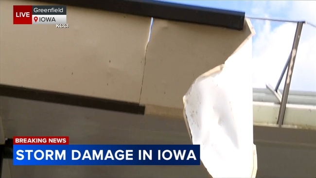
A destructive storm also went through the city of Greenfield, Iowa - about 50 miles southwest of Des Moines - and produced a tornado shortly before 5 p.m., causing "a lot of damage" to many houses and other structures, Iowa State Patrol spokesperson Sgt. Alex Dinkla told CNN.

Video taken by CNN affiliate KCCI shows the destructive path of the tornado that ripped through Greenfield. Decimated homes and flattened structures, piles of debris, damaged cars and countless toppled trees can be seen in the footage.
"There is basically nothing left," Clel Baudler, a former Iowa state representative who lives a half mile from Greenfield, told CNN on Tuesday. "It went right through Greenfield."
The potent line of thunderstorms developing Tuesday afternoon prompted a rare "potentially dangerous situation" tornado watch for parts of Iowa, Minnesota, Wisconsin and Illinois from the Storm Prediction Center. The special kind of tornado watch is only issued when there's unusually high confidence in the potential of multiple long-lived and EF2 or stronger tornadoes.
Iowa Gov. Kim Reynolds authorized a proclamation of disaster emergency for 15 counties due to the storm outbreak, saying it will allow state resources "to respond to and recover from the effects of the severe weather," in a news release.
Over 65,000 customers were out of power in Iowa as of 8 p.m Tuesday, according to Poweroutage.us.
Tornadoes are one of the many serious hazards expected with Tuesday's severe thunderstorm outbreak, according to the SPC. Destructive, hurricane-strength wind gusts up to 90 mph and softball-size hail are also likely.
More than 25 million people across the region are under a Level 3 of 5 or Level 4 of 5 risk of severe thunderstorms Tuesday, the SPC said.
The biggest area of concern for widespread, hazardous impacts centers on much of Iowa, northwest Illinois, southwest Wisconsin and northern Missouri. Chicago, Milwaukee and other population centers are also at risk of damaging storms.
The Des Moines International Airport temporarily closed late Tuesday afternoon as dangerous storms headed into Des Moines, prompting tornado warnings. The city remains in the bull's-eye of the strongest storms and potential tornadoes.
"Two tornado warnings for the Des Moines metro with both warnings having observed tornadoes. Seek shelter," the National Weather Service office there said at 4:45 p.m. local time.
Emergency management officials in Montgomery County, Iowa, confirmed "multiple tornadoes" occurred within the county Tuesday afternoon, and no injuries have been reported thus far. Officials are currently working on clearing roads to access affected properties.
"Damage assessments will be ongoing this evening and tomorrow," the agency said.
Flash flooding triggered by heavy rainfall also poses a threat for parts of Iowa, Minnesota, Wisconsin and Nebraska, where flood and tornado watches are in effect Tuesday afternoon. Rainfall totals of 1 to 3 inches are possible with some places eyeing totals of up to 5 inches.
Storms are expected to reach their peak strength in the Midwest through the afternoon and carry into Tuesday night.
Powerful storms pushed through parts of the Midwest Tuesday morning and unloaded damaging hurricane-force winds and flooding rainfall. Parts of Omaha were plunged underwater Tuesday morning as 3 to 6 inches of rain deluged eastern Nebraska. Multiple water rescues unfolded in the city, the Omaha Fire Department said on X.
Additional severe thunderstorms are expected to develop on Wednesday in a 1,500 mile stretch from Texas to western New York. Any storm could unload damaging winds and hail. A few tornadoes are also possible on Wednesday, mainly from Texas to Kentucky.
Rounds of severe storms have been making their way across the US over the past week, including a devastating storm that struck Houston on Thursday, leaving hundreds of thousands of residents without power amid unseasonable heat.
Dangerous heat in Houston amid power outages
High temperatures in Houston will push into the 90s each afternoon for much of the week as a large number of residents remain without power due to destructive storms on Thursday.
Severe storms unleashed a tornado and 100 mph winds last week on Harris County, which includes Houston, and sent sheets of rain and large debris whipping through the air as people took cover inside cars, grocery stores and hotel lobbies.
The violent conditions killed at least eight people, ripped out skyscraper windows, downed critical power infrastructure, caused a sewage spill and made roads impassable.
Electricity has yet to be restored for more than 140,000 homes and businesses in Harris County as of Tuesday morning, according to PowerOutage.us. While authorities had previously warned that power restoration could take weeks, the area's power utility has promised an earlier timeline.
Power restoration will be "substantially complete" in Harris County by Wednesday evening, power provider CenterPoint Energy said in a Monday news release.
But heat will take a very concerning turn for anyone that remains without power after midweek.
A dangerous heat wave is ramping up over south Texas this week and will reach the central Gulf Coast by the weekend. Some daily high temperature records could be broken. The worst heat is expected to begin over the weekend in the Houston area. Memorial Day could be the hottest day of the year so far in the city, according to the National Weather Service.
"Record or near-record warm overnight temperatures will provide little to no relief to those without adequate or reliable cooling," the National Weather Service warns.
Heat is the deadliest form of extreme weather and poses a growing threat as human-driven climate change leads to longer and more intense periods of excessive heat.
The heat index - a measurement of how hot the body actually feels - will climb into the upper 90s in the afternoons and occasionally reach 100 degrees for much of the work week. Heat index values from 105 to 110 degrees are possible over the weekend.
Heat relief will finally arrive toward the end of the month.
Correction: An earlier version of this story misspelled the name of power provider CenterPoint Energy.
Copyright 2024 Cable News Network. Turner Broadcasting System, Inc. All Rights Reserved.


