.svg)
File:Map of Montalto Uffugo (Province of Cosenza, region Calabria, Italy 2024).svg
Jump to navigation
Jump to search

Size of this PNG preview of this SVG file: 600 × 600 pixels. Other resolutions: 240 × 240 pixels | 480 × 480 pixels | 768 × 768 pixels | 1,024 × 1,024 pixels | 2,048 × 2,048 pixels | 1,333 × 1,333 pixels.
Original file (SVG file, nominally 1,333 × 1,333 pixels, file size: 2.72 MB)
Captions
Captions
Add a one-line explanation of what this file represents
Summary[edit]
.svg&action=edit§ion=1)
| Description |
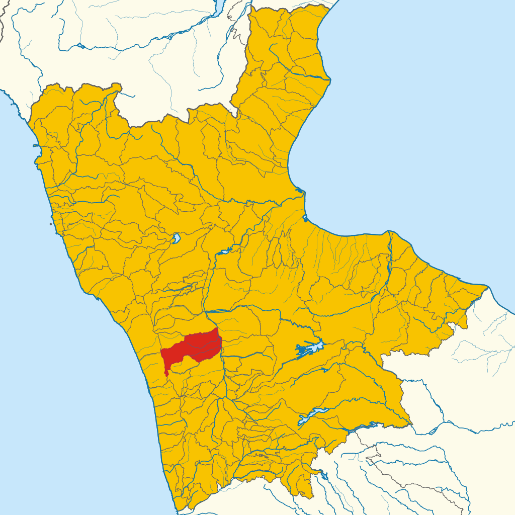
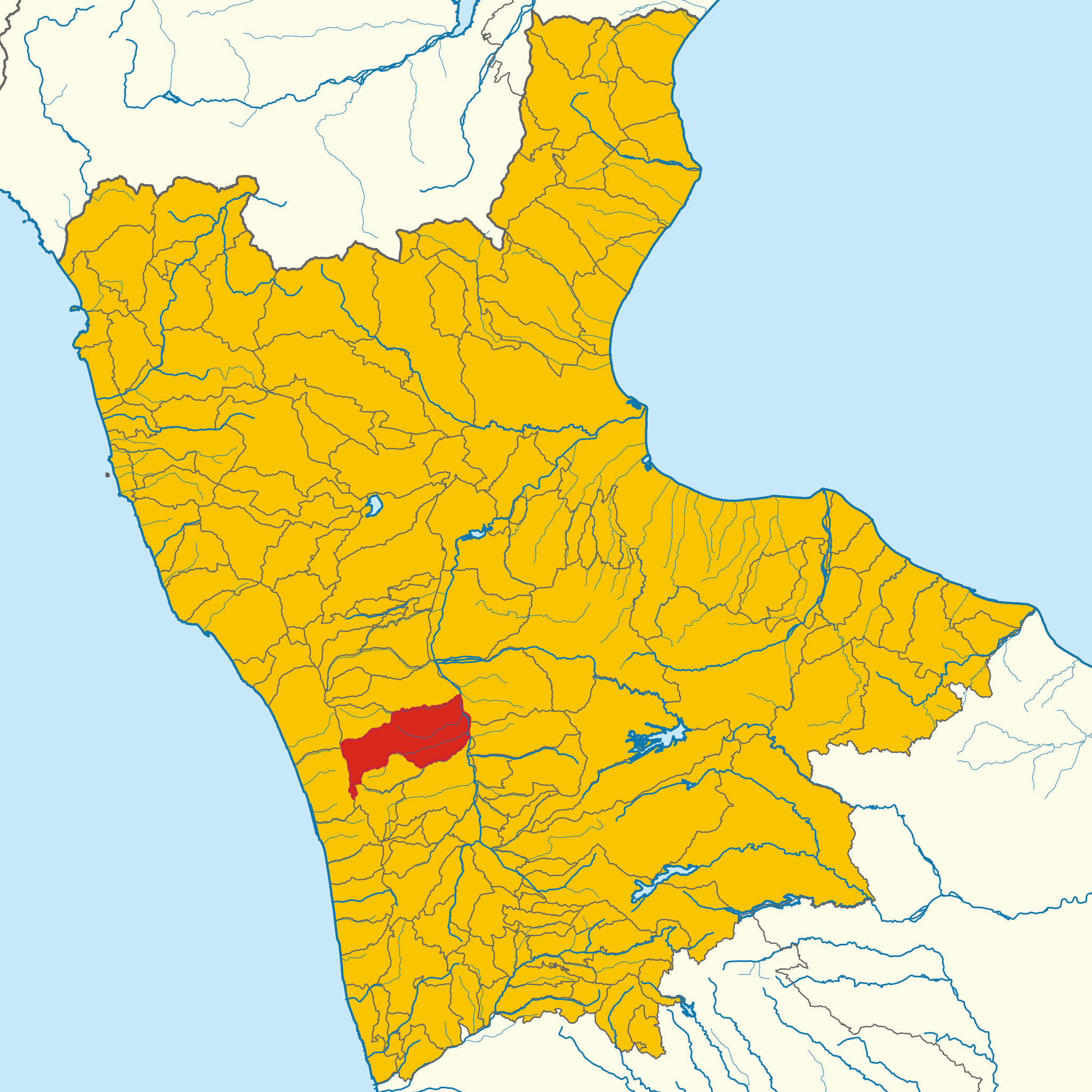
English: Map of Montalto Uffugo in 2024 (Province of Cosenza, region Calabria, Italia)
Italiano: Mappa di Montalto Uffugo nel 2024 (provincia di Cosenza, regione Calabria, Italia) |
| Map legend |
Italiano: Terreno:
Comune
Altri comuni della stessa provincia
Italia
Resto del mondo
Confini: Confini comunali/provinciali
Confini regionali
Confini nazionali
Altri elementi: Fiume
Torrente
Lago / Mare English: Terrain:
Municipality
Other municipalities in the same province
Italy
Rest of the World
Confini: Municipal/provincial boundaries
Regional boundaries
National boundaries
Altri elementi: River
Stream
Lake / Sea |
| Date | |
| Source |
English: Administrative division: Confini amministrativi 2024 , ISTAT.
World coastline: Coastal lines 2016, Eurostat. Countries boundaries: Countries 2020, Eurostat Rivers: Reticolo Idrografico Nazionale, ISPRA data.europa.eu. Lakes: Laghi e altri specchi d'acqua, Italian Ministry of the EnvironmentItaliano: Confini comunali: Confini amministrativi 2024 , ISTAT.
Coste: Coastal lines 2016, Eurostat. Confini Stati: Countries 2020, Eurostat Fiumi: Reticolo Idrografico Nazionale, ISPRA data.europa.eu. Laghi: Laghi e altri specchi d'acqua, Italian Ministry of the Environment |
| Creator | |
| Geotemporal data | |
| Spatial reference system | EPSG:32632 WGS 84 / UTM zone 32N |
| Georeferencing | If inappropriate please set warp_status = skip to hide. |
== Licensing ==
I, the copyright holder of this work, hereby publish it under the following license:
This file is licensed under the Creative Commons Attribution-Share Alike 4.0 International license.
- You are free:
- to share – to copy, distribute and transmit the work
- to remix – to adapt the work
- Under the following conditions:
- attribution – You must give appropriate credit, provide a link to the license, and indicate if changes were made. You may do so in any reasonable manner, but not in any way that suggests the licensor endorses you or your use.
- share alike – If you remix, transform, or build upon the material, you must distribute your contributions under the same or compatible license as the original.
File history
Click on a date/time to view the file as it appeared at that time.
| Date/Time | Thumbnail | Dimensions | User | Comment | |
|---|---|---|---|---|---|
| current | 22:06, 10 May 2024 | | 1,333 × 1,333 (2.72 MB) | MappeComuniBot (talk | contribs) | Uploaded municipal boundaries for Cosenza province in 2024 (details) |
You cannot overwrite this file.
File usage on Commons
There are no pages that use this file.
File usage on other wikis
The following other wikis use this file:
- Usage on diq.wikipedia.org
- Usage on es.wikipedia.org
- Usage on eu.wikipedia.org
- Usage on fr.wikipedia.org
- Usage on hu.wikipedia.org
- Usage on ia.wikipedia.org
- Usage on la.wikipedia.org
- Usage on lmo.wikipedia.org
- Usage on oc.wikipedia.org
- Usage on sv.wikipedia.org
- Usage on tt.wikipedia.org
- Usage on vi.wikipedia.org
- Usage on www.wikidata.org
.svg&oldid=875698182)