Lords Point
Lords Point is a cape in New London, Connecticut. Lords Point is situated nearby to the locality Wamphassuc Point and the town Stonington.Notable Places in the Area
Capt. Nathaniel B. Palmer House
Museum
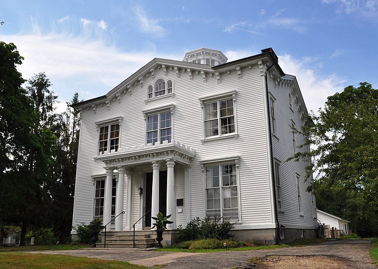
Photo: Wikimedia, CC BY-SA 3.0.
The Capt. Nathaniel B. Palmer House is a historic house museum in Stonington, Connecticut, built in 1852–54.
Enders Island
Islet

Photo: Utilizer, CC BY-SA 4.0.
Enders Island is an 11-acre island located within the town of Stonington, just off the coast of the Mystic section of the town, in the U.S. state of Connecticut.
Localities in the Area
Lords Point
Suburb
41°20′10″N 71°55′41″W / 41.336°N 71.928°W Catching crabs at Boulder Beach - Lords Point, 2013.Lords Point is a small private village on the Atlantic Coast in the town of Stonington, Connecticut, established in 1909.
Stonington

Photo: Pi.1415926535, CC BY-SA 3.0.
Stonington is a town located in New London County, Connecticut.
Stonington
Town
Stonington is a borough and the town center of Stonington, Connecticut, referred to by locals as "The Borough".
Lords Point
- Type: Cape
- Category: landform
- Location: New London, Connecticut, New England, United States, North America
- View on OpenStreetMap
Latitude
41.33301° or 41° 19' 59" northLongitude
-71.92903° or 71° 55' 45" westElevation
7 feet (2 metres)Open Location Code
87HC83MC+69OpenStreetMap ID
node 7518449692OpenStreetMap Feature
natural=capeGeoNames ID
4837990Lords Point Satellite Map
© OpenStreetMap, Mapbox and Maxar
Also Known As
- Cheepachewug
- Cheepechewag
- Chipichuock
- Chippechaug Island
Other Places Named Lords Point
In the Area
Lords Point is situated close to the neighborhoods Mystic Bridge Historic District and Rossie Velvet Mill Historic District.
Localities
- Mystic
- Mystic River Historic DistrictNeighborhood
- West MysticHamlet
- WequetequockSuburb
- Noank Historic DistrictNeighborhood
- NoankVillage
Landmarks
- Rock IslandIslet
- Marcia Woolworth Porter PreserveNature reserve
- Platt-Lords View-Stillman MarshesNature reserve
- Knox PreserveNature reserve
- Miner CemeteryCemetery
- Stonington Breakwater
Popular Destinations in Connecticut
Escape to a Random Place
Discover the capes Pederson Point in Alaska and Cape Nao in Xàbia, Spain.
About Mapcarta. Thanks to Mapbox for providing amazing maps. Data © OpenStreetMap contributors and available under the Open Database License. Text is available under the CC BY-SA 4.0 license, excluding photos, directions and the map. Photo: Wikimedia, CC0.