Ladakh standoff: A deep dive into Galwan Valley where India, China are confronting
The most important thing which stands out about this sector is that for the first time since 1962, there has been tension in this area. And that too when the LAC is clearly defined and accepted by both the protagonists.
")
The Galwan river in eastern Ladakh has been in the news lately. It is one of the sectors where Indian and Chinese armies are in a stand-off. As per recent media reports, while both the armies are on their respective sides of the Line of-Actual Control (LAC), the situation is not yet back to normal.
The most important thing that stands out about the Galwan sector is that for the first time since 1962, there has been tension in this particular area. And that too when the LAC here is clearly defined and accepted by both India and China.
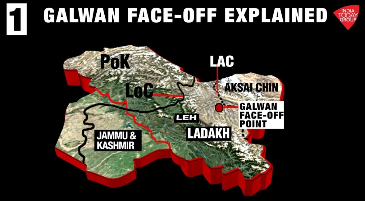
Where History & Geography Meet
Let us rewind to 1962 when China attacked India. Amongst other factors, one of the main triggers for the war was the construction of a road between Xinjiang and Tibet. This highway today is known as G219, and about 179 km of this road passes through Aksai Chin, which is Indian territory.
After having constructed the road without taking Indian consent, the Chinese went about claiming this area as theirs.
The Chinese claim line had a certain alignment till 1959 and another one by September 1962 (one month before the war). The September 1962 claim line occupied more parts of eastern Ladakh than the previous 1959 claim line. And after the 1962 war, which ended in November 1962, the Chinese occupied even more area compared to their own September 1962 claim line.
What was the driving factor behind the Chinese territorial claim and alignment of its claim line?

China wanted to keep India as far away as possible from their Xinjiang-Tibet highway. Towards this end, the Chinese drew their claim line in a manner to occupy all the major mountain passes and crestlines.
Mountain passes are required to move across mountain ranges and by controlling them, Chinese wanted to prevent any major west to east movement by the Indian Army. Similarly, by ensuring that LAC passes through the highest crestline, India does not control dominating heights.
In case of crestlines, the Chinese ensured that the LAC passes not only through the highest crestline but the one which was located as west as possible. That way, there will be more depth between LAC and the Chinese G219 highway.
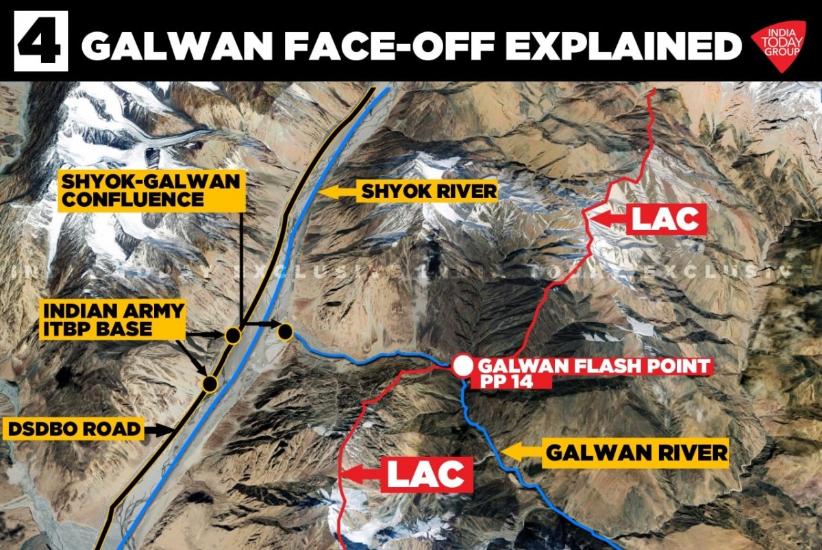
In case of Galwan river, the highest ridgeline which allows the Chinese to dominate the Shyok route passes relatively close to the river. Further, if the Chinese did not control the whole of the Galwan river valley, India could use the river valley to emerge on the Aksai Chin plateau and threaten Chinese positions there.
As can be seen in the map above, the LAC alignment turns sharply towards west, following the highest crestline in the area. Hence, in this area, the LAC runs close to the Shyok river. And since the recently constructed Darbuk-Shyok Village - Daulat Beg Oldi road (DS-DBO road) runs along the alignment of Shyok river, this vital line of communication is also close to LAC.

Galwan River & 1962 War
Galwan river was one of those areas in eastern Ladakh, where in the name of showing Indian flag to the Chinese, and proclaiming ownership of the area, army posts were set-up. Beyond the grit and determination of the men who manned these posts, these posts lacked strength in terms of manpower or firepower to provide any meaningful resistance to the superior Chinese forces.
Posts created in the Galwan river valley were no different.
In mid-1962, troops from 1/8 Gorkha Rifles (1/8 GR) went north from the Hot-Springs in the Chang-Chenmo river valley and established a post opposite Chinese post in the area at Samzungling. What is interesting here is that the 1/8 GR post was towards the head or source of the river. In the map above, this point would be in close to where the Galwan river arrow is pointing. This is about 70+ kilometres east of the confluence of Galwan with Shyok river.
From its very inception, the Indian Army posts were surrounded by the Chinese on all sides. Consequently, the posts had be maintained through Mi-4 helicopters.
A few days before the Chinese attack on 20th October 1962, troops from Alpha Company of 5 JAT, under the command of Major H.S. Hasabnis, replaced the 1/8 GR troops.
Indian posts in the Galwan sector were struck early in the morning of 20th October and despite facing overwhelming odds, continued to offer resistance for next 24 hours. But they were hopelessly outnumbered and lacking in firepower.
And yet, 36 of the 68 men across various posts in Galwan valley laid down their lives while few managed to break-out of the Chinese stronghold and fall back on Indian positions along Shyok-Galwan confluence. Major H.S. Hasabnis was wounded and taken prisoner of war.
After 1962 war, nothing more happened in this sector and so far, it had been lying dormant.
River of Death
In olden times, when caravans used to ply between Leh and Yarkand and Kashgar in present Xinjiang in China, they used to travel along Shyok river during winters when the Shyok river was frozen. Caravans went from Leh, crossed Ladakh range at Chang La pass, reached Darbuk, then Shyok village and from there, along the alignment of Shyok river reached Murgo and thence, to Depsang Plains, DBO and Karakorum Pass.
The reason this was called as winter route is that during summers when the glaciers feeding the Shyok river melted, the water level in the river used to be high and water current very fast. The caravan route alignment was such that Shyok river had to be criss-crossed from one bank to another multiple times. Many men and animals were lost trying to undertake this journey in summers.
Hence, the river was named Shyok - River of Death.
Road to Sub-Sector North
The north-east corner of the Union Territory of Ladakh which is under Indian control is referred to as Sub-Sector North (SSN) or more simply as DBO (Daulat Beg Oldi) Sector. DBO sector represents Indian presence on the Aksai Chin plateau which otherwise is mostly controlled by the Chinese.
Lacking any proper road to reach this area, it was primarily maintained by air with a mix of fixed wing aircraft and helicopters.
More than a decade back, Border Roads Organization (BRO) started to work on a road which would connect DBO with Darbuk and thence, through existing roads, with Leh. The road planned by BRO ran along the alignment of Shyok River in the area. However, this exercise was not completely successful because the road ran mainly along the western bank of Shyok river and during summers, when the glaciers melted and the water level in Shyok river arose, the road would get washed away or submerged and cease to exist at multiple places.
Some years earlier, BRO changed tactics and at vulnerable locations, it built road into the mountain walls on the western bank of the river; this was done by blasting the mountain walls and then building a road along it.
With this road having become operational, Indian Army has got the ability to much more quickly move troops and material into the DBO sector. Where earlier, it relied mainly on air-maintenance, now the same can be done through surface transport.
Chinese Infrastructure in Galwan River Valley
A perusal of historical satellite imagery shows that by 2016, Chinese had built a compacted road till the middle point of the Galwan valley. It can be safely assumed that by present times, the Chinese have extended this road till some point close to LAC in the sector.
Further, it has built small posts in the river valley which most likely act as forward patrolling bases for the Chinese troops. The nearest large Chinese base is in Heweitan, which is ~48 km north-east as the crow flies from the LAC in the area.
In the current scenario, it can be safely concluded that Chinese troops came from rear bases in relatively small numbers to create a stand-off in this sector.
Current Stand-Off
As per available information, Indian and Chinese troops had a face-off in the Galwan river sector in the first week of May. Chinese troops, traveling along the Galwan river from their rear base(s), are supposed to have crossed the LAC in this sector. And they were confronted at a point known as Patrol Point 14 (PP14), which on Indian side but very close to the LAC. Post the engagement, the Chinese troops are supposed to have gone back to their side of the LAC.
Satellite images shared by some analysts on social media show that there is some troop built-up on either side of the LAC by both the countries. However, there is no evidence so far of the Chinese having squatted on Indian side of LAC or captured any territory.
As explained earlier, the LAC runs very close to the alignment of the Shyok River in this sector and by extension, to the new DS-DBO road. The confluence of Shyok and Galwan river is ~8km from the LAC and hence, the added sensitivity.
The supposed trigger for the Chinese aggression in this area is an attempt by the Indian Army to build a feeder road emanating from DS-DBO road and which comes till PP-14. Such a road will improve India's ability to patrol this area and to respond to any exigency.
The Indian government has already communicated that infrastructure work in the entire Ladakh sector, including Galwan River area, will continue and be completed as per the original requirement.
Conclusion
Galwan Sector remains a sensitive area because of the proximity of DS-DBO road to LAC and threat of interdiction by the Chinese. However, this would have been known to Indian planners from the beginning itself. Further, this is not the only segment of DS-DBO road which faces this threat from the Chinese, there are other segments as well. In addition to this, during any conflict, the road will also come under long-distance artillery fire as well.
But this does not reduce the significance of the road. It will continue to serve the army in peacetime and help in building up troops and materials before any shooting match starts. Further, you can expect the army to take adequate measures to protect the road. At the same time, the army is also working on developing an alternate route to DBO sector which lies in depth within Ladakh and does not suffer from same threat as DS-DBO road.
As for the current stand-off, since there is no differing perception of opinion in this sector, nor is there any evidence of the Chinese having come into India side of LAC, it should be easiest to settle. However, at this stage, there is no clarity as to when this is likely to happen.